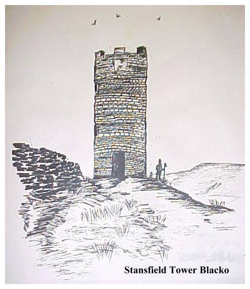

Welcome to the oddities of Lancashire! There are fewer follies here than in neighbouring Yorkshire, but what they lack in number they more than make up for in quality. Indeed it is Lancashire that is able to lay claim to few superlatives - the tallest (Blackpool Tower), the biggest (Ashton Memorial),
the most innacessible- (Ellesmere Memorial) and the most vandalised -(Billinge Beacon).
We will embark upon a series of walks in which we will visit follies, prospect towers and curiosities in this most interesting of counties. We will walk over hill and dale, through woodlands and over sombre moors. We will also sample some of the more urban aspects of Lancashire's landscape, but above all, by the time you have completed all the 'days out' in this book you will have gained an insight into and an understanding of the fascinating topography of north western England..
To many people, Lancashire means red brick cotton mills and Lowry-esque industrial skylines. But this label is no more typical of Lancashire than the 'muck and brass and cloth caps' image is to neighbouring Yorkshire. In fact Lancashire has a highly diverse landscape, well endowed with coyly hidden charms, which, unlike the more obvious natural wonders of Yorkshire need to be sought out in order to be fully appreciated.
Lancashire is not what it was. Like Yorkshire it was 'mucked about' by the local government reorganisation, which resulted in great chunks of its traditional anatomy being carved up and distributed elsewhere.
I have of course, cunningly ignored all these subtle changes. What today passes for 'Lancashire' has no more ethnic reality than 'Humberside'. I would not seek to insult an 'Owdham Mon' by referring to him as a 'Greater Mancunian'! My Lancashire therefore is the Lancashire of old, Merseyside, Manchester and 'Oversands'included.
Before Columbus people believed the world was flat. Before I went to college in Liverpool I believed the same of Lancashire. Not so. In reality Lancashire has more hills than flatlands. Passing over Blackstone Edge, the traditional gateway from the old West Riding into Lancashire, the vast basin of Greater Manchester falls away to the southwest. Into this basin empty numerous upland rivers, eventually joining forces to enter the Irish Sea via the River Mersey. This vast, predominently urban area, stretching away to Warrington and the Cheshire lowlands, constitutes the greater part of 'Flat' Lancashire.
Southeastern Lancashire flirts with the Peak District National Park before giving way further northwards to the 'edges' of the South Pennines. North of Rochdale however, the Pennines fan out westwards, running to the north of Greater Manchester, forming a high upland barrier twixt Mersey and Ribble, which reaches its climax on the moors around Belmont. This area is characterised by moors, industrialised valleys (like Rossendale), and roads which run largely north to south.
Northwards again and we encounter the hills around Nelson, Colne and the Aire Gap, a westward running ridge which reaches its climax in the great whaleback of Pendle before falling away to the Ribble around Whalley. This is 'Witch Country'.
North of the Ribble the landscape changes. West of Clitheroe is Longridge and to the north of it the vast wildernesses of the Bowland Fells. Here the landscape is totally rural with sleepy villages where time seems to stand still. There are no industrialised valleys and little public right of access to the countryside.
As Belmont looks towards Preston, so the Bowlands look down on Lancaster, Lancashire's 'Capital', dominating the mouth of the River Lune. The Lune rises in what was formerly Westmorland, in the Howgill Fells. North of the Lune, Morecambe Bay cuts deeply into the landscape, and much of what should be Lancashire is sands. Yorkshire and Westmorland loom large hereabouts, and Lancashire merely gets a strip of that complex geological cocktail of hills which lie twixt Morecambe Bay and the western fells of the Yorkshire Dales.
Lancashire's coastal strip is a rage of sand. The sandscape is at its grandest between the Mersey and Ribble estuaries. Formby, Ainsdale and Southport are characterised by vast, endless beaches backed by high dunes. On a busy day people appear as tiny, Lowryesque dots, and hazy vistas stretch from the Welsh Mountains to the Lakeland Fells. North of the Ribble, the Fylde, with Blackpool and its tower, is much the same. Beyond Fleetwood a quieter landscape stretches up to peaceful Glasson Dock and Sunderland Point, before the coast turns into the vast expanse of Morecambe Bay.
Oversands there is no real coastal strip. The rocky outliers of the Lake District descend abruptly to the sands of Morecambe Bay. On the far north western shore, Black Combe juts out into the sea behind Barrow-in-Furness, effectively blotting out any view along the Cumbrian coast. By this point, however, we have already passed beyond Lancashire's 'outer limits'.
This then, essentially, is the distinctive topography of Lancashire. On our journeys in search of Lancashire's follies and curiosities, we will sample all of these landscapes to a greater or lesser degree. From Lakeland to the Mersey, from the South Pennines to Southport, Lancashire awaits.
So what are we waiting for? Pack your boots in the boot and lets get going. It's time to see if we can find some 'Towers and Terraces'.
Jim Jarratt Mytholmroyd 1991