
Accrington Eyecatcher,- New High Riley
Georgian eyecatcher tower with quatrefoil windows. Not located.
Bury Kay Memorial- Map Ref: SD802 108
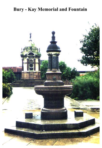
Bury's finest jewel is its Kay Monument at the south end of Market Street. A pavilion with a stone dome surmounted by a bronze fame, this was erected to the memory of John Kay,, inventor of the 'Flying Shuttle' which was so instrumental in the Industrial Revolution. Kay was born in Bury in 1704. A bronze portrait of Kay in relief surmounts a panel containing an inscription. On either side of the monument are depictions of a power loom and a hand loom. Adjacent to the monument is a fine drinking fountain, presented to the town by John Barlow JP of Wellfield in 1907.
Bury also has a fine Clock Tower built in memory of Walter Whitehead, a Manchester surgeon. It is stone-built and square, and was designed by Maxwell and Tuke in 1914. It has four keep-like turrets.
Colne - The Wallace Hartley Memorial
This bust on a plinth was erected to the memory of the bandmaster of the Titanic who went down with that ill-fated ship on April 15th 1912. Apparently Hartley led his band in a rendition of the hymn 'nearer my God to Thee' as the liner slid beneath the waves!
Delph/Denshaw Monument - Map ref: SD 968 082 Sheet 109.
Obelisk on hillside near Grains Bar. (Picnic/parking.)
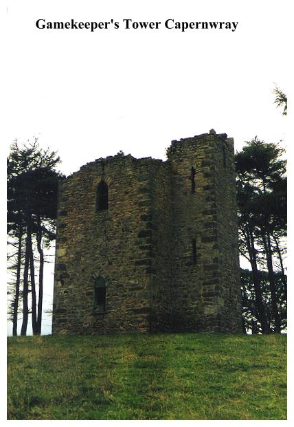
Capernwray - The Gamekeeper's Tower.Map Ref.:SD 542 714
The nineteenth century gothic tower near Capernwray Hall is in a ruinous condition and needs to be saved before it is too late. Access to it involves locating a decayed and rarely-used footpath, which leads up the hillside from the nearby Hobsons Caravan Park. The walk is a pleasant stroll with nearby woodlands and a possible chance of sighting red deer. It is not, however, a substantial enough walk to merit a full chapter in this book. You could perhaps take it in en route to the Pepperpot which lies not too far distant at Silverdale.
Little is known about the Capernwray Tower. It belonged of course, to the estate of nearby Capernwray Hall, being built by Mr George Marton (the builder of the present Capernwray Hall) as a lookout tower and a residence for his head gamekeeper. The tower is a listed building, and prior to its present ruinous condition was used by the the Boy Scouts. In 1979 it was reported at a parish council meeting that the tower had been vandalised, and its state has progressively worsened since. According to the local farmer the tower is still frequented by vandals, which seems surprising, considering the remote location of the place.
Successive Martons lived at Capernwray Hall until death duties forced them to sell the house in 1946 for the princely sum of £7,350. Today the hall is a young people's Christian holiday conference centre.
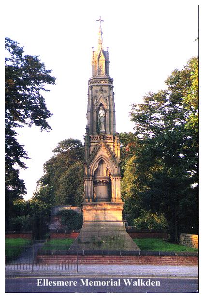
Ellesmere Memorial, Walkden.- Map ref: SD 739 031 SHEET 109.
By the church in the centre of Walkden on the site of the original Bridgewater Offices and Sunday school. Built in the style of an Eleanor Cross the memorial is a tabernacle with a very high pinnacle, fifty feet high. It was erected in memory of Harriet, the wife of Francis Egerton, 1st Earl of Ellesmere, a much-loved lady who was a founder of local schools and a friend to the poor. On the corners figures (now missing) depicted a collier, a cotton worker and two factory girls. The larger statues, which still remain, are of chastity, prudence, piety and munificence. The monument was dedicated on the 26th July 1869. Presiding over the ceremony was Mr Fereday Smith, who was also much involved with the construction of the other Ellesmere Memorial at nearby Worsley. The Memorial was originally surrounded with steps and railings but these have since disappeared.
Fleetwood - The Lighthouses. Map ref: SD 338 487.
Although not strictly speaking follies, Fleetwood's two land based lighthouses are most certainly unusual, being quite different from what you would normally expect and therefore worthy of mention. Both are the work of Decimus Burton, the top London architect who was responsible for designing much of Fleetwood, which from the outset was very much a 'planned' town. The lighthouses were originally gas-lit before being converted to electricity, and were intended to help boats navigate the Wyre Channel. The Lower Lighthouse is situated on the seafront, a classical structure incorporating a balustrade, columns and a shelter with seats. It is constructed of Stourton Hill white stone. The Upper Lighthouse just beyond it is known as the Pharos Lighthouse, because it was designed to be a replica of the Pharos of Alexandria, that famous lighthouse that was held to be one of the Seven Wonders of the Ancient World. Fleetwood's version is, I suspect, somewhat less impressive, being a red sandstone column standing some ninety feet above the high water level.
Gisburn.
Sham castle dog kennels. Also Temple by River Ribble on private land. Has not been visited.
Heaton Park - Manchester.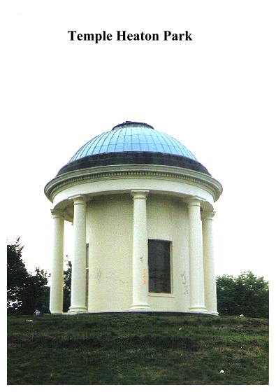
Map ref SD 839 045 Sheet 109
Heaton Park, with its Hall, lake, golf courses, woodlands and vast open spaces is Manchester's playground. It originally was the home of Sir Thomas Egerton, the first earl of Wilton. It also contains a number of interesting follies.
Smithy Lodge, by the eastern entrance is an octagonal building with eight tuscan columns.It was designed by Lewis Wyatt and built in 1806.
To the North East of the Hall there is a Temple on the hill, boarded up and vandalised, a small rotunda of Tuscan columns with a dome and lantern. The Temple was reputedly built as an observatory, for it is reported that the first earl bought a telescope from Dollonds in 1803 for £18 5s 0d.
The Papal Monument, a shapeless block of granite in the southwestern corner of the park, looking for all the world like some bizarre glacial erratic, commemorates the visit of Pope John Paul II to Manchester in 1982. It is erected on the spot from which he conducted a mass attended by over 30,000 people.
The Telecommunications Tower on the northern side of the park stands at the highest point in Manchester. It is 230 feet high and bristles with dishes and aerials. It is run by British Telecom and forms part of the national radio relay system for the trunk telephone and television network.
The Manchester Town Hall Portico, Manchester's 'Great Gate of Kiev', stands by the lake. It is Heaton Park's finest (and most obvious) folly. The town hall it came from originally stood in King Street, Manchester. It was designed by Francis Goodwin and was constructed in 1819-34. The portico was rebuilt here in 1912, about the same time as the construction of the lake, to which it makes an excellent foil. Four enormous Ionic columns support the architrave between its two endbays, which contain niches with statues.
Holymosside Tower.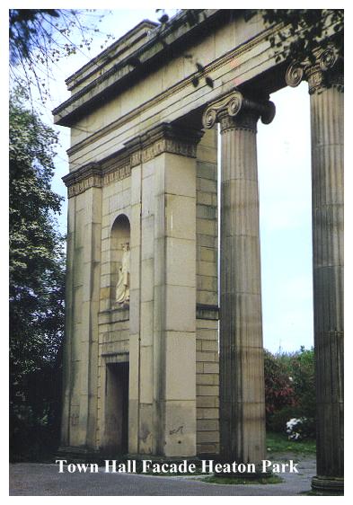
Near Belmont. Eighteenth century, sixty two feet high and reputedly haunted. Perhaps the tower itself is a ghost because I can't find it!
Holme Island, near Grange-Over-Sands. Map Ref SD 423 782.
This rocky 'island' sticking out into the sands, which is in fact connected to the 'mainland' by a raised roadway, contains gardens, fountains, urns and a circular Temple of Vesta, supported by sixteen Corinthian pillars and adorned with five panel paintings. All of this could be once explored by tourists from Grange on payment of a one shilling. Today the whole estate is STRICTLY PRIVATE.
Ince Blundell Hall. Map ref: SD326 029 South East of Formby.
Ince Blundell is delight. Its parkland, (petite by eighteenth century standards!) is surrounded by a rusty red brick wall, which screens it from the hum and clamour of the adjacent busy main road. Inside the wall is another world - a place of woods, gardens and quiet peaceful seclusion. Ince Blundell Hall is now a convalescent home. It is not public (which accounts for its peace and quiet) but neither is it private, and with the exception of a small garden containing a pavilion, you can stroll around the grounds and lakeside undisturbed.
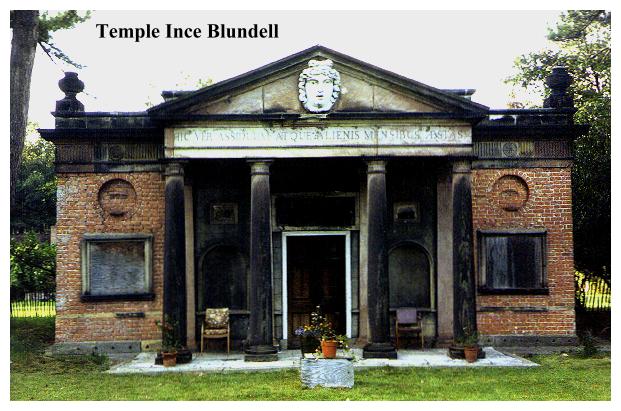
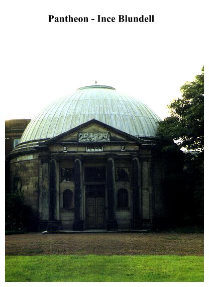
Ince Blundell Hall was built in 1777, when Henry Blundell decided to replace his old Tudor hall with an up-to-date mansion. Blundell was a dedicated art collector, much travelled on the Continent, and rather than fill his house with his treasures he decided to design two buildings especially for the purpose. The larger of these, The Pantheon, is attached to the far side of the hall, and was built to house Blundell's collection of antiquities, paintings and drawings. It is circular and fronted with a severely Classical portico. To house his collection of sculptures, Blundell built a fine Garden Temple, also looking to all intents and purposes like a refugee from ancient Rome. It is constructed of red brick with a portico of four Tuscan columns, and antique reliefs. It was designed by William Everard of Liverpool and constructed about 1780. Originally a greenhouse stood behind it, and it is to this that the inscription refers.
Ince Blundell has other structures of interest to the folly hunter. In front of the house is a Monument:- a white Tuscan column with one eagle - and at the southern end of the park there is a magnificent Lion Gate standing alongside the main road. Also alongside the main road is the Priest's House opposite the Victorian estate entrance. This is a circular building, with a circular chimney and flattened sides.
Attached to the hall is the Holy Family Church. A unique night-time ceremony is held here each year, in which graves in the cemetery are decorated with flowers and candles prior to a candlelit procession and church service. This custom is traditional in Belgium and was reputedly introduced to Ince Blundell at the turn of this century.
Knowsley Hall. Between Liverpool & St. Helens. Map ref:SJ 45 94
Knowsley Hall has a number of buildings of interest to the folly hunter. First there is a square tower at the side of White Man's Dam. (The White Man is actually a lead statue on a pedestal.) Also there is the Octagon, a summer house dating from 1755, intended as an eyecatcher, east of the house. The interior is stucco decorated.
Lancaster The Music Room. Map ref: SD 47 61
This lovely little building was built in 1730 for Dr Marton, Vicar of Lancaster, as a summerhouse or pavilion in what was once a private garden. The garden, however, disappeared with the construction of Sun Street, and the building became hemmed in by houses and sheds. This three storeyed building is essentially a baroque facade with a central Ionic triumphal arch at ground floor level. The interior contains fine Baroque plasterwork which has recently been restored by the Landmark Trust, who also removed some of the encroaching buildings. Depicted on the walls are the Muses of History, Music, Astronomy, Tragedy, Eloquence, Rhetoric, Comedy, Dancing and Amorous Poetry. It has been suggested that the name 'Music Room' is perhaps a corruption of 'Muses Room', the name referring to the plasterwork.
Lindeth Tower, Silverdale.
Map Ref.:SD461 742
Located near Gibraltar Farm alongside the lane leading down from Silverdale to Jenny Brown's Point. Lindeth Tower (now known as Tower House) stands securely hidden behind its high wall and 'private' notices. The upper part is visible from the roadside. This tall, grey castellated tower was erected as a belvedere in 1842 by Henry Paul Fleetwood, who owned the adjacent house. He was related to Sir Peter Hesketh Fleetwood of Rossall Hall, the man largely responsible for the town that now bears his name.
The tower is best known for its literary associations, for it was for some years after 1850 regularly occupied by the novelist and biographer of Charlotte Bronte Mrs Elizabeth Cleghorn Gaskell. Mrs Gaskell came to Silverdale during the summer months to escape the smoke and smog of Manchester where she lived. Here at this peaceful spot, with its woods, crags, salt marshes and endless sands, she walked, relaxed and worked on novels later to become famous. Of her novels,Cranford, which is supposedly based on Knutsford in Cheshire, is in fact the old-fashioned name for nearby Carnforth; and Silverdale itself was described in her novel Ruth under the name of Abermouth.
Mercer Memorial, Great Harwood. Map ref:SD 734 327 (SHEET 103)
The Mercer Memorial is a free-standing clock tower in the centre of Great Harwood, which was erected to the memory of John Mercer, Great Harwood's most famous son. Mercer, an industrial chemist, was the inventor of the Mercerisation process which gave cotton a highly attractive, silk-like sheen. Mercer was elected a Fellow of the Royal Society in 1852, and the memorial was erected in 1903 to mark his contribution to the development of Great Harwood.
Northenden. Nr. Manchester. Map Ref. Uncertain
The Shar Stone. Stands in the grounds of ruined Sharstone Hall, on a plinth like some gaunt toadstool.This curiosity, long believed to have been a meteorite, is in fact, made of volcanic ash, and was probably deposited in the Ringway area during the last Ice Age, when it travelled down from the Lake district in a glacier. The stone weighs six tons, but this did not prevent it from being transported from Ringway to Northenden by horse and cart in the 1890's! (Source Manchester Evening News 3.1.96)
Ormskirk Parish Church.Map ref:SD413 085
The Parish Church of St Peter and St Paul, Ormskirk, is unusual in that it possesses both a steeple and a tower. It is locally known as the 'Sisters Folly'. According to legend, two sisters who endowed money to the church could not agree on whether the church should have a steeple or a tower, so in the end they built both. The story is almost certainly apocryphal, for the steeple is the older of the two, dating from the fifteenth century. It has been twice rebuilt, which tends to make it look moderner than the tower. The battlemented tower was built in the sixteenth century using masonry plundered from Burscough Priory. It was built to accomodate the bells from the priory, which were brought to Ormskirk after the Dissolution.
Ormskirk itself also has a Clock Tower at the junction of Church Street. This was erected by public subscription in 1896 on the site of the old market cross.
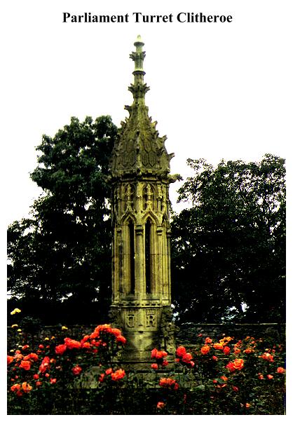
Parliament Turret - Clitheroe. Map ref. SD 742 417 (Sheet 103)
Castle Gardens, Clitheroe. Situated in the rose garden just beneath the Castle Museum, this small folly is actually a refugee turret from the Houses of Parliament in London. It originally formed part of that building and was presented to Clitheroe by Captain Sir William Brass, MP.
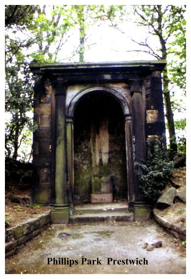
Philips Park, Prestwich. Map ref. SD797 041 (Sheet 109)
Worthy of a visit if you have exhausted the facilities of nearby Heaton Park. Not easy to find. The italianate villa of the Philips family was demolished in 1950.Philips & Co were Manchester merchants. Mark Philips was one of the first MPs for Manchester after the passing of the Reform Bill. The follies here consist of a conservatory and a temple. The conservatory is ruinous, but is currently being restored, the temple (when you find it) is a bit of a disappointment. Pleasant walks, though, with lots of dense woodland, scrub, and even a lake. An unexpectedly peaceful and sylvan landscape is hidden here, secluded, surrounded by industrial desolation and tucked neatly away beneath the busy M62.
Pots and Pans. Map ref: SE011 052.
On the moors near Uppermill, this obelisk is set in a spectacular rocky location in the midst of superb south Pennine moorlands. It is however, a war memorial, so consequently has not been included in my catalogue of walks. Well worth a visit, if only for the fine upland ramble.
Scarisbrick Hall. Scarisbrick Nr. Southport. Map ref: SD392 126
Scarisbrick Hall is not a folly, but as one of the craziest, most eccentric structures in the whole of Lancashire it most certainly deserves a mention in this book. Only Conishead Priory at Ulverston comes anywhere near it for high Victorian bad taste. The hall was designed by Augustus Welby Pugin in 1840 and completed in 1868 by Pugin's son, Edward. Pugin the Elder was responsible (an apt word!) for designing the House of Commons, and one look at Scarisbrick instantly betrays the connection. The house was commissioned by Charles Scarisbrick, High Sheriff of Lancashire, who was a bachelor, recluse and noted eccentric.When Scarisbrick died suddenly in 1860, his will required his undertakers to carry his coffin in a straight line from Scarisbrick Hall to Bescar Chapel, where a gap had been ready made in the presbytery garden wall. Consequently the funeral procession had to cross potato fields, pass through gaps cut in hedgerows and cross planks laid over ditches!
Charles' equally eccentric sister Anne inherited the house on her brothers death and set out to finish where he had left off. The original clock tower had been designed as a runner-up for 'Big Ben', but Lady Anne instead commissioned an incredibly disproportionate gothic tower over a hundred feet high, which looks poised to pull the house over onto its side. On the flat coastal plain, it makes a landmark which can be seen for miles. When Lady Anne invited Gladstone to visit just before Christmas 1867, she illuminated the whole neighbourhood with lights, and bathed her fantastically ornate home in a multicoloured glow, while her servants let off flares and fireworks from the rooftops. Today this magnificent neo-gothic masterpiece is a private boarding school for boys.
Sefton Park, Liverpool. Map ref: SJ375 875
Sefton Park contains a number of buildings and monuments of interest to folly hunters. There is a lake with a series of small pools leading to a grotto, north of which stands a replica of Alfred Gilbert's Shaftesbury Memorial (better known as Eros in Piccadilly Circus). There is also a copy of the Peter Pan Statue (1928) the original of which stands in Kensington Gardens. Seek out also two Lodges and an excellent Palm House dating from 1896. It contains a number of statues. In the park you will also find the Samuel Smith Obelisk, which carries bronze reliefs.
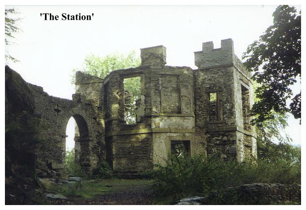
Station Ferry Near Far Sawrey by Lake Windermere. MAP REF:SD388 955
This sad castellated ruin (now in Cumbria) was once a popular Victorian resort, serving as a viewpoint over the lake. It was built early in the last century by the Rev William Braithwaite to amuse his friends. The building was once white, octagonal with a castellated roof, and two storeys high. The ground floor was a dining room with an adjacent wine cellar, while upstairs a drawing room was lit by a six-sided bay window. This contained various panes of coloured glass, through which, it is related, visitors were able to enjoy the view through the different 'seasons'. There was also a dark blue pane to simulate 'mmonlight' and a violet one to imitate a 'thunderstorm'. In the 1830s and 1840's the building was a popular venue for dances, and was even visited by Queen Adelaide in 1840. No doubt there was many a romantic encounter here in those halcyon days when the pathways were lit up with Chinese lanterns and a salon orchestra was brought in from Kendal. The Station is, alas, somewhat bleaker today.
Further up the hill heading towards Claife Heights, there is supposed to be a Summerhouse known as Belle View, also built by the Rev. William Braithwaite in 1799, but this seems to have been swallowed up by a private coniferous forest.
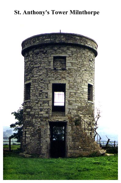
St. Anthony's Tower, Milnthorpe. MAP REF:SD499 822
Milnthorpe is not (and never has been) in Lancashire, but its location by Morecambe Bay, lying between Silverdale and Grange, makes it worthy of mention. The round, grey tower, standing on the hilltop behind Milnthorpe, and offering fine views over the Kent sands is extremely difficult of access, not being served by any public right-of-way. It is easiest approached from the single track lane on its eastern side, where you can ascend the pasture, but you do so at your own risk. The tower contains a vaulted ground floor chamber, and a first floor room reached by a winding external stair. (Now locked) From there an internal stair once wound up to the roof of the tower, where the stump of a flagpole is still visible.
The tower was built by Henry Smithies to commemorate the passing of the 1832 Reform Bill (an excuse for folly builders all over the country- see the Parbold Bottle).Wainwright states that it was built as a summerhouse for nearby St Anthony's House, which stands down on the main road. Yet this building speaks for itself, having nothing of the 'summerhouse' about it. With its steps and martial appearance, it is very much a prospect tower. (Although of course it could have served both functions) In World War II it was used as an observation post, being manned by the Home Guard. Today it stands ruinous and derelict, incredibly wasted by a town that seeks to promote tourism. How sad! Restored and open to the public, it would be a major local asset.
Sunderland Point, Sambo's Grave. Map ref: SD 422 56 (Sheet 102).
Sambos Grave is not a folly, but it most certainly is a curiosity, and as such deserves a mention in this book. Situated at the Mouth of the Lune, frequently cut off by the tide, Sunderland Point is a slumbering land that time has forgotten. Once Lancaster's chief port, it was eclipsed in the 18th century. Now Sunderland Point is left alone with its memories. A footpath, running over sandy soil between brambles, gorse and wild flowers, leads to the seaward side of the point, a realm of salt marshes and shimmering haze.
A left turn leads to Sambo's Grave, a stone slab set into a little grassy plot between a fence and a wall. Yet this is not what attracts the eye - rather it is the touching little wooden cross and the jamjar 'urn' filled with wild flowers. Sambo was an African slave who arrived here in 1736, no doubt as a household servant accompanying his master, possibly a sea captain. It is said he died of a broken heart when his master left him. Being a 'black heathen, the local churchgoers refused him a plot in their graveyard, so he was buried here at this remote and secluded spot. It seems to me that the heathen got the better deal - for while their forgotten graves crumble Sambo's is tenderly maintained.An old brass tablet touchingly tells all in the form of a uniquely lyrical epitaph:
Here lies
Poor SAMBOO
A Faithfull NEGRO
Who
(Attending his Master from the West Indies)
DIED on his arrival at SUNDERLAND
______________________________
Full sixty Years the angry Winter's Wave
Has thundering dashd this bleak & barren Shore
Since SAMBO's Head laid in this lonely GRAVE,
Lies still & ne'er will hear their turmoil more.
Full many a Sandbird chirps upon the Sod
And many a Moonlight Elfin round him trips
Full many a Summer's Sunbeam warms the Clod
And many a teeming Cloud upon him drips
But still he sleeps- till the awakening Sounds
Of the Archangel's Trump new Life impart
Then the GREAT JUDGE his APPROBATION founds
Not on Man's COLOR but his WORTH of HEART.
James Watson Scr. H. Bell del.
1796.
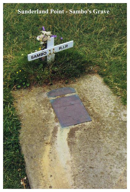
A smaller plaque, with an interesting motif above it, tells a sad story of vandalism and entreats us to 'RESPECT THIS LONELY GRAVE'.
Thinking of poor Sambo, slumbering at this remote and peaceful spot, my mind was transported to Wentworth Woodhouse in South Yorkshire, where sleeps another lost soul far from home- John Dennis Blonde - alias Chow Kwang Tseay. A strange parallel!
Tandle Hill Monument, Royton. Map ref. SD901 089 (Sheet 109)
At the north western corner of Tandle Hill country park. An obelisk.
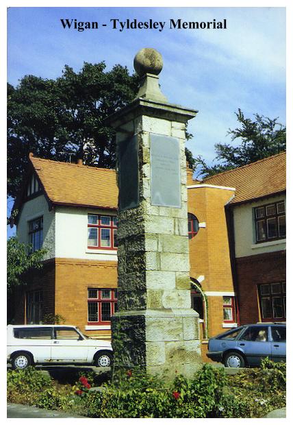
Tyldesley Memorial, Wigan. Map ref:585 065.
Located alongside the busy A49 just north of Wigan town centre heading towards the infirmary, this square stone pillar with a ball finial must surely be one of the oldest war memorials in Britain, commemorating as it does events of the Civil War. Wigan was a Royalist town which saw much trouble during the Civil Wars. In 1651, after the execution of Charles I, The Prince of Wales (the future Charles II), was supported by the Earl of Derby, who had come out of exile, and northern Royalists rallied to him, including Sir Thomas Tyldesley of Myerscough Lodge, who had fought with him on many a campaign. On the 25th August 1651 they were riding down Wigan Lane when they were ambushed by a party of Roundheads. The earl had two horses shot from under him, but managed to make good his escape. Tyldesley, however, was less fortunate and was killed along with many others on this very spot.
A slate tablet affixed to one side of the monument tells the story of Sir Thomas's career.
A second, more recent, tablet informs us that the memorial was restored by Wigan Corporation in 1886. Seeing the monument as it is now, standing in a flowerbed alongside a busy trunk road and surrounded by suburban housing, it is difficult to imagine the desperate events that must have taken place here all those centuries ago.
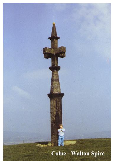
Walton Spire - Colne. Map ref SD 895 374 (Sheet 103)
This obscure folly is to be found in a field by a junction of lanes to the southeast of the ancient fort of Castercliff, which straddles the hillside between Nelson & Colne. Looking like a refugee turret from a church crossbred with a signpost, this has to be one of the oddest follies in Lancashire. Only its scale lets it down. Had it been massive, with perhaps an internal staircase and viewing platform, it would perhaps have been the wonder of the area, but alas, its smallness renders it quite unspectacular. A modern plaque (now unhappily smashed) informs us that the spire was constructed by one Richard Wroe Walton in 1835, on the site of an ancient monolith. (His reason for doing so is not made clear) In January 1984 the monument was toppled by a gale, which resulted in a petition being sent by local residents to the Mayor of Pendle pleading for its restoration, which was eventually achieved in 1985. The inscription on the spire is curious one- (it has to be read around the monument):-
AD 1835
STR:FECt
R.T. WROE
WALTON
HA.COL
AG:SHEL
REG:CIR
INDICA
AD1835
Make of it what you will.
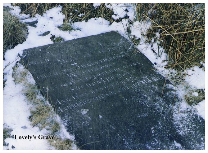
Waterfoot. Nr. Rawtenstall Lancs. Lovely's Grave. Map Ref: 823 211. Situated by a small outcrop just beneath the scarp of Whitaker Pasture , a moorland lying due S of Irwell Valley midway between Cloughfolf & Waterfoot. A small stone slab, set into the wiry turf is carved with the following inscription. "On the twelvth of May
We laid away
One that was loved by many,
She hunted rats and was kind to cats,
And birds she sought out many."
Lovely was 18 years old when she passed away in 1873. A legendary local dog, there is some confusion about her origins.She may have belonged to a local delver or a barber, or a local of the 'San Doyle' public house at Sandy Bank. Certainly it is said that she would go ratting or poaching with anyone who would take her! How it was that she came to rest here is unknown
Wavertree, Liverpool. Map ref:SJ 387 893
On the green in Wavertree village is a curious octagonal Lock up with a pointed roof which dates from 1796.