'Last of the Summer Wine' landscapes, the remains of an iron age hillfort, a Norman castle, and a fine prospect tower make an exciting start to this pleasant walk through pastures and woodlands within a stone's throw of urban Huddersfield.
Getting there: From Huddersfield town centre follow the A629 Sheffield Road for about half a mile. Beyond two sets of lights ascending the hill take filter off to right (signed Almondbury). Proceed up Almondbury Bank, which leads steeply up to Almondbury Village. Just beyond the church turn right into Westgate and passing a fine old half timbered house, follow the lane out of the village, passing through residential area until countryside is reached at Ashes Common Farm (on Left). Continue onwards, passing Castle Hill on the left, until reaching the next junction of roads. Turn left onto Lumb Lane, and about a hundred yards on a narrow metalled lane leads off left, winding up the southern face of Castle Hill to the carpark on the summit. Parking is ample and free!
Distance: 6 Miles. Moderate.
Map Reference: SE 153 141. O.S. Maps: Huddersfield Sheet 102 (1") and Huddersfield & Marsden 1:25, 000 Pathfinder Series.Rating: Walk - *** General Interest - ***
When you get out of your car and wander around the pleasant green sward of Castle Hill, strolling along earthen ramparts and enjoying the fine views of urban Huddersfield below, nestling at the junction of the Colne and Holme Valleys, you will quickly realise that here is a site of great historical significance. Like The Trundle at Goodwood in Sussex, or the famous Maiden Castle in Dorset, Castle Hill is unmistakeably a prehistoric hillfort.
The general consensus among antiquarians is that the earthworks on Castle Hill were constructed around 300 B.C. Covering eight acres, and standing on a 900 ft bluff, the fortifications must have been formidable indeed. The original works consisted of a single stone rampart and a rock cut ditch across the southern end of the hill. Later, the rampart was doubled and extended around the entire hilltop. Finally the whole camp was enclosed by a huge outer earthwork.
That the hillfort was constructed by the Brigantian inhabitants of Iron Age Yorkshire is in no doubt. Beyond that, we must speculate. In Ptolemy's map of the world, which was compiled around AD 160, a place by the name of Camulodunum is shown about fifty miles southwest of Eboracum (York), and it seems possible that Castle Hill was the place to which he referred.
With the conquest of Britain by the Romans, Castle Hill was abandoned. The Romans had their military highway and fort at Slack (See walk 4.), and the fortifications were of no use to them. Throughout the 'Dark Ages' it remained untenanted, until a few years after the Norman Conquest, when the powerful Norman De Lacy Family saw the hill as a ready made site for the construction of a 'motte & bailey' type castle to dominate the surrounding countryside. The castle consisted of three wards, the outer bailey, an inner bailey (where the present Castle Hotel now stands) and an inner ward, where the Jubilee Tower is now situated on the site of the norman keep. To the south of the keep a deep norman well was sunk, which may still be inspected today. The castle was probably erected during the reign of Stephen, but as early as 1340 it is recorded as being ruinous. Its history was fairly uneventful, but it is recorded that in 1307 a jury was set up to investigate certain happenings in the castle, where it was alleged that "a certain stranger had been murdered in the dungeons and his body thrown outside, that his body when discovered was a 'a complete mass of corruption' as if it had been 'devoured by worms, birds and dogs'"
By Elizabethan times the site of the keep had become the site of a beacon. Here was lit the cresset which warned of the sighting of the Spanish Armada in 1588. A contemporary document informs us that:-"Halifax Beacon giveth light to the beacon of Ryney (Reevy) within Bradford, and receiveth light from Castle Hill Beacon nigh Almondbury. It may be seen at Blackstone Edge and Pomfrett." The Napoleonic Wars too, saw the beacon in use, but by the end of the 19th century it had become little more than a memory.
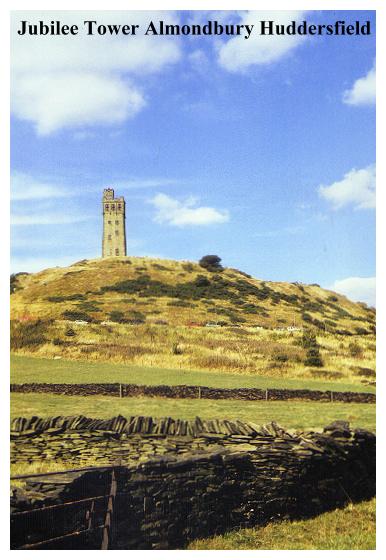
Finally, in 1898 the Victoria (Jubilee) Tower was built on the site, to celebrate the Diamond Jubilee of Queen Victoria. When the foundations for this structure were being dug out in 1897 the dungeons of the old keep were brought to light. Unfortunately they were filled in with rubble and now lie lost beneath tons of heavy victorian masonry. The tower, standing almost 100 feet high, was built by public subscription, the foundation stone being laid by Mr.John Frecheville Ramsden, son of the illustrious Sir John Ramsden, who was responsible for Huddersfield's canal link to the sea. The tower is open to the public on bank holidays and summer weekends, and a small admission charge enables you to enjoy the fine view from the windswept battlements and to browse around the small interpretive museum inside.
Another, more recent, inscription set into the masonry of this tower informs us that:
The lantern on this tower was bought with public subscriptions to an appeal by Huddersfield Civic Society to commemorate the Silver Jubilee of Queen Elizabeth II 1952-1977. Kirklees Metropolitan Council Councillor J. Brooke Mayor
One of the nice things about visiting a folly is being able to pinpoint other follies. Admiring the view from the Jubilee Tower you are spoiled for choice! To the NW the Wainhouse Tower can be seen poking its head out from Calderdale and to the left of that Stoodley Pike Monument is in view. Nearer at hand, above the Colne Valley, the Nab End Tower may be seen on its buttress of rock outcrops. In the opposite direction the Emley Moor Mast is quite unmissable, but a closer scrutiny will be required to pinpoint the Whitley Moor Gazebo.
Now it is time to descend from Castle Hill and to proceed upon our walk. Start from car park by the Castle Hotel. Cross the access road and follow a path along the castle earthworks until a path is seen leading off to the right down the slope. After descending a short distance turn left, following path between hawthorn and holly trees to a stile, beyond which a field path leads down to a lane. Cross lane to a stile opposite then proceed down pasture to another stile. Ignore path leading off right to The Lumb, and continue straight on, descending the pasture to Lumb Lane. Cross to signed stile opposite (near seat) and continue onwards to next hedge. Follow hedge to the right for a short distance, and when the path from The Lumb appears on the right, turn sharp left, descending steps to Molly Bank Wood, crossing Lumb Dike by a plank bridge.
Follow path out of the woods, crossing another field before entering Royd House Wood through a most attractive stone stile. Proceed through woods, crossing a short 'corridor' of pasture before entering more woodlands and crossing a couple of small watercourses. On leaving the woods proceed up the steep pasture, with a scrub choked watercourse on left, to a gate. Bear left, then right, following the track up to Farnley Tyas. On reaching the road, turn right into the village, passing the Golden Cock Inn on the right. Ignore road leading off to Highburton, and continue onwards to the church. Farnley Tyas derives its name from the Tyas Family, who were ancient lords of Woodsome. The name is recorded in the Almondbury area as early as the 13th century. According to one source the name appears as 'Teutonicus' on Latin deeds, which suggests that the Tyas's were a family of German origin. In the 13th century Roger of Notton granted Farnley and Woodsome to Baldwin Tyas, and Sir Baldwin and his heirs were to rule over Farnley and Woodsome for many years, their estates eventually passing to the Finchenden and Kaye Families.
Modern Farnley betrays little of these knightly origins. Its church, unusually dedicated to St. Lucius, was built in 1840. There is a pleasant pub, the Golden Cock, where a drink may be enjoyed whilst sitting in the sun, although the atmosphere seems somehow alien to ramblers.
Just before reaching the church a signed path leads off to the left, down the side of the churchyard. This becomes a track between walls and holly bushes, finally diminishing to a path which enters a metalled lane. Cross to the stile opposite, from which a path leads through a succession of stiles, passing a curious 'Folly' in the arable field to the left before entering Greenside Road at Farnley Moor End.

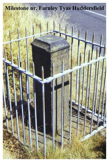
A right turn leads along Green Side Road to a junction of roads, the tall spire of Thurstonland Church now prominently in view.At this junction is a quite unique milestone. The Huddersfield area is well endowed with these old wayside guide stoops, usually carved during the 18th century out of local stone, betraying the fact that the peaceful and remote lanes on which they are generally sited were once major thoroughfares. The guide stoop at Green Side Road End is unusual in that it incorporates a sundial. An appropriate crudely carved inscription informs us that that the Milestone/Sundial was erected by:-
The other faces of the stone, adorned with pointing hands inform us of the distances to Huddersfield, Honley, Holmfirth and 'Pennyftone'.
From the milestone our route leads along Hall-Ing Road to Longley Hill, with fine views of the 'Summer Wine' country opening up before us.descend to the crossroads just below Longley, and continue onwards, passing Royd Farm on the right and descending through housing before entering path into West Wood on the right. Ascend through woods, ignoring paths off to left, until the path enters a pasture, becoming a 'causeyed' path running around the base of Lud Hill. After a succession of stiles the path reaches the head of Ludhill Dyke, and then, after a short series of steps leads through pastures to enter the Honley Road just beyond Glen Farm. Turn left along Honley Road for about a quarter of a mile, before turning right up track to Farnley Hey. Just before reaching buildings, pass through stile on left and follow indistinct path through open fields, following line of trees. On reaching gate near some concrete buildings, continue onwards, bearing slightly right, to a stile in the wall. Do not continue onwards to Castle Houses, but instead turn right, following wall to stile by wood. (Steep ravine in woodland on right.) Continue onwards to gate, and then (with wall on left.) onwards to next field boundary. Turn left up wallside then turn right onto the track which leads from Castle Houses to Lumb Lane. On reaching metalled road turn left, and follow road round face of Castle Hill. Turn right up steps to the Jubilee Tower and a well deserved pint in the Castle Hotel!
Now,tired and sitting in the sun, and no doubt refreshed by a pint from pub, you can relax a little and allow you imagination to wander before you 'up stumps' and risk your car on the steep descent down to Lumb Lane.
There is ample scope for your imagination. We have touched on the sober history of Castle Hill but not at all on the wealth of legends that are attached to it.
Castle Hill is a place of mystery. Its earmarking as the probable site of 'Camulodunum' has raised rather more romantic speculation that it might be the site of Arthur's 'Camelot'. The more sober appraisal suggests that the name was derived from 'Camulos' a Celtic Deity corresponding to Mars, the Roman God of War, but despite this the 'Arthurian Association' exists. According to Camden, who wrote in 1586, Castle Hill was the site of a Roman fort and a Saxon cathedral where Paulinus preached, both of which have been disproved by modern archaeology.
There are, however, stranger stories. Mediaeval sources mention a portion of the hill known as 'Wormcliffe', suggesting the one time existence of a dragon. (From the Anglo Saxon 'wyrm', meaning a dragon.) Dragons in Anglo-Saxon times were associated with death and burial, and it could be that the 'Wormcliffe' in question was in fact an Anglo-Saxon burial ground, where Saxon cinerary urns were adorned with 'wyrm' symbols. of course you could speculate that a dragon (along with King Arthur's Knights), sleeps beneath the hill... but that's up to you!
Needless to say, where there are dragons, there is treasure for them to stand guard over. Children in Almondbury were once rocked to sleep with stories about 't' Golden Cradle'. This treasure is supposed to be hidden in one of Castle Hill's ditches, but no-one seems to know where or why. No doubt it is stashed away in one of the many tunnels which are believed honeycomb the hill. When the 'Castle Tavern' was constructed in 1812 the remains of 'a winding subterranean staircase' were discovered. Whether or not this was explored is not related. It conveniently disappeared beneath the foundations of the pub!!
Legends persist of a great battle fought on Castle Hill, but the origins of this tale are more likely to be found in the long running feud between the Beaumont and Kaye families, which resulted in a bloody skirmish at nearby Hall Bower in 1471, resulting in the death of Nicholas Beaumont of Newsome. The Beaumonts were also involved in the infamous 'Elland Feud' over in Calderdale, a medieval vendetta between local families which piled tragedy upon tragedy..... they must have been hard to get along with!
So, as kids play football, or fly kites, adults picnic or descend on the Castle Hotel. Recently a beacon was lit here for the Armada Celebrations of 1988. In the last century the hill was a venue for the rather less savoury pursuits of dog fighting, cockfighting and bareknuckle prizefighting. Today it is still one of the major recreation areas for the people of Huddersfield. They would be hard put to find a finer one. With velvet turf, a pub, superb sweeping views and a lookout tower, Castle Hill must be one of the the most interesting 'public parks' in England!