Two mysterious follies:- a 'Dumb Steeple' and a 'Devil's Tower', coniferous forest, sweeping views and the remains of coal mining characterise this fine upland walk, the high point (literally), being a 'close encounter' with Yorkshire's greatest 'Prospect Tower'... the Emley Moor TV Transmitter.
Getting there: From Huddersfield follow A629 Sheffield Rd.southwards. Pass The Tolson Museum on the R. And continue onwards to the junction of the Wakefield & Sheffield Roads. Take the left fork, following the A642 Wakefield Road uphill through Lepton. At the crossroads, where the A637 leads off R to Flockton, turn R. onto the B6118 Brighouse Road. Grange Moor is approximately a quarter of a mile along this road. Turn R. and park in village.
Distance: 8 miles approx. A fair hike
Map ref: SE 222 160 Map O.S. Huddersfield Sheet 102 1" Series
Rating: Walk *** General Interest ***
Grange Moor is a pit village of the past. Collieries abound hereabouts on the maps, but find them on the ground if you can! Their existence is simply due to the maps being out of date. Today there are only a few pits left in this area. One is the Denby Grange Colliery, a massive mining undertaking with entrances all around the area, another is Caphouse Colliery, about two miles down the main road, which is now open to the public as the Yorkshire Mining Museum. Otherwise Grange Moor is left alone with its memories.
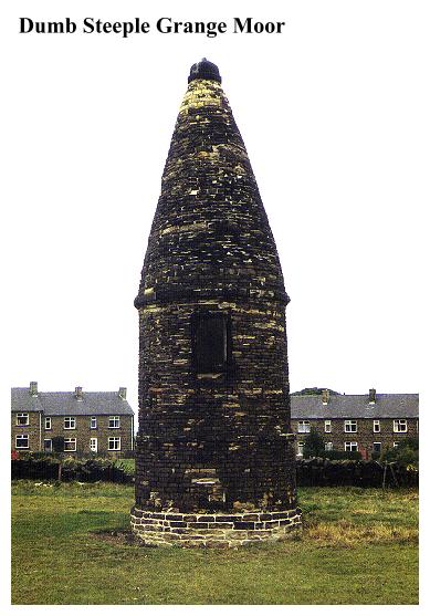
The Dumb Steeple is tucked away in a field behind Grange Moor, surrounded by chicken runs and council houses. The stone slab set into this curious gritstone structure informs us that the landmark was:
There is little else to say. The inscription makes it obvious that there was a 'Dumb Steeple' on this spot prior to 1766, but reveals nothing as to its nature or purpose. That it is a folly is in no doubt, it being an absurdly pointless structure. Richard Beaumont was one of a long line of Beaumonts who were squires of the Whitley Beaumont Estates, centred on Whitley Hall. Perhaps the reason for his building this odd cone was simply that the old one had been struck by lightning and needed replacement. But what then was the purpose of the original Steeple? We can only speculate.
Its curious name may offer some clues. The Dumb Steeple is not unique. There is another 'Dumb Steeple' not too far distant, which stands alongside the busy main road from Brighouse to Mirfield, near Colne Bridge.(See Appendix). This is a well known landmark, being the place from which the Luddites set out to attack Rawfolds Mill during the disturbances of 1812. The general explanation for this 'Dumb Steeple' was that it was built to mark the boundary of Kirklees Park. If we try to probe the meaning of the word 'dumb' we discover that besides its more obvious meanings, it also is a variant of the word 'dummy' or 'sham'- the well known 'folly builder's' expression! So we have a 'sham steeple'- simple enough! There is however, one further possibility. The same dictionary informs us that in American parlance, a 'dummy' is a person who stakes a claim for land on another's behalf. This ties in with the alleged purpose of the Mirfield 'Steeple', so all things considered it seems likely that the Dumb Steeple at Grange Moor was built to mark the boundary of the Whitley Beaumont estates. Perhaps the steeple had some hidden family significance for the Beaumonts, which prompted Squire Richard to rebuild it. We can but speculate.
Here, by Squire Beaumont's Steeple, an oddity of the past stands dwarfed by an oddity of the present:- the Emley Moor Transmitter, which dominates the near horizon. It towers over the landscape, and summons us to kneel in its awesome prescence. Crossing the busy A642 our route leads across fields to Flockton, passing over recently landscaped mine heaps en route. The path descends to the A637, passing the Zion Independent Chapel, which stands aloof from the village in the fields. Built in 1802 this georgian building has a fine five bay front and two symmetrically placed entrances.
From Flockton we head towards Emley Moor. Entering the lane to the West of Emley, the scent of coal fires and sooty chimneypots is carried on the wind. A short road walk and we arrive at the 'viewing area' beneath the Emley Moor Transmitter.
The Emley Moor Transmitter is not open to the public, but if it was it would undoubtedly make a fortune. Its scale is such, that as you plod over the fields towards it, it never seems to get any nearer. You walk, and walk, and then, just as you are beginning to feel that you are never going to get there, it suddenly towers over your head, and you crane your neck back in awe!
The transmitter is owned by the Independent Broadcasting Authority. The traditional BBC presence in the area, the Holme Moss Transmitter is, weather permitting, visible to the west, a tall mast on the inhospitable moorlands around Black Hill. In actuality though, there is no inter channel rivalry, as along with YTV & Channel 4, the Emley Moor Transmitter also puts out BBCs 1 and 2.
Like its western neighbour, the Emley Moor Transmitter was also a mere mast until its sudden collapse in a storm on 15th May 1969, when it partially destroyed a chapel. Consequently it was decided that the new transmitter should be a curved and tapered concrete tower, topped by a steel aerial support mast. Such was the scale of this undertaking that the concrete foundations had to be built down to the sandstone bedrock twenty feet below ground level in order to take the weight of the tower. Work had begun by August 1969 and was completed by November 1970. By 21st January 1971, the transmitter was 'on the air' once more. The transmitter's 'vital statistics' are impressive to say the least. The concrete tower itself is 900 feet high, and the 'Microwave Link Room' and 184 ft aerial mast on top of that pushes the total height up to 1084 ft, which outstrips Blackpool Tower by 516 feet ! The ascent of the tower is by lift and this takes 7 minutes. The 80' diameter of the concrete shell at the base tapers to 21' 3" at the top. The initial thickness of the shell is 21", which gradually thins to a top thickness of 13.5 inches. The tower weighs 11,200 tonnes, the foundations alone weighing 5,400 of them.
The designers of the tower were Ove Arup and Partners, the contractors Tileman & Co Ltd., and one wonders if in future times, their names will echo down the halls of history with those of Henry Flitcroft, John Edward Wainhouse, William Aislabie and John Carr (folly builders all!) We can but wait and see!
From Emley Moor to the A642 above Lepton we must follow tracks and roads, but beyond the Dartmouth Arms there is at least the saving grace of a footpath which passes over a fascinating landscape of gorse and scrub pockmarked by the spoil of early 'bell ground' coal mining activity. Hereabouts the flora seems more reminiscent of North Cornwall than West Yorkshire!
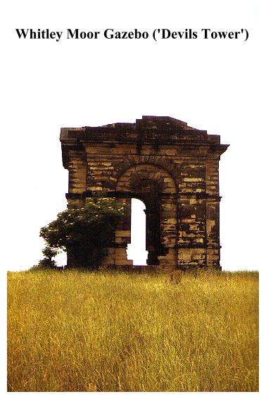
After rejoining the A642 by the Highlander's Sports & Social Club we take to the farm lanes once more, then ascend a wide path leading through coniferous forest. A road leads along the hillside to where a stile gives access to the the edge of a high escarpment on top of which is perched the gaunt ruin of the Whitley Moor Gazebo.
Leastways that's what the guidebooks call it. Two locals I met referred to it as 't'divvle's tower'! If you were to visit this desolate structure on a dark wild day, it would not be hard to find reasons for the epithet. There is something creepy about the Whitley Moor Gazebo, where the raw wind howls through crumbling stones and sightless windows, framed in a soulless web of electricity pylons. Less dramatically, other sources refer to the folly as the 'Temple' or 'The Summer House'. Here are gentler connotations!
Like the Dumb Steeple the Gazebo is associated with the Whitley-Beaumont Estate. According to tradition there is reputedly a 'secret passage' which leads here from Whitley Hall. Another legend says that when 'Black Dick' Beaumont was born in 1574, a cask of wine was hidden in the tunnel to be opened on his 21st Birthday. 'Secret passages' smacks of priest holes, and the sixteenth century persecution of Catholic 'recusants', but I'm afraid I'm going to have to disappoint the romantics:- the gazebo was built around 1740, as its distinctively neo-classical architecture testifies.
The most striking architectural feature of the gazebo is the fact that it once had a deep, brick lined basement. The original floor of the summer house has gone, and the entrance door leads straight onto an eight foot drop, to piles of rubble below. This was almost certainly a wine cellar, access to it being through a door in the foundations. During the miner's strike of 1926, this basement was apparently used as a 'day hole'. Being already set deep into the ground, it would have been a simple matter to take up its floor and dig out the coal seam beneath. What this must have done to the foundations of the gazebo doesn't bear thinking about. The existence of the 'passage to Whitley Hall' legend is undoubtedly due to the prescence of this mysterious basement/'dayhole'.
It is said you can see York Minster from the Gazebo. Certainly you can see everything else. The Jubilee Tower on Castle Hill stands opposite, and there are fine views to the High Pennines with Holme Moss towering over the Huddersfield Valleys, close by the Derbyshire/Cheshire border. To the North West, the South Pennine Moors around Hebden Bridge are visible, with a distant Stoodley Pike, and nearer at hand are the hills around Halifax, with the Wainhouse Tower poking up from the slopes of the Calder Valley. A distant white speck in the midst of the moors beyond Halifax marks the Withens Hotel, which, since the boundary re-organisation thrust the Tan Hill Inn into the neighbouring county, has claimed the title of 'Yorkshire's Highest Inn'. The hilltop settlement to the right of it, which towers over the Calderdale moors, is Queensbury, high above Bradford, and the adjacent cone of trees with the small radio mast marks the summit of Horton Bank Top, Bradford's 'Reevy Beacon'. To the North East, the Dales are just in view with the moors around Almscliff Crag and Washburndale clearly visible. To the East lies the urban sprawl of the Heavy Woollen District around Dewsbury and beyond, the rolling urban landscapes of Greater Leeds. South east, and the view simply disappears into the cooling tower generated haze of lowland Yorkshire.To the South is Emley Moor. The walk back to Grange Moor is interesting and pleasant enough, if confusing. A whole range of countryside between here and the venerable village of Thornhill is worthy of exploration, but by now you will be thinking of rest for aching limbs, so you will be uninclined to wander further. If, when you have relaxed and refreshed yourself, you still have a thirst for exploration, the Yorkshire Mining Museum is just down the road. Here you can make up for not being allowed up Emley Moor by descending a mine shaft which is as deep as Blackpool Tower is high. The Guide there, Geoff, is an old friend of mine, who, when not guiding you around the maze of underground 'main gates' and 'tail gates', and drawing on his long experience as a miner, follows country music with sixguns and stetson! The museum puts the mining history of the area into a very real perspective. If you've ever wondered how coal was (and is) won, at Caphouse you will find the answer. The upland area between Huddersfield, Denby Dale, Dewsbury and Wakefield has long been an 'off-the-beaten-track' region, a semi rural backwater of upland pastures, red brick hamlets, spoil heaps and collieries. Hardly a place to attract ramblers you might say. Could it be we are about to witness a change? Already the Kirklees Way comes through this area, and the maps betray a multiplicity of footpaths leading through woodland, hill and dale. The scope for the walker in this fine upland area has yet to be fully exploited. The purist in me hopes that it will be spared the mushrooming of waymarks, footpath signs, interpretive centres, and all the other paraphernalia of 'countryside biz', which in trying to cater for the needs of the public, runs the risk of damaging the character of the very landscape it is trying to promote. My advice is this:- come here, do this walk, but the next time you come:- go your own way.........