14. COOK MONUMENT & ROSEBERRY TOPPING
An obelisk erected to the memory of Britain's most famous explorer, coastal views over Teeside, a folly in the guise of shooting hut and the lofty cone of Roseberry Topping are all visited on this upland ramble on the northern fringe of the North Yorkshire Moors National Park.
Getting there: From Thirsk follow A19 northwards to its junction with the A172 near Ingleby Arncliffe. Follow A172 to Stokesley then A173 to Great Ayton. At Great Ayton turn R. and follow road through village signed 'to Station'. After crossing railway continue onwards past station along Dikes Lane. Beyond a crossroads the lane leads up to Gribdale Terrace and then winds steeply to the left before ascending to the cattle grid at Gribdale Gate. Here there is ample parking and access to a number of well trodden footpaths.
Distance: 6 miles. Lots of ascent and descent!
Map Ref.: NZ 593 110 O.S. Outdoor Leisure 26. North Yorkshire Moors (western area) 1:25 000
Rating: Walk:*** General Interest: ***
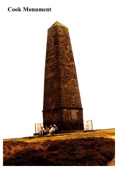
The Cook Monument is the northernmost of the follies visited in this book. Southwards are the Cleveland Hills, with the high scarp of Cringle End particularly in view. This is where upland North Yorkshire falls away to the flat, industrialised coastal plain of Teesside. The Cleveland Hills, (gradually giving way to the high level moorland plateau of the North Yorkshire Moors beyond Hasty Bank), form the main upland massif of this area, Roseberry Topping and its surrounding hills being mere outliers.
From the parking area by the cattle grid at Gribdale Gate an obvious and wide track (signed 'Cleveland Way') leads up through a pine forest onto Easby Moor and proceeds without complication to the Cook Monument.
An iron fence surrounds the Cook Monument, beyond which a plaque bears the following information:-
IN MEMORY OF
THE CELEBRATED CIRCUMNAVIGATOR
Capt. JAMES COOK F.R.S.
A MAN IN NAUTICAL KNOWLEDGE INFERIOR TO NONE
IN ZEAL,PRUDENCE AND ENERGY SUPERIOR TO MOST
REGARDLESS OF DANGER HE OPENED AN INTERCOURSE
WITH THE FRIENDLY ISLES AND OTHER PARTS
OF THE SOUTHERN HEMISPHERE.
HE WAS BORN AT MARTON OCT.27TH 1728
AND MASSACRED AT OWYHEE FEB 14th 1779
TO THE INEXPRESSIBLE GRIEF OF HIS COUNTRYMEN.
WHILE THE ART OF NAVIGATION SHALL BE CULTIVATED
AMONG MEN,WHILE THE SPIRIT OF ENTERPRISE,
COMMERCE AND PHILANTHROPY SHALL ANIMATE THE
SONS OF BRITAIN, WHILE IT SHALL BE DEEMED
THE HONOUR OF A CHRISTIAN NATION TO SPREAD
CIVILISATION AND THE BLESSINGS OF THE
CHRISTIAN FAITH AMONG PAGAN AND SAVAGE TRIBES,
SO LONG WILL THE NAME OF CAPTAIN COOK
STAND OUT AMONG THE MOST CELEBRATED
AND MOST ADMIRED BENEFACTORS OF THE HUMAN RACE.
As a token of respect for
and admiration of that great man
this monument was erected by
ROBERT CAMPION ESQUIRE OF WHITBY.
AD 1827.
By permission of the owner of the Easby Estate,
J.J. EMERSON ESQR. it was restored
in 1895, by the readers of the
NORTH EASTERN DAILY GAZETTE.
The story of James Cook is a stirring one. As the plaque tells us, he was born in Great Ayton and went to school there, working on his father's farm until the age of 17 when he became apprenticed to a grocer in Staithes. Cook was not happy there and in July 1746, helped by his master, he was apprenticed to John and Henry Walker of Whitby...Shipowners.
Cook never looked back. His first two years at sea were spent on the collier brig Freelove trading between Newcastle and London. Within a few years he had become mate of the another Walker ship, the Friendship, and in 1755 he was offered command of this ship.
Cook's response was to join the navy as an ordinary seaman! War was imminent and he felt that prospects for naval promotion looked good. He was right. He served on HMS Eagle and within a month had become Master's Mate and his career was underway .
Cook was involved in colonial wars against the French, and while in Canada charted the St. Laurence and Newfoundland and earned a reputation as a gifted and meticulous cartographer and an able and zealous commander. In 1762 he married Elizabeth Batts at Barking. He was 34 and she 21. Now a warrant officer, he took up residence in London.
While serving in Canada in 1766 Cook made a detailed report of a solar eclipse he had observed off Newfoundland. This was published by the Royal Society, and brought his name to the notice of men of science. By the tender age of 40 Cook was poised on the threshold of his career. He never could have realised the sheer enormity of whap he was about to acheive.
At this time there was a great interest in astronomy. It was known in scientific circles that Venus would pass between the Earth and the Sun on 3rd June 1769, a once a century event. In order to broaden astronomical (and consequently navigational) knowledge and to help with the calculation of the earth's distance from the sun, The Royal Society proposed an expedition be set up to observe this 'transit'. To make the necessary calculations the transit would have to be observed from three points:- The North Cape at the Arctic tip of Scandinavia, Fort Churchill on Hudson's Bay, Canada, and an island in the South Pacific- an area then relatively unknown to navigators. Two competent observers were to be sent to each location. Recommended by his former commander, Hugh Palliser, Cook got command of the South Seas expedition and in March 1768 the navy bought and fitted out the barque Countess of Pembroke, a Whitby built ship. She was renamed The Endeavour. Cook's voyages of discovery had begun.
Cook made three voyages to the South Seas. His first voyage, in the Endeavour, lasted from 1768 to 1771. The Endeavour put to sea with a group of artists, botanists and astronomers on board. It was, in effect the first ever serious scientific expedition. The chief botanist on board was Joseph Banks, and he and Cook became firm friends.
On this voyage Cook visited Tahiti, mapped the coast of New Zealand (which was then believed to be a continent!) and explored the coast of New Holland (now New South Wales). Cook kept his crew in good health and free from scurvy by making them eat sauerkraut and onions! It worked! After sailing all over the Pacific in robust good health, many of the party were fated to die of malaria contracted in the Dutch East Indies on the way home...but nobody got scurvy! Cook and Banks returned to England to a heroes' welcome.
Cook's second voyage lasted from 1772 to 1775. This time, his task was to circumnavigate the high Antarctic latitudes in search of 'The Great Southern Continent' which it was believed existed there. Two sturdy Whitby ships, the Marquis of Granby and The Marquis of Rockingham were appropriated by Cook for the task. These were to be renamed Drake andRaleigh, but in the end sailed as the Resolution and the Adventure.
Cook commanded the Resolution (Adventure being commanded by Captain Tobias Furneaux) and Banks was invited to lead the botanists, but success had gone to his head and he had lost all sense of proportion. He insisted on redesigning the Resolution to his own specification, which had the effect of rendering the vessel unseaworthy. (He had added an extra deck to the ship to accomodate his party- which made it top heavy!) In the end Banks was rebuffed by the Navy and Cook had the Resolution was restored to its original dimensions. So great was Cook's reputation for keeping 'a happy ship' that almost all of the seamen who had sailed on the first expedition wasted no time in signing up for the second. (Perhaps it also had something to do with the rather more dubious attractions of South Sea Vahines!!)
The expedition sailed from Plymouth on 27th June 1772. Among the ship's midshipmen were George Vancouver (later to earn fame charting the western coasts of Canada) and Dr. Charles Burney, brother of Fanny Burney, the famous actress. Cook sailed south to the Antarctic Circle and visited New Zealand, Tahiti, Tonga and Easter Island. The Resolution circumnavigated the globe in the high southern latitudes in a vain search for the elusive 'Southern Continent'. The only land Cook encountered was South Georgia, which led him to the conclusion that if there was any sort of 'Southern Continent' then it must lie beneath the thick ice at the South Pole itself. On returning to New Zealand Cook discovered that the Adventure had sailed back to England after an incident which had resulted in some members of Furneaux's crew being killed and eaten by the Maoris. Cook followed in his wake. The Resolution dropped anchor at Spithead on 30th July 1775. The voyage had taken three years and 18 days, and in that time Cook had lost only four men, only one of whom had succumbed to sickness! The Resolution had also gained an extra crew member:- Omai, Cook's Tahitian friend, who had decided that he would come and see this 'England' for himself. Needless to say, Omai was an instant celebrity, and he travelled everywhere, even visiting Great Ayton with Cook. How the bleak landscape of the North Yorkshire Moors must have appeared to this tall, bronzed Polynesian is not recorded.
Cook's third voyage was his last. Once again he sailed in the Resolution, laden with honours and good wishes, quite unaware of the fateful consequences which lay ahead for him. Omai returned to his native Tahiti with fabulous stories about life in Europe, and Cook continued on his explorations. But for some reason Cook had changed. He seemed to lack that steely determination with which he had sailed through the hardships of the icy southern latitudes in pursuit of a mere geographical speculation. On his third voyage was inclined to dally, to succumb to the temptations of the South Sea Islands, where in the eyes of the natives he was almost a God. It was that deification which was to cost him his life. As with all living 'deities' there is always somebody ready to disprove divinity by the expedient of assassination. Cook failed to to appreciate the true nature of the local political upheaval his visits had precipitated. In short, during sudden difficulties in Hawaii, he was forced to beat a retreat, and, urging his men to the boats, made the fatal mistake of turning his back on the natives, who would never have dared to challenge this 'god' face to face. Cook was struck from behind, and seeing him fall, the Hawaiians fell on him with their spears and cut him to pieces. Such was the tragic end of James Cook.
Cook's sons, like their father, were also fated to die at sea, far way from home. Mrs Cook, however, outlived them all, and died at a ripe old age. Cook himself had passed on to immortality.
Today, Cook's memory is enshrined all over North Eastern Yorkshire. His statue stands above the Whitby Harbour he knew so well, and here, on Easby Moor, is his monument. It is not unique. On the contrary, it is said that more obelisks were built to honour Cook than for any other historical personage! They are numerous throughout the world:- particularly in the Southern Hemisphere. In England, at Chalfont St. Giles, a 'Cook' column topped by a globe is sheltered by a castellated arch. This was built by Sir Hugh Palliser in memory of his friend. Great Ayton now builds its tourist industry on its association with Cook. The tiny pantiled cottage which was built by Cook's father, who had carved his initials and those of his wife over the door, suffered the dubious distinction of being taken down brick by brick and rebuilt in Australia in 1934. In its place Great Ayton got an obelisk- a replica of one sited on Point Hicks, the first bit of Australian Coast sighted by Cook. The obelisk is built of stone hewn from Point Hicks, but one cannot help but think that Great Ayton got the worst of the deal!!
From the monument our walk is a steep descent through forest towards Dikes Lane. Bear right, descending slightly, to two stone gate stoops on the edge of the hill. Continue onwards until the wall bears 90 deg. left down to the forest. Ignore a path continuing along the moor and descend diagonally left to enter a conifer plantation through the remains of a handgate.
The path descends steeply through the plantation and crosses a broad track before leaving the forest through another gate.
Entering open pasture, follow the wall downhill for a few yards, then turn right, following a wall to where a stile gives access to a pleasant path between hedgerows, which passes a small wood on the right, becoming a metalled lane leading from Cherry Garth. The lane leads without complication to the junction of Dikes Lane and Aireyholme Lane.
Hereabouts There are remains of extensive mining and quarrying still to be seen. Mining has been carried out in these hills since the 1760's right through to the 1920's. Alum, jet, iron ore, roadstone and building stone have all been exploited at one time or another. Today the spoil heaps, adits and tramways stand derelict and overgrown.
Leaving the crossroads at Dikes Lane, continue onwards along Aireyholme Lane, winding up the hillside to Aireyholme Farm,(where Cook lived for a few years) which appears on the left. Bear left through the farmyard, and at a junction of paths,ignore the track leading right towards Roseberry Topping, and instead continue onwards, following the track towards Aireyholme Cottage.
Join the footpath, which passes to the left of Aireyholme Cottage, and just beyond, a stile in the wall gives access to a path which leads down the edge of two fields beyond which bear left up a gorse covered bank to The Shooting Box .
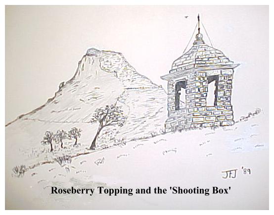
Now Roseberry Topping looms large, but before ascending, let us stop awhile and examine this second 'folly' on our walk, which stands on a grassy terrace, almost at the foot of the conical 'Topping'.
The Shooting Box is less like a shooting box than can be imagined. It looks more like a gazebo. A plaque attached to it explains both its origin and its function. "The building was commissioned by Commodore Wilson of Ayton Hall in the late 18th century as a shelter at lunchtimes and during inclement weather during shooting. It was restored in 1983 with assistance from the North Yorks Moors National Park Committee." Nowadays it shelters cold, wet hikers rather than grouse shooters.
So we come to Roseberry Topping. From the Shooting Box, follow the obvious (and eroded) path to the summit of Roseberry Topping. (If you wish to avoid the ascent, simply follow the path alongside the fence which runs around Roseberry's lower flanks.)
The ascent is steep, but the view from its rock crested summit is breathtaking. The full extent of industrial Teeside lies beneath our gaze, as is the sea, and our eyes can follow the shoreline up towards Hartlepool. To the west, the Pennine Dales are in view, beyond the Vale of Mowbray. Roseberry Topping's conical form is not entirely due to natural forces. Standing at 1057 feet above sea level, the hill has been extensively quarried for stone, which has contributed much towards its present shape.
From Roseberry Topping descend to rejoin the alternative path by the fence. Continue onwards into a dip to where a footpath crosses the path by a National Trust sign. Press onwards over Roseberry Common, passing the remains of old mine workings on the left. After ascending steeply, the path bears right to a handgate in a wall hard by a plantation (Signed 'Cleveland Way'), beyond which prehistoric tumuli come into view. There are reputedly over 10,000 round barrows and ancient cairns up here amongst the dark heather, bracken and bents grass. There are prehistoric hut clusters, earthworks, standing stones and stone circles. The 10,000 square miles of the North Yorkshire Moors upland plateau must surely constitute the most unspoilt monument to the activities of prehistoric man in Northern England. The place name element 'Howe' denotes the burial places of these ancient chieftains, and if you take a glance at any horizon to the SE of Roseberry Topping you will see the tiny bumps on the skyline that betray their presence. 'Loose Howe'... 'Flat Howe'.... the landscape (and the map!) is studded with them.
Now follow the obvious (and mercifully level) path which leads alongside a plantation (conifers on right, open moorland on left.). After some distance the path forks. Take the right fork, descending steeply down to the road via a series of steps. Bear right to the cattle grid and the start of the walk.
By the time you get back to your car you will be tired, and inclined to sample the hospitality of Great Ayton. If however, the weather is clear, the kids will have seen 'the sea' from Roseberry Topping, and so you will be more likely to finish up on the pier in nearby Saltburn! Whatever the case, it will have been a good end to a good day, and your inclination will be to return and to explore further.If you would like to discover the character of the moors on a more intimate (and adventurous!) basis there is always The Lyke Wake Walk!