16. THE CARNABY TEMPLE
Fine coastal views, two contrasting churches, an 18th century temple, a roman highway, a fine country house, a gazebo and a mysterious dry river bed are the attractions of this gentle Wolds walk to the valley of the Gypsey Race.
Getting there: Carnaby stands just outside Bridlington on the busy A166. There are lots of narrow lanes in Carnaby, but no car park. You will have to use your imagination (I parked next to the forecourt of a haulage contractor's yard!). Another option might be to come out by bus from nearby Bridlington, where there is ample parking... but free parking in 'Brid' is virtually non-existent!
Distance: 3 Miles. Easy. Take the kids!
Map Ref.: TA 148 655 Sheet 101 Landranger. 'Scarborough & Bridlington.' 1:50 000
Rating: Walk *** General Interest ***
Walk a few yards from the bustling artery of communication which slices mercilessly through the heart of Carnaby, and you will find a lazy, sleepy, gentle wolds community. Although much of the area to the south of the village is now given over to industrial estates, on the periphery of the former Carnaby Airfield, built in 1944, the traditional nucleus of Carnaby still retains its rural charm.
Just 2 miles from Bridlington, Carnaby is one of a string of villages which stand at the base of of the Wolds,on the northern edge of the coastal lowlands of Holderness. Our route proceeds along Temple Lane, and within a very short distance we find ourselves climbing up onto the Wold with fine views of the Holderness coastline opening up behind us. Around Temple Farm, the soil is a rich arable brown, laden with fragments of chalk. Prior to the enclosures of the 18th century many of these vast arable spaces were filled with the open field strips of the parish, while the low lying Holderness land to the south of the parish was largely moorland and scrub.
From the main road, proceed up Temple Lane to Temple Farm. Pass farm buildings on the left to reach the Carnaby Temple in the field ahead.
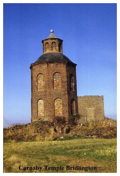
The Carnaby Temple is quite unmistakeable. It crowns the summit of the wold, and from it there are extensive views. To the right, Flamborough Head with its lighthouse is just visible. This octagonal red brick tower, two storeys high and containing a basement, was built by our old friend John Carr for Sir George Strickland in the late 18th century. Probably built as a lookout tower, it was based on the Temple of the Four Winds in Athens. The four windows of the temple (now bricked up) faced the cardinal points of the compass. From the centre of the roof rises an octagonal brick cupola, crowned by a leaden ball finial. Inside, I am informed, there were once attractive frescoes dating from 1771. The chimney stack and extension were apparently added at a later date when the building was used by farm labourers. Eventually it became a storehouse, and then, after being used in the last war by the military for an undisclosed purpose, it eventually fell into dereliction.
The name Strickland is writ large hereabouts. As lords of the manor up to 1950, and owners of nearby Boynton Hall, they were to this part of the Wolds what the Sykes Family were to Sledmere, although on a rather less grand scale.
Beyond the Carnaby Temple we continue onwards across an arable field following a line of electricity poles to join tarmac at the Wold Gate, which marks the northern boundary of Carnaby Parish. This is a very ancient thoroughfare, being in fact a part of the old Roman road system connecting York to Bridlington via Stamford Bridge. Looking at this backwater of a lane, descending the wold towards Bridlington in a long straight line with verges at either side, this is not hard to imagine. There were in fact, two Roman highways heading for Bridlington on either side of the Rudston Valley (which is the vale before us). The northern road was the High Street, which ran through Rudston, Swaythorpe and Sledmere. Our road, (the southern branch) was known as The Low Street, and led westwards to Kilham and then onwards along Green Lane past Sir Tatton's Monument.
Regarding the Roman significance of Bridlington, very little is known. Bridlington Bay is a natural haven and there would almost certainly have been some kind of landing place there. Roman pottery and coins have been found in Bridlington, some of them on the beach. Remains of a paved road discovered near Sewerby suggests that it might have led to a signal station on Flamborough Head. The original Roman harbour at Bridlington, (if there was one) is almost certainly beneath the sea, having long ago succumbed to that gnawing erosion that ravages the Holderness coast. Very likely there was a fort or military base there also, although no Roman buildings have ever been traced. The mediaeval harbour which preceded Bridlington Quay was known as Castleburn. Perhaps this referred to our hypothetical roman fort.
The Romans were not of course, the first inhabitants of the area. Before (and during) their coming, this was the homeland of the celtic Parisii (the same tribe that gave their name to modern Paris) and their burial sites and numerous defensive earthworks may be found all over the wolds, particularly in the vicinity of these ancient thoroughfares. Around nearby Rudston prehistoric remains are numerous, and the mysterious Argam Dykes are second only to the even more ancient and mysterious Rudston Monolith, that enormous pagan phallic symbol which towers malevolently above nearby Rudston Church.
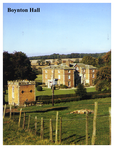
Cross Wold Gate to a stile opposite (signed) and proceed down another arable field to the boundary of Boynton Hall's parkland. Bear left, following the perimeter fence round to a stile. Descend pasture to the next stile (rear of Boynton Hall visible on right) beyond which a grassy track leads right, past a pig farm (on left) to the Boynton Hall Gazebo, beyond which lies the lovely mansion of Boynton Hall.
Unlike Sledmere, the whole area of Boynton seems much less 'private' and its charms may be enjoyed at a relatively close range. Turning the corner by the farm, the first thing to catch our attention is Boynton Hall's Gazebo. This castellated red brick structure was built in the 16th century, but around 1770 - at the same time as the construction of the Carnaby Temple - it was given a 'facelift', acquiring its present Gothic features.
Boynton Hall itself has undergone similar 'facelifts'. The original house was built in the late 16th century, probably by William Strickland (of whom more shortly), or his son Walter. It was from the outset a three storeyed building,being built of red brick and stone plundered from Bridlington Priory. In 1674 the house was described as having '23 hearths' (Such records exist because at the time you had to pay a tax on each one!). The exterior of the house was extensively altered during the 1730's by Sir William Strickland (d.1735), but much of the earlier work was left inside the new classical facade. The stone mullions of an earlier age disappeared during this alteration and were replaced by sash windows. Towards the end of the 18th century the house was altered for a third time, when John Carr was employed for the task. This time the house was given a total facelift, which completely altered the original House, and added a range of outbuildings; giving it the appearance it retains to this day. This intensive work was carried out between 1765 and 1780. Today, Boynton Hall is now occupied as flats, but its charm and grace remain.
Passing around the front of the hall we come to a series of ornamental bridges over the Gypsey Race. I am told the 'G' in 'Gypsey is 'hard', but I have never heard it pronounced so, even by people whom one would expect to know. The romantic sound of the name, along with the decisive blue line with which it is depicted on the maps, might suggest to the outsider that it is a sprightly babbling rill. If so you are in for a disappointment ..... the bed of the Gypsey Race is usually dry!
The Gypsey Race is, in fact, one of the most curious watercourses in Britain, having a hydrology that is uniquely its own! To say that it is an 'elusive stream' is putting it mildly! Once upon a time, long before the advent of the glaciers of the last Ice Age, the Gypsey Race was known as the River Ure! Flowing from Wensleydale, the Rudston Valley was its way out to the sea! Needless to say, things have changed a bit since then. The Gypsey Race rises between Wharram-Le-Street and Duggleby, flows northwards a short distance and then eastwards for 22 miles, passing through Rudston and Boynton to enter the sea at Bridlington Harbour. For some of its course it runs as a stream, but mostly it runs underground, leaving a dry riverbed on the surface.
The name 'Gypsey Race' is believed to be derived from the Norse 'gypa' meaning spring (the word 'geyser' comes from the same source). Its curious character is due to the porous nature of the underlying chalk, which allows the formation of natural underground reservoirs. When the water table rises, water is siphoned up to the surface, and the normally dry riverbed becomes an angry torrent. Strangely enough, although not surprising considering the contrary nature of the Gypsey Race, this sudden eruption of water is more likely to take place after a dry season than a wet one!
Ignore the first bridge over the Gipsey Race (usually dry!) and bear right (passing front of Boynton Hall) to a second bridge. Bear left down the road to entrance gates and Boynton Church.
When I was here, Boynton Church was beautifully decked out with flowers, and fruit, ready for Hawker's Harvest Festival and the whole building was a rage of colour. The Church of St. Andrew stands to the south of the village, by the entrance gate to Boynton Hall. Of the original church, only the tower remains, the rest of the building having been rebuilt in brick sometime around 1768. The tower, dating from the 15th century has perpendicular windows and crocketed pinnacles. Little is known of the old church. In the late 16th century the chancel was reported to be 'in wonderful great decay' and quite unusable in winter. No doubt it remained so until its rebuilding. The 18th century church is a masterpiece. Where one expects a chancel arch there are instead two massive classical pillars, and the whole interior is painted a pastel green. A flight of steps leads from the nave at the west end of the church to a fine gallery. The east window contains stained glass of 1768 by William Peckitt of York. The whole atmosphere is one of 18th century charm, elegance and classical grandeur.
The church was again altered around 1910, the old box pews being replaced by modern style seating, facing east. An old sepia photograph on the wall depicts the condition of this church prior to the restoration.
The church is filled with monuments to the Stricklands. Boynton's most famous curiosity is the Turkey Lectern which depicts 'a turkey in its pride proper'. This turkey is the Strickland family crest, and must surely be the most unusual heraldic device in the land. The origin of the 'Strickland Turkey' is even more fascinating. Sir William Strickland (who built the first house), had this crest and coat-of-arms granted to him in 1550 after having sailed from Bristol with the Cabots on an expedition to the Americas in pursuit of gold. Unfortunately all he managed to bring back was a number of turkeys, which nevertheless, having never been seen before, excited much interest. So next time you eat your christmas turkey, spare a thought for Sir William Strickland of Boynton, who first introduced this gaudy bird to our shores!
Another monument commemorates a later (17th century) William Strickland, who, although knighted by Charles I, took up the cause of Parliament in the Great Civil War. After landing at Bridlington, under fire, Charles's Queen, Henrietta Maria, sought sanctuary at Boynton on her way to York. She received a courteous but cold welcome.
From Boynton our route leads back uphill to the Wold Gate. Beyond the church turn left, following a track through houses (signed 'Public Bridleway'). Bearing left,ignore a footpath leading off through houses and follow the main track. This leads back through trees to yet another bridge across the Gipsey Race (This time single arched with railings.). Continue onwards, passing same farm buildings encountered on the way in. (The route back passes to the right of the farm buildings.)
Beyond a small house the track leads up through plantations back to the Wold Gate. Cross the road and continue onwards, the bridleway becoming a long straight 'tunnel' through overhanging trees.
On reaching the tarmac road turn left and follow the lane back to Carnaby, which descends the hillside, entering the village by the Church.
The Church of St. John The Baptist Carnaby, is a curious structure. It is like Boynton Church's 'poor relation'. Approaching the tower, there is a feeling of 'dÑja vu' until it suddenly occurs that this tower is a virtual clone of the church tower just seen over at Boynton. It seems likely in fact, that they were both designed by the same mediaeval architect.
Though less grandiose than its neighbour over the hill, I personally found Carnaby Church more intriguing. The first thing one notices on entering, is that there is in effect only 'half a church'. The mediaeval South Aisle remains but the whole north wall of the church consists entirely of 18th century brickwork! In the 16th & 17th centuries Carnaby Church was reported to be in a ruinous condition, like its neighbour at Boynton, but being no doubt of secondary importance to the Stricklands, instead of rebuilding the church, they simply 'patched it up' and this is the result! Restoration of the chancel began around 1680, and by 1719 it had been rebuilt in brick 'in the coarsest style'. In 1830 the original south porch was removed, the aisle was reroofed and the brick clerestory added. New windows were inserted in the north wall. The latest restoration was in 1966 when the slate roof was replaced by tiles, and a new ceiling was put into the nave.
Underlying this mish mash of brickwork, tiles and timber is the original mediaeval church! The tower is 15th century, but its arch is of 13th century date, as is the south aisle, and the aisle arcade. By far the oldest artefact in the church is its ancient font. Norman fonts are fascinating; there always seems to be something distinctly pagan about them. The lozenge pattern on this one seems faintly reminiscent of the staring faces usually depicted on objects pulled out of prehistoric burial mounds on the wolds (The tiny chalk 'Folkton Drums' in the Hull Museum being a good example). Carved on the fabric of the church, both inside and out are other 'odd' patterns, which seem to have an affinity with the lozenges on the font! We can only speculate as to their meaning and purpose, which could be anything from 'witch marks' to games played by victorian schoolchildren!.
Other carvings are less mysterious. An old coffin lid is built into the south wall, and there is a carved 'mass dial' which was used before the advent of church clocks. But perhaps the most interesting inscription is carved on a pier in the south arcade:-
HIC JACET / CORPVS W / ALTERI VPPI / BI HVMATUM
CUIUS ANIMAM ABSOLVAT DEUS
It does not take a great command of latin to realise that the inscription marks the last resting place of Walter Uppiby, who was laid to rest here in the early 14th century. The name is an unusual one, but it is recorded that the Uppiby Family held land hereabouts around this time.
The earliest reference to Carnaby Church was sometime around 1148 when it was granted by Robert De Percy to the Prior of Bridlington. Carnaby's association with the powerful Percy Family made it a place of some importance in those distant times. On June 3rd 1299 another Robert De Percy obtained a grant to hold a weekly market on Thursdays at his 'Manor of Kernetteby'. This right is perpetuated in the modern cross which stands at the bottom of School Hill. It is inscribed 'Carnaby mediaeval market stone. Reconstructed 1968'.
So, as we approach the bustling main road, we have reached the end of our journey. Only one 'monument' remains to be discovered in Carnaby, but I must confess I did not see it. (Perhaps it is no more, because the source of my information dates from 1892!). In a garden somewhere in the village stands a small column which was erected by Mr. H. Robinson Esq., in honour of Melbourne, a famous racehorse which was bred there in 1830. Find it if you can!!!