4. HARTSHEAD PIKE MOSSLEY
A quaint old pub. An overgrown reservoir and a highly distinctive folly tower characterise this fine walk with sweeping views over Oldham and Greater Manchester.
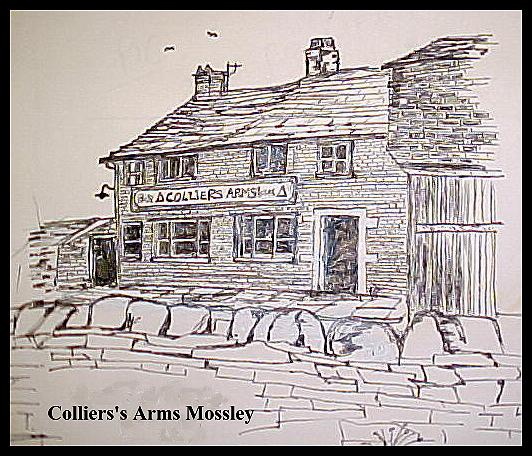
Getting There: From Oldham (Mumps Roundabout) follow A669 to Grotton. At junction turn right onto A6050 towards Mossley, joining the A670 coming in on the left. Follow A670 uphill past Mossley, and just beyond the church on Mossley Brow, turn sharp left onto Broad Carr Lane. Turn left onto a rough track and park by the Colliers Arms.
Distance: 3 Miles (easy)
Map ref: SD962 026 Landranger 109 or Peak District Tourist Map.
Rating: Walk - ** Follies and General Interest - **
On Owdham Edge the grass is green,
Reetest view that ere thas seen.
Tha stands on ttop an tha looks abeawt,
Thers nowt but mills wi ther chimney spouts
Old Song.
Hartshead Pike has a character all its own. Situated on an upthrust of land between Mossley and Southern Oldham, it crowns the last gasp of the Pennines, standing at the point where the hills give way to the low lying industrial landscapes of Greater Manchester. The distinctive red brick chimneys and dominating hulks of Lancashires redundant cotton mills are also in evidence, though not now so numerous and all-pervading as when Lowry captured their character for all time.
East of Hartshead Pike lies Mossley and the Tame Valley leading Northwards to Uppermill. This area, generally known as Saddleworth, is a finger of gritstone Yorkshire protruding into red brick Lancashire. Eastwards of Mossley the hills rise steeply into the bleak moors of the Pennine Watershed, but here at Hartshead Pike the landscape is hilly yet rather more subdued.
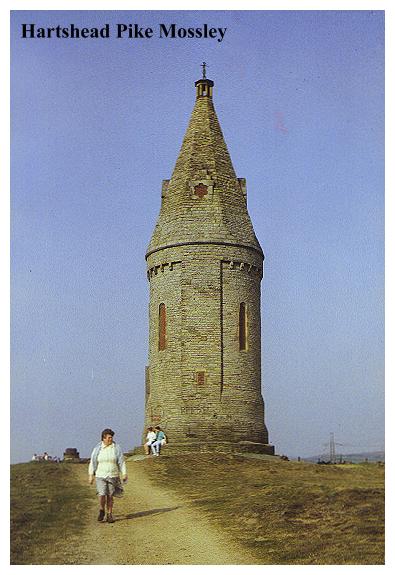
Hartshead Pike, sometimes known as Heartshead Pike or Tower, is a tall, circular building with a conical roof. It was originally intended to be 85 feet high, but no doubt sights had to be lowered when the bills began to come in. The towers history is chronicled by a number of inscriptions.
Look well at me before you go
And mind ye nothing at me throw
This Pike was Rebuilt By
Pub-lick Contribution Anno Do:
1751
AND
RE-ERECTED
BY PUBLIC SUBSCRIPTION
TO COMMEMORATE THE MARRIAGE OF
H.R.H. ALBERT EDWARD, PRINCE OF WALES
TO H.R.H THE PRINCESS ALEXANDRA OF DENMARK
And to restore
THE ANCIENT LANDMARK OF
HARTSHEAD PIKE
THE RT.HON. GEORGE HARRY 7TH EARL OF
STAMFORD AND WARRINGTON
BEING LORD OF THE MANOR ARTHUR F PAYNE ESQUIRE STEWARD
THE FOUNDATION STONE WAS LAID BY SAMUEL DUNCUFT LEES
M.D.
MAYOR OF THE MANOR
SEPT 17TH 1863 JOHN EATON ARCHITECT
The site of the original Hartshead Pike stands at 925 feet above sea level, upon what was almost certainly once the site of a beacon cairn, which was lit to warn of invasion. Tradition says that the first tower to be built on this spot was a hunting stand built for King Canute! Another story relates that Henry II once witnessed a tournament here which was put on for his benefit by the Baron of Ashlynne.
It seems likely that the first tower was probably built late seventeenth or early eighteenth century, but there is no evidence to uphold or refute this view. What we do know is that the tower was rebuilt in 1751. This 1751 tower was damaged by lightning in 1794 and progressively fell into ruins. By the middle of the nineteeth century, nothing was left of the old pike except for the large foundation stones, circular and sixteen feet in diameter, which today may still be seen a short distance to the north of the present tower.
The present pike, as the inscription informs us, dates from 1863. It was built in the wake of the hardship caused by the drying up of Lancashires cotton supply due to the American Civil War. It is quite possible that much of the labour on the building was performed as relief work by cotton operatives. It was proposed that the tower would be rebuilt to celebrate a forthcoming royal marriage, and that a subscription list be opened up to pay for it. This was done, and by September 1863 about £230 had been raised. As the inscription states, the foundation stone of the present pike was duly laid, and a hermetically sealed time capsule bottle containing coins, copies of Ashtons newspapers and an explanatory parchment was buried beneath.
In 1912, the pike, along with its hilltop, was given to Hartshead Parish Council, but by the end of the First World War it was falling once more into disrepair. A little shop had been established in the ground floor of the pike, selling pop and sweets for a hapenny, and visitors could (belching mill chimneys permitting) ascend the tower and enjoy the sweeping views.
In January 1928 the pike was seriously damaged by a great storm. Already it had been suffering from the attentions of the rough lads of the district who think it fair game to make it a target for every kind of missile, and it has been treated very roughly in this respect. The parish council did not have the money to undertake repairs, so a public fund was set up with the intention of raising £500. Thus was the pike restored to its present state.
Leaving the Pike our walk descends to the nearby golf course before entering the woodland around the remains of Knott Hill Reservoir. Here is a water catchment that has been drained and allowed to fall into dereliction. On the steeply shelving, stone lined bed, where once the deep waters lapped, there is a vast forest of young birch trees. In the bottom of the reservoir is a dank rubbish filled pool, frequented by the odd angler. There are fly tips, motor bike erosion, grafitti and a general air of urban decay. In 1988 the North Western Water Authority had plans to fill the site with industrial waste, but after an eight months long campaign by the Hartshead Action Group the authority finally agreed to transfer the site to Tameside Council for development into a conservation area. Certainly the area has potential as a country park it is already being used as one.
Beyond Knott Hill Reservoir our walk becomes a leisurely stroll along playing fields and a country lane, finally culminating in a pleasant ascent of green, boggy pastures which lead unerringly back to Hartshead Pike.
Now all that remains between you and your car is landlord Charlie Mills and the Colliers Arms, which, more than any other hostelry in the area is most definitely a place not to be missed! The Colliers Arms is an old fashioned pub. Essentially it is the beershop front of an old farmhouse surrounded by a retinue of scrap vehicles and rickety old sheds. You can peek through the mullioned windows into two old rooms each one characterised by flagged floors, low oak beams, planked settles and cast iron tables. Two old pianos, a black leaded fireplace, and faded original 1930s wallpaper complete the scene. The pub is tiny so much so that on a Sunday lunchtime most of the customers are obliged to sit and drink on the wall across the road! Here is a rare survivor of those moorland watering holes that gave so much delight to the pre- and postwar generations. Visit the Colliers Arms today, for tomorrow it might not be there. This walk should help you work up a suitable thirst.
THE WALK
From the Colliers Arms follow the track round to the left and bear right up a path between walls. At the top of the path turn left, following an obvious track up to Hartshead Pike. From the pike continue onwards until a lane is joined. Turn right and follow it down past a farm. Just beyond, (before the next farm) pass through a stile on the left, and follow a shattered wall to a second stile. Turn left, to join a path which leads right to another stile and a junction of paths. Ignore a path leading right towards a pylon and instead bear left then right down the hillside following an indistinct path which leads over the beck to a track leading along the edge of the golf course.
On reaching the golf course turn right, following the edge of woodland to where a waymarked stile (not obvious) gives access to the wood. Follow the bank of the stream for a few yards then cross it over a slab bridge. The path leads to a white fence and the stream enters a catchwater drain. Here a choice of routes can be made, all of which lead around the edge of the drained and tree choked Knott Hill Reservoir. At the outfall of the catchwater drain proceed down the dam to a track (which becomes cobbled). Where the track bears to the left, follow a path which descends steeply to the stream. Ascend the little wood and bear right to a stile, then follow a well defined path along the edge of the playing fields, passing a school on the left.
At the tarmac lane by a stile turn right then first left, following the lane until it veers sharply to the left, by modern luxury houses. Take the second waymarked path on the right, bearing right up the hillside to a waymarked post. Continue up the hillside, following waymarked signposts, passing through stiles and boggy ground and skirting the edge of a quarry working before joining a track between shattered walls by ruins. Where a hollybush choked track bears right towards housing, proceed diagonally across the field towards a post on the skyline. Cross the track and follow the path between wall and fence which rejoins the track to Hartshead Pike. Turn left, then right, following the track back to the Colliers Arms.