8. ASHURSTS BEACON AND THE PARBOLD BOTTLE
This pleasant country walk offers fine views over the Douglas Valley from two different vantage points, two interesting monuments, an old hall, a dovecote, and a pleasant stroll along the banks of the Leeds - Liverpool Canal.
Getting there: Follow A59 Ormskirk to Burscough. Turn right onto the B5239 and pass through Newburgh to Parbold. Turn left into Parbold village and park by the canal, opposite Parbold Mill.
Distance: 6 Miles
Map ref: SD 491 106
Rating: Walk** Follies and General Interest **
Parbold is a summery place, a village of picturesque stone cottages and converted barns. It is possessed of a sleepy rural charm which appears to be quite unaffected by the substantial residential growth which has taken place here in recent years. No doubt this is in part due to its unique geographical location, being situated where the foothills of upland Lancashire finally give way to the coastal plain. To the west, everything is table flat. This is a land of glasshouses, tomatoes and arable fields - Lancashire's 'garden'.
Eastwards, however, the landscape is quite different. Parbold nestles at the foot of its dominating hill, up which the road winds on its way to Standish and Wigan. The summit of Parbold Hill is a popular viewpoint, with fine views over the Douglas Valley. It is the last gasp of upland Lancashire.
Parbold has a long history. In mediaeval times it was a part of the Barony of Manchester, and was held by the Lathom family of Lathom in the thirteenth century. It was always a farming community, and Parbold's windmill, which stands by the canal at the start of our walk, is evidence of this. The arrival of the canal at Parbold stimulated further developments, both coal and stone being got from the surrounding hills for barge shipment, the coal being sent to supply the gasworks in Liverpool.
The mining did little, however, to mar the status of Parbold as a residential area. Towards the end of the last century, Parbold became a summer retreat for wealthy Manchester cotton merchants, and most of their grand houses remain. A new form of residential development has appeared on the canal side, and the canal itself is alive with cruisers and narrowboats.
Our route leaves the village courtesy of the canal towpath. Eventually, after passing over a charming hand-gated level crossing, we reach the main road and plod up Parbold Hill. Just before reaching the popular viewpoint by the Wiggin Tree Inn, we detour round the perimeter fence of the quarry to examine the Parbold Bottle.
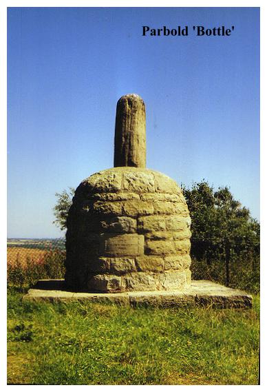
The Parbold Bottle, as follies go, is neither massive nor impressive. It is, however, decidedly curious. As its name suggests it is shaped like a bottle, but the shape is more like an eighteenth century port bottle than a modern receptacle. It is made of the local gritstone, and was erected to commemorate the 1832 Reform Bill. This viewpoint is excellent, and just off the beaten track. The coastal plain is spread out below, and there is a lovely view across the Douglas Valley. Two other follies are visible: Ashurst's Beacon on the hillside opposite, and, from the adjacent road, Blackpool Tower can be seen to the northwest. In the foreground are Parbold's two victorian churches and their sheer grandness of scale testifies to the wealth of Parbold's nineteenth century residents. Both churches were very much the gifts of influential local families.
From the Parbold Bottle we retrace our steps to the road and continue on to the summit of Parbold Beacon. Across the road, all mod cons are available at the Wiggin Tree, which is highly developed to cope with the influx of local tourists.
From the top of Parbold Hill we descend to the canal once more, skirting quarries and woodlands en route, before finally re-crossing the cut at Bridge 40. We continue onwards, crossing the River Douglas and passing over fields to a lane. Beyond an interesting farmstead with a quaintly dilapidated seventeenth century frontage and a ball finial made of wood, we start our ascent up the opposite side of the valley. Passing woodlands, we skirt what was formerly the perimeter of the Dalton Mine. From vast underground quarries, thousands of tons of roofing flags were once extracted, but now the entrances to the workings are sealed off and little trace remains of what was once an extensive industry.
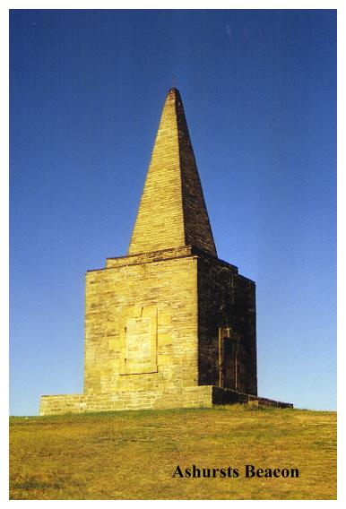
Entering a narrow lane near the entrance to the tantalisingly named Bangham Farm our route ascends at last to the summit of Ashurst's Beacon and a truly excellent prospect.
Ashurst's Beacon was erected on Ashurst Hill in 1798 by Lord Skelmersdale during the Napoleonic Wars. This was the last time that the beacons were used to warn of imminent danger, beacon sites long out of use being refurbished and manned during this period. Frequently a guard house was constructed for the soldiers manning the beacon, and this may have been the building's original purpose. Today the doors and windows are bricked up, but at least Ashurst's Beacon still retains its pyramidical top (which is more than can be said for neighbouring Billinge Beacon).
An inscription on one side of the structure informs us that it was presented to Wigan Corporation in 1962 by Mrs Florence Meadows in memory of her journalist husband Thomas, who desired that the beacon should be a public beauty spot. Those wishes have been respected with a bonus, for the area has now been developed into a country park. Ashurst's Beacon stands at 570 feet above sea level, and dominates Skelmersdale when viewed from the coastal plain. The view here is superior to that of Parbold Hill, and in addition to Blackpool Tower, the Merseyside coast and the Clwydian hills, Winter Hill and Rivington Pike may also be discerned to the north- east. A fine prospect indeed.
From Ashurst's Beacon we descend the hillside to Dalton. Dalton Hall in 1640 was a 'large castellated edifice', but now is being rebuilt as a modern house after having been demolished some years ago. Mercifully the destruction was not complete - the original seventeenth century porch and adjacent dovecote survived. The dovecote is now restored, and the old porch is being incorporated into the fabric of the new house. A plaque on the side of the dovecote informs us that "This 17th century Stone Columbarium was restored by the North West Buildings Preservation Trust. 1985". Adjacent to the dovecote is a most incredibly stagnant pond.
From Dalton we proceed (via the exquisitely shady Dungeon Lane) to Prescotts Farm and a footbridge over the River Douglas. Just before turning into Chapel House Farm, a cross surrounded by iron railings appears on the right. The inscription explains all:
Here stood Old Douglas Chapel, for four full centuries loved
and thronged by those who worshipped God from all the country round.
EXISTED 1526
REBUILT 1821 DEMOLISHED 1875
The Holy Table, Font and Pulpit are now in Douglas Parish Church.
This cross, carved from the old threshold stone was erected July 1906
" Your father's where are they?"
Returning to the canal at Bridge 39, we turn left for Parbold, and the end of our perambulation.
On a sunny summer's afternoon Parbold is a place to linger, to sit back, to relax, feed the ducks and savour the gently lapping waters of the canal. Here there are no wild moors, no seascapes, no wuthering breezes, just a gently attractive and seductively subtle charm.