11. JUBILEE TOWER QUERNMORE AND CLOUGHA PIKE
Sombre, lonely moors, and fabulously extensive views are the hallmark of this invigorating tramp in the Bowland Fells, starting and finishing at the castellated Jubilee Tower with its fine views over nearby Lancaster.
Getting There: Take Trough of Bowland road out of Lancaster, passing under the M6. Beyond Quernmore and Brow Top Farm the road takes to the open fell below Clougha Pike. The Jubilee Tower is quite unmistakeable. Park in the car park opposite.
Distance: 8 Miles
Map ref: SD 542 573
Rating: Walk*** Follies and General Interest**
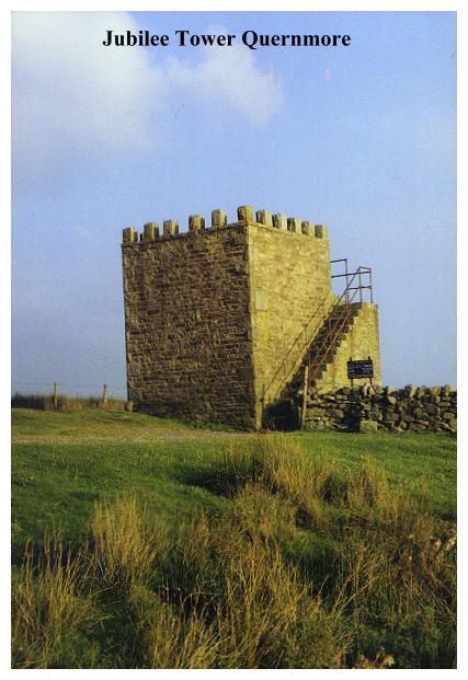
Most of the follies visited in this book have to be walked to. This particular walk, however, is exceptional in that our object is located at the start of the walk. The Jubilee Tower stands above Quernmore, beside the fell road which leads from Lancaster through the Trough of Bowland to Dunsop Bridge. There is a car-park adjacent - a popular resort for motorists who like to sit in their cars and enjoy the extensive views. Few bother to lace up their boots and take to the open fell. Alas, they don't realise what they are missing.
The Jubilee Tower is basically a castellated viewing platform served by an exterior stone staircase. It appears to be solid, there being no bricked up doors or windows at ground level to suggest the former prescence of a lower chamber. The tower was largely the work of a Mr Harrison, a native of Quernmore, and an inscribed tablet informs us that:
THIS TOWER
WAS ERECTED BY
JAMES HARRISON
OF HARE APPLETREE
IN COMMEMORATION OF THE
JUBILEE OF HER MAJESTY
QUEEN VICTORIA
ANNO DOMINI 1887
Harrison, who had made his fortune as a Liverpool shipbuilder, employed a local mason named Gifford to do most of the work on the tower (this man had also worked on Quernmore Church and Chapel). Gifford did his work well - his sturdy structure was built to withstand the cruel wind and the driving rain, hail and snow that so frequently belabour these bleak uplands during the winter months. So far, it has responded well to this challenge.
The tower has had a chequered history. It was originally in private ownership but was given to Lancashire County Council in 1973 by Mr Adam Leigh of Hare Appletree. The council at the same time began work on the present car park, and spent a considerable amount on developing the surrounding area. By 1977, however, the Lancaster Civic Society was reporting that the tower seemed to be in a poor condition, despite the council having resurfaced the viewing platform and having repointed most of the stonework. Shortly afterwards the handrail was repaired, and the tower fully restored. The wind and the rain still buffet this battered structure, but with the adjacent car park and the constant influx of summer visitors, its future (unlike many such buildings) seems assured.
The tower stands at 940 feet above sea level, and on a clear day the view is phenomenal, ranging from the Fylde coast to the Lake District. You might be forgiven for thinking this the finest view in Lancashire, but you would be wrong, for that view is yet to come - on the summit of Clougha Pike.
From the car park a path leads up onto Hare Appletree Fell. This is an ancient landscape and, not surprisingly, there are evidences of ancient people. When the car park was constructed in 1973, a seventh century burial was uncovered by a mechanical excavator. The grave contained a coffin which had been made from a hollowed-out tree trunk. Of the corpse only the hair and fingernails remained, but the cloth shroud in which it had been wrapped was excellently preserved, and is in fact one of the largest pieces of Dark Age cloth ever found in Britain. The remains are now on display in the Lancaster City Museum.
A short distance up the moor and an area of peat channel reveals further evidences of ages past. Embedded in the peat, in a state of perfect preservation, are the branches and roots of birch trees that once clothed this bleak fellside. These are not fossils - the wood has been perfectly preserved and bears the appearance of being felled only recently, but its provenance rules out any such possibility. Perhaps the log in which our unknown dark age warrior was buried in the seventh century came from the same woodlands as these tantalising half buried morsels, which still retain their original bark.
Hare Appletree Fell, along with much of the bleak landscape around Clougha Pike, is designated an Access Area - a place where the public can wander freely in certain 'controlled sectors'. The Bowland Fells are the largest expanse of privately-owned hill country in England, and perhaps more than anywhere else, typify the ongoing struggle between landowning mediaevalism on the one hand and public recreational access to open country on the other. The Clougha Access Area consists of 1,717 acres of open moorland, which sounds impressive until you realise the extent of the moorlands you are not allowed to enter. The Forest of Bowland should be a National Park. Rather it is a national disgrace. Over 5 million people live less than an hour's drive away and yet this vast tract of invigorating open space is sealed off so a handful of priveleged people can shoot a few harmless birds!
The ascent of the moor along the boundary fence to the cairn at Shooters Pike is a surprisingly long and arduous one. It is also, until the jumble of boulders is reached near the top, rather wet and muddy. According to the map we are very near the 'Castle of Cold Comfort' but there is no building in view. A ladder stile at a junction of fences announces the start of the 'access corridor' which leads around the moorland ridges to Gritfell, Wardstone and Tarnbrook.
Our route however, remains in the Access Area and proceeds round to the summit of Clougha Pike, a fine and surprisingly lengthy moorland walk. Clougha Pike is, quite literally, the high point of our walk. The summit is unmistakable with its cairn, trig point and rough stone wind shelter. Around it there is much disturbed ground, the remains of long disused quarries. Long, long ago millstones were made here, parts of the workings dating back to Roman times and beyond, when stone querns, those tiny manually operated forerunners of the modern flour mill, were exported from here in large numbers. Querns were made for domestic use, and the Romans industrialised the process, opening up large quarries, their location being evidenced in the distribution of place names - Whernside, Quernhow and, of course Quernmore.
The name Clougha Pike is supposedly of Old English origin and means 'projecting ridge', a not particularly surprising observation, for that is exactly what it is! However, there are other interpretations. It has also been suggested that the name means 'Great Rock', being derived from the old Irish 'Clogha', or 'abundance of showers' from the Celtic 'Glagwog'.
Considering its position it should come as no surprise to find that that beacons have been lit on the pike, although it does not seem to have been part of the traditional beacon system which was used in times of national emergency. The last beacon to be lit here was to celebrate VE day, and on the occasion of Queen Victoria's Jubilee a beacon was lit by the same Mr. Harrison who built the Jubilee Tower, the undertaking of this task involving a hazardous ascent to the summit in a pony and trap.
The view from Clougha Pike if it is clear quite literally takes the breath away. Here on this wind blown eminence we are standing on the roof of Lancashire. The actual height is about 1,500 feet above sea level. Pendle at 1,831 feet is higher, but even that great eminence cannot compete with the amazing prospect here! As at the Jubilee Tower the Fylde coast is in full view, Blackpool Tower being particularly noticeable in the south-west. Fleetwood and the Wyre Estuary can be plainly seen, along with the estuary of the Lune, a silvery swaithe stretching down to the sea at Sunderland Point. The massive square box to the right is the nuclear power station at Heysham. In the foreground is Lancaster, with its grim castle, and the green dome of The Ashton Memorial. Beyond lie the sands of Morecambe Bay, and a spectacular view across to Grange and the mountains of the Lake District! This prospect is also in view from the Jubilee Tower, but here at Clougha Pike we have the additional bonus of open prospects to the north and east. To the north we can scan the Lune Valley, and make out the 'Crook of Lune'. Beyond, the river winds up to Kirkby Lonsdale and eventually the Howgill Fells, where it rises. Towards Morecambe Bay, Carnforth, Warton Crag, Jenny Brown's Point and Silverdale are in view, while to the east the western edges of the Yorkshire Dales, dominated by the flat summit of Ingleborough, pop up behind the sombre Bowlands on our near horizon. There is much, much more. All of Northern Lancashire is laid out for you to see, and in this lonely spot you will, more likely than not, have it all to yourself.
To Quernmore it is downhill all the way. After descending the rocky, scree strewn slopes, we follow Rowton Brook down to the intake level, eventually joining the fell road just above Quernmore. Rowten (or Rooten) Brook has some interesting stories attached to it. One tale concerns Jenette Cragg, who lived at Rooten Brook Farm in the seventeenth century. Her son-in-law, John Kelsall, was a Quaker, who was much persecuted for his faith. He died in 1687 en route for the West Indies, whither he had been banished. His wife died shortly afterwards, leaving two orpahaned boys. Their grandmother, Jenette, when she heard of their plight, promptly mounted her pony and rode to London to find her grandchildren - a journey of around 230 miles, no mean achievement in those days. She eventually returned to Rooten Brook Farm, carrying the orphans in her panniers. She died here in 1699.
Rowton Brook in the eighteenth century was the hub of a local hat making industry. Billycock hats and sea caps were made here for export, mainly for wear by slaves and convicts. In the 18th century the area was also notorious as being a repository for contraband brandy brought in from Glasson Dock. The remoteness of the area, along with its proximity to the lonely road leading through the Trough of Bowland into Yorkshire, made it an ideal location for these illicit activities.
Our walk does not visit Quernmore, but a diversion may be made if required. Quernmore's chiefest jewel is its church, St Peter's, a Decorated fourteenth century-style structure which was built in 1860. Much of the stone was quarried on Clougha, and the east window consists of stained glass depicting the Nativity, Crucifixion and Resurrection, all of which was salvaged from the wreck of the Fairy Vision which was lost in fog near the mouth of the River RhÜne. The original window, it seems, was made in Lancaster and was intended for export to France, but the ship sank so consequently a new set of windows were made, and the order delivered. Then, amazingly, the original glass was salvaged and promptly shipped back here to Quernmore. So somewhere in France there must still be a set of matching windows.
Quernmore (pronounced 'Kworma') Has an ancient history. In 1774 a roman kiln was discovered in the area along with tiles, bricks and pottery ware dating from about AD 204. Slate was quarried in the area, and there are numerous old trackways. The Pendle Witches passed this way en route for Lancaster Castle, and many other travellers have since followed in their wake. Today it is by passed by the M6 and those Sunday drivers heading for Lancaster from the Trough of Bowland.
Leaving the road by a most curious-looking barn, our route takes to the fields once more, passing through Hare Appletree. Beyond, after a confusing route we join the farm road which leads up past Westfield House back to the Jubilee Tower and the end of our journey. If you have the time (and the energy) you could drive onwards towards Lancaster to take a look at the Ashton Memorial. More likely than not, though, you will break out the flask and sandwiches, put your feet up in the car and enjoy that magnificent view!!