15. HUMPHREY HEAD AND THE KIRKHEAD TOWER
Humphrey Head is the highest (and just about only) cliff of any size on the Lancashire coast. The Kirkhead Tower stands above it, offering excellent views over Morecambe Bay. Together they add up to a scenic and most interesting walk.
Getting there: A590 then the B5277 through Grange-Over-Sands to Allithwaite
Distance: 7 miles approx
Map refs: Allithwaite SD 386 762. Kirkhead Tower SD 393 756
Rating: Walk** Follies and General Interest *
Our walk starts at the picturesque little village of Allithwaite by the Pheasant Inn (patrons car park behind). This clustered little community, which stands on the southern slopes of Hampsfell midway between Grange and Cartmel, appears in old records as Hailinethwait, and the name is believed to be derived from the old English Halig Wella- 'the clearing by the Holy Well'. This name makes sense, as we are shortly to encounter the said 'Holy Well' on our ramble to Humphrey Head. It is also worth considering the possibility that the name is in fact Old Norse and means simply 'Halle's son's clearing'.
Allithwaite was traditionally a community of fishermen, while at Blenket Farm the only iron ore mine in the area was worked, the ore being taken to Backbarrow to be melted down. Today Allithwaite seems to be in danger of becoming a suburb of Grange. We can only hope that the village manages to retain its identity somehow.
From Allithwaite we pass over a series of flat fields to a lane before encountering our first place of interest by a bend in the road. A few hundred yards up a farm track, incongruously sited in the midst of a farmyard stand the tall, gaunt ruins of Wraysholme Tower.
Wraysholme Tower is a mediaeval pele tower, which was built, along with its near neighbours Arnside and Hazelslack Towers, to withstand the incursions into this area of the ravaging Scots, who repeatedly invaded Northern England after Bannockburn, burning and plundering the Furness area in 1322. Wraysholme Tower is not open or accessible to the public, being part of the farm, so it must therefore be inspected from a distance.
The tower reputedly dates from around 1485 (although some sources place it as far back as the thirteenth century) and it originally had a hall attached to it on its north side. It is thirty nine feet high, and the projecting turret at the south-west angle contains the tower's Garde Robe (lavatory). The tower is built of rough rubble limestone and the walls are four feet thick, reputedly cemented together with lime and bullock's blood. It was obviously designed to withstand a great deal. Comfort was sacrificed to the needs of defence, but as the building (like its sister towers) was never intended to be much more than a defensive lookout tower and an occasional hunting lodge for its owner, its comfort would not have been a major consideration anyway.
The tower was built by the Harringtons of Gleaston, who in the Middle Ages were wardens of the coast. They were a powerful and influential family with far-flung estates, Sir William Harrington of Hornby Castle being Henry V's standard bearer at Agincourt. Besides Wraysholme they also held Farleton, Arnside and Hazleslack Towers. During the Wars of the Roses, however, they fared rather badly, mainly as a result of supporting Richard III, who was a popular figure in the North. After Bosworth Field and their equally ill-starred support for the Yorkist 'pretender' Lambert Simnel (who landed on nearby Piel Island in June 1487), the estates of Sir James Harrington and his brother were seized and handed over to the Stanleys, who, as any reader of Shakespeare knows, had, during the Battle of Bosworth, switched sides at the last minute and given Henry Tudor the victory. The Stanleys (later the Earls of Derby) eventually sold off Raisholme to the Dicconson family, who held it for a time, but eventually the tower passed to humbler owners and was gradually allowed to fall into ruin. Today it functions as a farm building. Its cressets have given way to TV aerials, and its lonely sentinels to clucking chickens. An ignominious fate indeed.
Continuing on our route we cross the railway. At a junction we bear left, then follow the lane round to the rocky bulwark of Humphrey Head, which juts out onto the sands of Morecambe Bay.
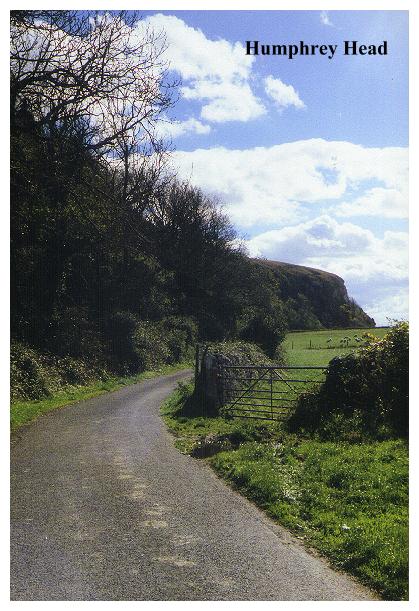
Humphrey Head is the only sea cliff of any note between North Wales and St Bees. 160 feet high, its precipices - thanks to the sands and low lying coastline all around - look higher than they actually are. From the triangulation on the summit of the headland, there is a fine prospect taking in the Pennines, the Bowlands and Lancaster; the Ashton Memorial and Blackpool Tower are also both in view. At low tide it is possible to walk right around the headland on the beach, but it is worth remembering that when the tide does come in it comes in amazingly fast, and flows right up to the base of the cliff. If in doubt, follow the top route.
Humphrey Head offers much of interest. According to legend it was the scene of a famous 'chase' (immortalised in poem and ballad) in which the last wolf was slain by one of the Harringtons of Wraysholme Tower. By all accounts, Sir Edgar Harrington offered the hand of Adela, his niece, to anyone who would rid the district of the last wolf in Cumbria. A mysterious stranger duly dispatched the creature, and upon revealing his true identity turned out to be Sir Edgar's long lost son and Adela's banished sweetheart.
At the end of the lane, near the base of the cliff stand the now pathetic remains of St Agnes Well, the stone hut which formerly covered it being long ago reduced to ruin. The Holy Well of St. Agnes has an interesting history. In the eighteenth and nineteenth centuries it was popular as a spa, and the salty waters were said to cure ague, gout, jaundice and worms. Lead miners from Alston Moor in Northumberland made an annual pilgrimage to the well, believing that it countered the effects of lead poisoning, and its waters were also poured into milk kits and carried by rail to Morecambe to be sold to holidaymakers.
From the end of the lane, hard by the beach, a steep path ascends through the woods at the base of the cliff, becoming a rock scramble as it winds right to the cliff top. Further along the base of the cliff an even more precipitous path leads up the precipice, passing through a natural 'window' in the rock. Would-be climbers would be wise though, to take heed of the following warning which is carved on a rock at the base of the cliff:
Beware how you these rocks ascend
Here WILLIAM PEDDER met his end
August 22nd 1857 Aged 10 years
By Permission
After seeking out and exploring the Fairy Chapel Cave, our route passes through the coppice wood on the eastern side of the headland, before skirting sea marshes to reach cottages and a low tunnel beneath the railway line. Here the rails are in view immediately above your head as you pass underneath - it must be a thrilling experience to be there when a train is passing directly overhead!
Beyond the railway, a choice must be made. The public footpath leads directly back to Allithwaite across some marshy fields, but a right turn gives access to a track which leads directly around the perimeter of the treatment plant and onto the flanks of Kirkhead. Although not shown as a right of way, this route is obviously used by horse riders, and therefore seems a reasonably safe bet for ramblers. (If you are squeamish, you can return to Allithwaite and visit Kirkhead from the other side, having gone round by road.)
Kirkhead is an interesting eminence. Strictly speaking it is an outlier of Hampsfell, although it is cut off from that hillside by the road and houses which are strung out to the north of it. Nestling under Kirkhead on the Kents Bank side is Abbots Hall, which was where the Abbot of Furness used to stop over when making the arduous journey across the sands from Furness Abbey to his extensive holdings in Yorkshire. Today a Methodist guest house stands on the site.
In the southern face of Kirkhead is Kirkhead Cave.(I was unable to find it on my visit) It is, by all accounts, quite well hidden in the wood scrubland and must be sought out. The cave (I am informed) stands about eighty feet above the high water mark in a low limestone scar. Its entrance is only two feet high, but inside it rises to fourteen feet and gives access to a series of caverns in the limestone. Large quantities of prehistoric bones, both human and animal, have been found in these caves along with potsherds, jewellery, a bronze spearhead and a coin dating from the time of the Emperor Domitian (AD 84). Animal bones found included those of red deer, wildcat, fox and boar. One item of interest was the metatarsal bone of a pig which had been carved into a whistle.
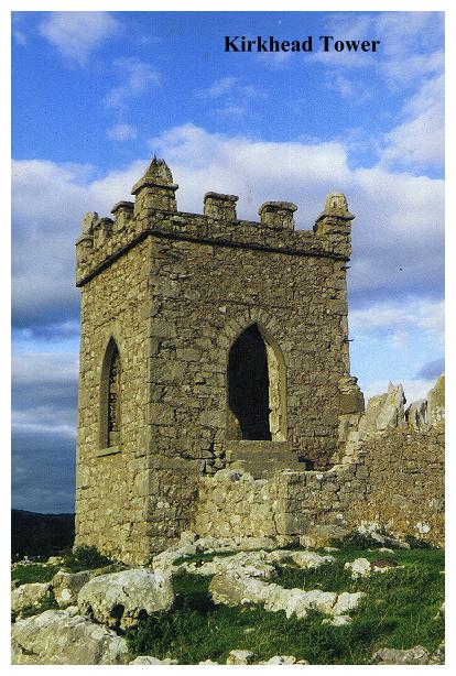
On the summit of Kirkhead lies the chief object of our journey, the Kirkhead Tower which has been in view for much of our walk. I can offer little in the way of hard information about it. It was built originally as a summer house, and its Gothic character would suggest that it dates from the nineteenth century. The views from it are, as one might expect, quite spectacular, and it is occasionally used as a venue for outdoor Sunday morning worship, its steps and arched window forming a perfect open air pulpit. According to legend, the tower was built on the site of an ancient church which, in the days before the building of Cartmel Priory, served as an oratory for the devotions of travellers. This modern usage, therefore,is perhaps quite apt. It is from this vanished chapel that the hilltop 'Kirkhead' supposedly derives its name.
From the tower, we make our way to the Kents Bank road, passing a fine lime kiln on the slope below us. A left turn from the road leads us down through an area of housing to the start of our walk at the Pheasant Inn, where, with a pint of best bitter, you can make a pleasant end to an intricate and interesting ramble.