1. THE BASLOW MONUMENTS
Gritstone edges, boulderfields, birch woodlands and fine peakland views characterise this easy walk two contrasting martial memorials high on the hills above Baslow.
Getting There: From Baslow follow A619 towards Chesterfield. Beyond the roundabout and Chatsworth Park Lodge the road ascends through crags. Turn onto the B6050 at The Robin Hood Inn then immediately left into the adjacent Birchen Edge car park . This is the start of the walk.
Distance: Two miles
Map ref: SK 281 722
Rating: Walk *** Follies and General Interest *
From the Robin Hood Inn proceed to the main (A619) road and bear right, passing a farm, and the track to the Eric Byne Campsite. Just beyond, at a step stile with a sign and 'Eastern Moors Estate' notice, a well defined footpath leads off right up the hillside passing through gorse with woods and a wall on the left. Just beyond the 'three men' the path bears left passing through a gap in the wall before descending through birch woods and a boulder field below Gardoms Edge.
Pass through two further walls, noting the fine 'lunkie hole' or 'creep' alongside the second gate. At the bottom of the wood the path passes behind buildings with a fence alongside. Beyond a stile and a small footbridge over a tiny rivulet a second stile joins the busy A621 Sheffield Road. Cross with care to a stile and gate directly opposite, where a well defined and neatly landscaped path leads down to a beautiful old stone bridge over the Bar Brook in a rocky wooded glen.
Cross the brook and ascend the steps, keeping to the left of the iron fence, and pass between a wall and the perimeter of private grounds. Beyond the next stile the path ascends steeply up a rocky birch clothed slope with the wall on the left. Just beneath the summit the path bears left and contours the slope. A short distance along and a short steep scramble gives access to the edge of the moor, where an obvious and much trodden path leads off right to the Wellington Monument.
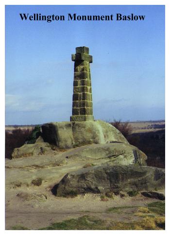
Here on Baslow Edge, we are are about a thousand feet above sea level. The Wellington Monument, a cross some ten feet high, bears the inscription: 'Wellington, Born 1769, Died 1852. Erected 1866 by E.M. Wrench, late 34th Reg'ment.' Little else seems to be known about it. One story, probably apocryphal, suggests that it was built to commemorate a visit of the Iron Duke to the area while a guest of the Duke of Rutland. Or perhaps it was merely built to provide a foil for the Nelson Monument on Birchin Edge, which we will encounter shortly.
From the Wellington Monument the walk is a fine and obvious promenade along the edge of the moor which eventually joins a fence and becomes a track which leads past an old guide stoop to join a small metalled road at a gate stile.
Guide stoops must have been a welcome sight in days gone by. The Peak District hills and and moors, like the South Pennines and Yorkshire Dales further north, were seen in the days before canals, turnpikes and railways as being major barriers to efficient communications and trade. If you were a traveller in those days, and could reach your destination without crossing the moors, you did so! There were no roads as we know them, just narrow packhorse trails over the lonely desolate wastes, sometimes paved, often not! In the frequent mists, rain and snow it was quite easy (and usually dangerous) to go astray, and guide markers were erected to show the traveller the correct route. In 1702 an Act of Parliament made the setting up of such markers at track junctions compulsory. Today guide posts and markers (discounting the wooden ones erected by Countryside Wardens!) are numerous all over the Pennine hills. They come in a bewildering array of shapes and sizes, and range from the simple to the sophisticated. The earliest were ancient standing stones and crosses, the latest, fully fledged 'guidestones' with destinations, mileages and carved pointing hands, usually dating from the eighteenth century. This particular specimen here at Baslow Edge probably falls somewhere in between. It is carved simply 'Chesterfeild Roade' in is perhaps of seventeenth century origin.
Now turn right and follow the road to its junction with the busy A621.
Recross the main road to the lane opposite then climb pass the ladder stile on the right onto open moorland. Ascend the moor towards Birchen Edge, ignoring all paths leading off to the right. The landscape around Birchen Edge is a curious mix of heather moorland, jumbled boulders and large stands of birch trees. A landscape in fact, such as would have been found all over the Pennine hills in Prehistoric times, before generations of Celtic, Anglo-Saxon and Mediaeval farmers employed spades and axes to create the bare walled pastures and treeless uplands so common today. Whether or not the birch woods here are the remains of virgin forest or are the plantations of more recent times is a matter for debate, but whatever the case, a strange almost 'prehistoric' atmosphere seems to hang over the area. This feeling is further compounded when we learn that centuries ago this area was shunned, being known in Saxon times as the 'Wormshill' i.e. - 'Dragon's Lair'! Just beneath the Edge a short path leads steeply up the slope by a boulder. Turn R. and proceed along Birchen Edge to the Ordnance Survey Pillar. Beyond, bearing slightly left the path leads without complication to Nelson's Monument.
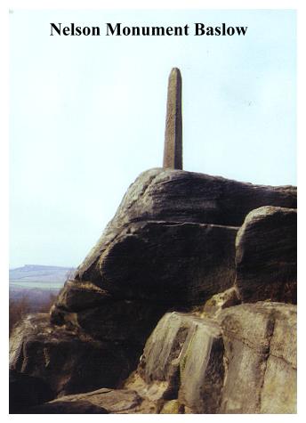
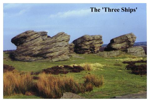
Nelson's Monument stands some twelve feet high on Birchen Edge overlooking Baslow. It is little more than a rough, pencil shaped, stone obelisk, which was erected by John Brightman, a local man in 1810, some thirty years before the Londoners got their 'Nelson's Column'! But there is more to the monument than meets the eye, for just behind the column, tacking across the open moor are three of Nelson's 'Ships of the line' - the VICTORY, the DEFIANT and the ROYAL SOVRIN! Closer examination reveals three huge boulders of shiplike proportions, and it seems that Mr. Brightman recreated Trafalgar in his imagination by carving the ships names on the 'prow' of each respective boulder!
Continue along Birchen edge, gradually descending as the Robin Hood Inn and Carpark appear below. By an iron manhole cover and two little waterworks markers, bear sharp right and descend steeply to the lower path, which runs alongside an unusually small golf course. Turn left, and descend to a stile which emerges into the B6050 alongside Robin Hood Farm. Turn right to the Robin Hood Inn and car park.