4. CRICH STAND
This pleasant ramble through woods and pastures features sweeping Peakland vistas, an ancient church, an architectural 'transplant' and a fine memorial-cum-prospect tower.... a lighthouse seventy miles from the sea!
Getting There: Follow A6 south from Matlock passing through Matlock Bath and Cromford. About two miles beyond Cromford, the road crosses the river by the Derwent Hotel. (B 5035 signed to Crich Tramway Museum). A few yards beyond the junction turn left into Whatstandwell Station Car Park.
Distance:Three miles.
Map ref:SK 333 542
Rating: Walk * Follies and General Interest ***
Admission to Crich Stand 10p. Car parking 20p. Open April-Sept 9-5.
This walk is essentially an ascent from the Derwent Valley to the hilltop above Crich with its fine views. The route back crosses tramlines of the Crich Tramway Museum, and descends through woodlands and meadows, culminating in a short stroll along the towpath of the Cromford canal.
Start Whatstandwell Station. Cross the footbridge over the railway line, ascending steps to a second footbridge over the canal; beyond, more steps lead up to the B5035. Cross to Crich Carr School then bear left up Hindersitch Lane. The road winds steeply uphill, passing a former chapel on the left. Just beyond 'Croft' take the narrow right fork up to Glen Road, which is joined opposite Derwent Terrace. Bear right following the road uphill by Myrtle House. Soon the road bears left to the Willows, the way onward becoming a narrow pathway which ascends steps to the lane above opposite a seat and watertrough. Turn right, then sharp left into a narrow ginnel between the cottages, ascending more steps before emerging into a farm road by Benthill. Pass through the stile oppposite, then up the pasture to a second stile, beyond which the pathway forks. Take the left hand path which leads through four further stiles ascending towards the spire of Crich Church. Beyond the fourth stile, just before descending to a bridge and FP up to Crich, turn left, following a grassy track to a gate which gives access to a farm road by a muddy cow wallow. Beyond, the track leads to the main road by its junction with Carr Lane opposite the Cliff Inn.
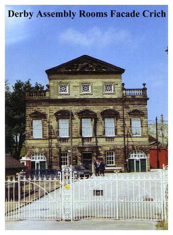
Turn left and proceed up the main road, On our left appears the entrance to the Crich Tramway Museum and the Portico of the Derby Assembly Rooms. What makes this quite out-of-place structure a folly is the fact that it is a 'transplant' from the centre of Derby! The Derby Assembly Rooms were constructed around 1755. Unfortunately, in rather more recent times the building found itself in the way of modern 'redevelopment'! To the great chagrin of the perpetrators of civic vandalisms however, it had aquired listed status, and they were therefore unable to demolish it. Not long afterwards, there was an unfortunate (and no doubt convient!) fire and the building was declared unsafe and demolished. But the facade, blackened but still intact, was taken down stone by stone, and re-erected here at Crich, at the entrance to the museum. It looks like a grand imposing building, but a closer examination reveals that there is little of any architectural substance behind it! The Museum itself began over 40 years ago when a group of tram enthusiasts, dismayed by the tram 'termination terror' of the 1950's set out to save, restore and preserve as many trams and tramway accoutrements as they could get their hands on. Unfortunately trams tend to be a bit bigger than stamps, coins and butterflies, and somewhere hugely appropriate was needed to house the ever expanding collection. The solution to their problems was found in this large abandoned quarry at Crich. Since those days the development of the museum has proceeded in leaps and bounds and the place has become a major tourist attraction (which is why you must take care when walking on nearby roads!)
At the road junction, bear right to Crich Church and village, (which is incidentally the setting for the TV series 'Peak Practice'), passing houses and a shop.
Crich Village in the eighteenth and early nineteenth century was largely given over to stocking making. This cottage industry was widely spread over the whole region, there being in the early nineteenth century some four thousand stocking frames in Derby alone. It operated in much the same manner as the domestic textile industry which flourished in the West Yorkshire Pennines prior to the industrial revolution, and the pattern of its development and subsequent demise is markedly similar. It worked this way - a Master Hosier loaned out the stocking frames to his homeworkers, and the whole family would work on production, often for fifteen hours a day, the finished stockings then being bought up by the hosier, usually for a pittance. As with the domestic woollen industry, poverty wages and technological innovations were to lead to riots, machine breaking, and the industry's eventual demise. Stockinger's cottages too, were remarkably similar to their weaver's counterparts in the Pennines, being built with long rows of windows to let in the light. By the market place here in Crich may be seen one of the few surviving Derbyshire examples of this type of dwelling, others being found in Derby, Cromford, Duffield and Bonsall.
Crich Church is a very ancient building. The nave and the North Aisle were built between 1135 and 1189, in a style distinctively early Norman.The church was enlarged c.1320 when the South Aisle was built, and not long afterwards tower, spire and chancel were added, in the Early English style. In 1356 a Chantry Chapel, dedicated to Saints Nicholas, Margaret, Katharine and Mary Magdalene was built in the North Aisle, endowed by one Sir William De Wakebridge, who not long afterwards obtained a licence to create another chantry in the South Aisle, this time dedicated to the Blessed Virgin Mary. In 1400 the roof was raised and a porch and clerestory added. Crich's bells, still in use, are mainly of 17th century date, but a new bell was added in 1900, and the 5 old bells recast in 1928, to be tuned to the new bell. Two further bells have been added by relatives of victims of the First World War. The font, (not surprisingly) is early Norman, and exhibits fine cable pattern carving.
As folly hunting and the hunting out of eccentric and unusual memento mori go hand in hand, the visitor to Crich Church will be well rewarded by some of the interesting memorials to be found here. In the North Aisle is a Galilee Tomb, with a recumbent figure believed to be of Sir William De Wakebridge. He was a man who knew tragedy. In 1348 Sir William lost his father, wife, three brothers,two sisters and a sister-in-law to the dreaded Black Death. This left him as head of the family (a bit ironic considering there can't have been much of the family left!). Nearby a brass plate in the wall commemorates the infant son of Thomas Shelmerdine, a Presbyterian Minister of the Commonwealth period."Noe sooner bloomed but blasted. Yet to revive with thine at the refreshing. Ephraim Shelmerdine. March 1st 1637". Also to be found in the church is an alabaster table tomb from 1632, much vandalised in the 18th century, to the Clay family. The inscriptions are now lost, but happily their substance is preserved. 'Claye' is one of those unfortunate surnames, which in days gone by, must have made the composers of epitaphs smile and rub their hands with glee, such is the immense scope offered for punning on gravestones. As in churches elsewhere, the following extracts show that the authors of the inscriptions at Crich could not, alas, resist the temptation!
Here lyeth John Claye, gentleman, and Mary whom he first did wive;
With here he lived eight years space, in which God gave them children five,
Daughter to William Calton, Esquir., who was unto that Kinge of fame
Henri the eight chief cock matcher and servant of his hawkes by name....
...And now this Claye is closed in claye, the fairest flesh doth fade like grass;
Hee had one sister who unto Stuffyn, of Shirebrook married was.
.....For death doth give an end to all, and now this Claye shall rest herein:
All Claye to claye shall come at last, by Death the due reward of synne.
Thowe deathe, his deathe, thy deathe is hee whose soul doth live with Crist for aye;
The stinge of death can no-one flee; the greatest monarchs are but claye."
From the church gates turn left down a small lane by Penfold, then left again through a small kissing gate, following a footpath which passes behind the church through the northeastern part of the graveyard. Leaving the graveyard by a second kissing gate the footpath proceeds across fields passing through two stiles before entering Plaistow Green Road. Bear right, then (on the bend) left, following the lane up to Crich Stand.
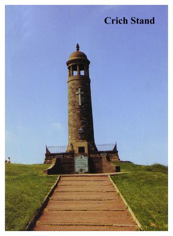
Crich Stand, towering above the Amber and Derwent Valleys at over 900 feet above sea level, is not strictly a folly, it is a war memorial. But it is indisputably a prospect tower, with public access to its viewing platform, and as such, deserves a place in this book. Not surprisingly perhaps, the Stand is the third tower to occupy this site, being erected in 1923 as a memorial to those soldiers of the Derbyshire and Nottinghamshire Regiment (The Sherwood Foresters) who gave their lives in two world wars. The first tower to be erected on this spot was constructed by Francis Hurt of Alderwasley Hall in 1788, which was, along with the second tower of 1851, badly damaged by lightning. The present Stand is essentially a 'lighthouse' in form, which makes it faintly reminiscent of 'The Hoad' up at Ulverston, but no lighthouse was ever so far from the sea as this one! Crowning the Stand, (which teeters bravely above sheer quarry faces falling away into the grounds of the tramway museum) is a revolving light, which it is said can be seen over eight counties.
Beyond Crich Stand bear right at the Trig. Point, following a well defined path downhill, passing a small cairn with quarry workings on the left and fence on the right. At a junction of paths bear left, following a lane which soon leads downhill to cross the museum tramway near its terminus. Beyond, the path descends left through hedgerows to join the farm road by Cliff Castle Farm, where there is a caravan club site. On reaching the farm road bear left, and follow it downhill, keeping the stream on the right, passing Wakebridge Cottage and Staddlestone on the left.
On joining the tarmac road turn right, then left to a signed footpath and stile, beyond which a well defined grassy path leads downhill through pastures with the stream now in a wooded dell on the left. Beyond a wooded knoll the path bears right before passing through a succession of stiles, entering woodland near a pipe on concrete piers. Descend through the wood, crossing the stream and ignoring footpaths leading off to imposing disused quarries on the left. Cross a tarmac lane, and continue down through woods to a footbridge over the Cromford Canal.
The Cromford Canal is no longer navigable. It was originally connected with Nottingham, but a tunnel collapse effectively blocked it off. It owes its origins to that great pioneer of waterways, James Brindley, whose advances made it possible for Richard Arkwright to build his cotton mill at Cromford in 1770, utilising that famous 'water frame' of his own invention. (See Walk 9). The canal was actually built some 21 years after Brindley's death, by Jessop and Outram, later to be pioneers of the railways. Opened in 1793, it carried stone and lead ore from the Derbyshire mines. Stone for the building of St. Georges Hall, Liverpool, travelled by this route, along with the Hall's four enormous stone lions, each 13 ft long and sculptured in Darley Dale ashlar. The canal was also used for passenger services too, decorated 'trip boats' carrying sightseers up to Matlock Bath. In 1849 however, the railway arrived and the canal fell into decline. Walking alongside the peaceful and weed choked canal back to Whatstandwell, it is hard to imagine the bustling artery of commerce it must once have been. Today all the industry has gone elsewhere.
At the bridge, turn left onto the towpath and follow the canal to the Whatstandwell Road. Turn right and descend to the Derwent Hotel, then follow the main road back to the Station Carpark.