9. RIBER CASTLE
A straightforward and interesting walk to a hilltop folly offering some of the finest views in Derbyshire. Also a visit to a cradle of the Industrial Revolution.
Getting There: Follow A6 Trunk Road From Buxton through Bakewell, Matlock & Matlock Bath. On reaching the road junction at Cromford, just south of Matlock Bath, turn left towards Cromford Bridge passing Cromford Mill on the left and Cromford Wharf picnic area on the right. Cross the Derwent at Cromford Bridge and continue onwards along Lea Road to Cromford Station, where a signed lane on the left leads up to the station yard. This is the start of the walk.
Distance: 6 miles.
Map ref: Riber Castle Sheet 129 SK 307 591 Cromford Station SK 303 574
Rating: *** Walk Follies and General Interest ***
Cromford is an interesting little place, often ignored by those in search of the rather more advertised attractions of Matlock & Matlock Bath, but it is well worthy of exploration, for like Worsley in distant Manchester it is one of the birthplaces of the Industrial Revolution. This distinction is due to the aspirations of one man, Richard Arkwright. Arkright, probably the greatest entrepreneur of the 18th century, was born at Preston in 1732. He began his career as a barber and wigmaker's apprentice, and finished up with a fortune and a knighthood. Finding little support for his ideas in Lancashire, he moved to Nottingham, where the stocking industry supported men with new ideas. Assisted by able financial backers, he came to Cromford, where the River Derwent, thrusting strongly through the deep Matlock Gorge is prevented from freezing in winter by warm water from thermal spa springs. This ensured him a supply of water for his frames all year round. Arkwight harnessed waters from the Derwent,Cromford Moor Sough and Bonsall Brook to power his machinery, the spent waters feeding the canal, which was used to carry away his finished goods. Within eight years three hundred men were in employment in England's first water powered cotton mill, making thread for stockings and Arkwright's fortunes were assured. In 1777 he built a second mill at Cromford, and followed it up with four further mills elsewhere, the largest being a spinning mill in Manchester, built in 1780, which employed 600 workers. Arkwright left his mark elsewhere in Cromford too. He built the school, the Greyhound Hotel, nearby Willersley Castle and the church, where he lies buried.
We pass Arkwright's Mill en route to the start of our walk at Cromford Station. Today it has car parking, a small museum and a cafe. Further down on the right, there is a pleasant picnic area by the canal wharf, with a charming bookshop/teashop in the canal warehouse, along with toilets and a large car park. (Pay & display 20p per hour, £1.50 per day). If you don't mind paying, this would be a good start and finish for the walk - but Cromford Station is nearer to the start of the walk, and it's free!
Cromford Station is almost a folly in its own right! Quite out of character with the area, it was built,(along with its matching stationmaster's villa) in 1860 in a fussy style that is distinctively French! The design is believed to be by G.H.Stokes, son-in-law of Sir Joseph Paxton. Today the railway is still in use, but it only goes to Matlock, the continuation that ran to Buxton and Manchester falling under the Beeching axe in 1968.
So to the walk! From Cromford Station descend the lane and small flight of steps to the main road. Turn left under the railway bridge (no. 23). Just beyond, a stile (waymarked 'Derwent Valley Walk') appears on the left. From here the path leads steeply up the hillside, skirting the edge of the wood by Wood End. The footpath crosses a path, and then continues straight ahead, climbing steeply (and indistinctly ) past an outcrop of shaly ground, beyond which the path is easily seen again. Keep the wood on your right and the hayfield on your left and you won't go far wrong! Soon the path reaches a farm road and a wall. Cross it and pass through the wall stile ascending diagonally to the right, following the wallside up the hill. There are now fine views back to Cromford and the Derwent Valley below. Soon the path mounts a small knoll, and continues upwards, passing beneath ascending powerlines, with woods to right and left. The path enters the lefthand wood through a stile and continues upwards, a narrow corridor twixt a wooded bank (left) and the wall (right). Next the wall veers away from the path and we ascend beneath mature beeches to a farm road. On reaching the track, bear left. This farm track proceeds without complication to Hearthstone Farm, passing the rocky boulder field of Bilberry Knoll en route (on the left). To the right Crich Stand is in view, and soon, beyond the knoll we see Riber Castle.
The track joins another coming in from the right by a cattle grid, and we proceed without complication to Hearthstone Farm, beyond which a well waymarked footpath leads off to the right, down a narrow corridor between newly planted trees, passing over pastures and three stiles to enter Carr Lane near its junction with Riber Road. Turn right, following the lane past lovely Riber Hall to the next junction, where we turn left uphill to the entrance to Riber Castle, passing a cottage with 'gothick' windows and a castellated square 'lodge' en route.
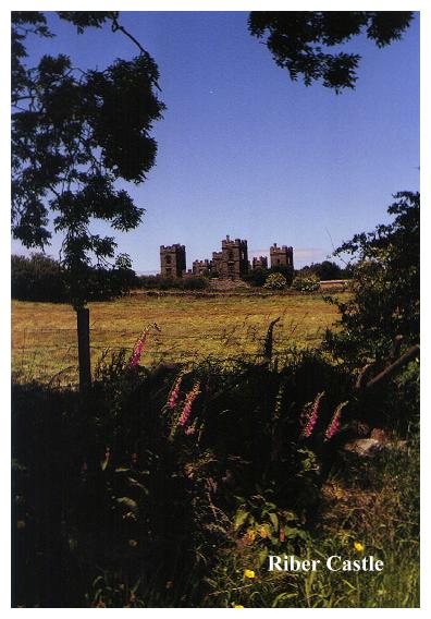
Riber Castle dominates the horizon hereabouts. It is reminiscent of similar 'Baronial' mansions to be found at Castle Carr and Dobroyd Castle in the Calderdale South Pennines. This crenellated, ruined building is not a misplaced 'burg' from the Rhineland. It was built in 1862 by one John Smedley, a local textile manufacturer, as his baronial residence! Unfortunately he died just after it was finished. Smedley was a remarkable local philanthropist. He provided his workers with beds and waterproofs, dispensed Fearns Family Pills to sick operatives and operated a sickness benefit scheme. Smedley was both a dedicated Methodist and a hydrotherapist. He built numerous local chapels and was also responsible for enlarging the Hydrotherapy Centre at Matlock Bank, which had opened in 1852. Riber Castle cost £60,000 to build. Smedley had originally intended a tower. It would have been 225 feet high with an observatory on top, but the telescopes he intended to order wouldn't fit, so Smedley abandoned the idea and built his castle instead. The Castle was eventually used as a school and a wartime food store, before eventually falling into disrepair and ultimately ruin. In 1962 the castle grounds were made into a zoo and nature reserve for British and European animals. Admission at time of writing (1996) is four pounds.
From Riber Castle follow the footpath (signed 'Matlock') which leads through a narrow corridor twixt fence and trees to the right of the main gate, to emerge onto the open hillside where there are excellent views over Matlock. Here is a good spot to call a refreshment halt and enjoy the fine view.
At Matlock we are in gorge country. In some parts one might be forgiven for thinking that we were somewhere in the French Dordogne! Matlock and its neighbour, Matlock Bath in the gorge downstream, stand at the heart of some of the most varied and interesting countryside in Britain.
The area has been long frequented. Some of the leadmines hereabouts were mined in roman times, and by the mid 19th century almost ten per cent of Britain's output of lead was coming from deep under the limestone knolls of Derbyshire. Matlock has also been much visited by people in search of its curative waters, particularly during the eighteenth century, when it developed as a spa. Matlock Bath has thermal springs which have remained at a constant temperature of twenty degrees Centigrade (68 deg. Fahrenheit) for many centuries.
Now continue downwards, following a paved path with bannister rails, crossing a track with a small cottage on the right. Continue on downwards to a junction of paths just above Matlock, and bear left, following a path which contours the hillside, passing a water booster station to the charming little hamlet of Ward's End. On entering the lane turn left, and follow the road steeply up the hillside via a series of bends, keeping a sharp lookout for traffic (this being the main road access to Riber Castle). On reaching the topmost bend, take the waymarked footpath which leads straight on, with a wallside on the left, and to the right the Derwent Valley with fine views of Matlock Bath below and the Heights of Abraham opposite.
The Heights of Abraham, were so named after an officer of General Wolfes' army remarked that the rocky hillside reminded him of the battle for Quebec! On the edge of the Heights, at the top of the chairlift stands The Victoria Tower, a prospect tower erected in 1844 by John Petchell in order to provide temporary labour for unemployed craftsmen during the 'hungry forties'. The round, roughstone tower is echoed by two similar turrets on houses far below. Various interesting walks are available on the Heights, which are easily accessible on the Chairlift, from which Rutland and Masson caverns may be visited, along with the Tower itself. All of this, however, costs! The Heights are a well known and frequented tourist attraction, and there is a hefty admission charge. (In 1970 it was one shilling!)
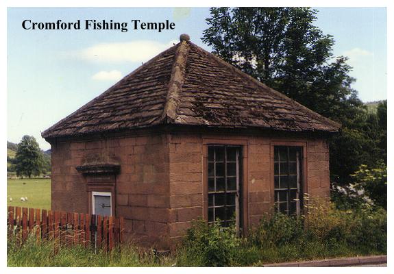
Beyond a stile, the path bears diagonally right down the hillside below Littlemoor, passing through bracken and gorse (neck high in summer!). A second stile enters a pasture, beyond which a 'squeeze' stile gives access to more bracken, scrub, and then a third stile leads into mature woodland. Beyond the wood and yet another stile the path descends unerringly to the Matlock Green/Cromford road. Turn left down the lane, and then, walking on the right to face oncoming traffic, descend the lane for approximately half a mile to its junction with Lea Road and Mill Road, adjacent to Cromford Bridge. Here a left turn leads back down Lea Road to Cromford Station and the start of our walk, but before doing so Cromford Bridge merits a brief diversion, for here, on the far side of the sleepy, tranquil Derwent, three curiosities stand side by side!
The first thing we notice is a weathered, somewhat cryptic inscription on the parapet of Cromford's fine mediaeval bridge:
'THE+LEAP:OF: M.
B:H MARE+ UNE.1697
It commemorates a most amazing happening, when a horse being ridden by one Benjamin Haywood leapt over the paraapet, crashing horse and rider into the river below! Amazingly the horse landed on its feet and Haywood was not unseated! The ruin adjacent to the bridge just beyond the carved stone, is all that remains of a 15th century chantry chapel, where travellers halted to give thanks for a safe journey. A similar chapel once adorned the bridge at Swarkestone (SEE WALK 14), and complete examples may be found at Derby, Wakefield, Rotherham and St. Ives (Hunts.). The curious building with the pointed roof standing adjacent to the ruins of the bridge chapel is not a tollhouse but a Fishing Temple, constructed along the same lines as the better known one in Beresford Dale. Like Cotton and Walton's temple it carries the inscription Piscatoribus Sacrum over the door.
Retrace your steps over the bridge and follow Lea Road back to Cromford Station and the start of the walk.