11. ROWTER ROCKS AND THE REFORM TOWER
An easy and interesting walk offering rock scrambling, abundant prehistoric remains and fine sweeping views over the Derwent Valley.
Getting There: From Matlock follow the A6 towards Bakewell. Approx. 2 miles Northwest of Matlock turn left onto the B5057 passing through Darley Bridge, Wensley and Winster. Beyond Winster follow the B5056 northwards for about two miles before turning right into the lane to Birchover. There is no car park at Birchover and you must park (sensibly) on the village street. If you are really stuck there is a parking area near Ann Twyfords Quarry (see map).
Distance: Three miles
Map ref: SK 237 622
Rating: Walk *** Follies and General Interest ***
Bus information: From Birchover there are buses to Bakewell, Winster and Matlock. Services 170 and 172. Generally speaking there is one every hour. There are no bus services on Sundays.
NOTE: With the exception of the farmyard at Barn Farm (which can easily be avoided if necessary) this walk makes for a good winter excursion, being remarkably lacking in wet, muddy ground.
Birchover has its own special charm. A linear village, straggling a country lane, it lies beneath birchwoods and boulders. In the Domesday Book it was referred to as 'Barcovere' - 'at the birch-covered steep slope'- I rest my case! Birchover is a place of sturdy cottages built in warm pinkish stone with soot blackened chimney stacks and a smell of burning coal in the air. Yet despite its obvious charm it falls just short of being picturesque, a fact which no doubt saves its inhabitants from the plastic tourist industry which continually disrupts the life of so many Peakland villages. Here there are just two pubs, two chapels, a church, a bus shelter, clean public toilets and a village shop. Older attractions include the village pinfold, where stray animals were incarcerated and the village well, which stands in a grassy triangle at the mouth of a road junction, square and sealed with an iron lid. Nearby stands the war memorial which lists the names of the five Birchover Men lost their lives in two world wars (four in the Great War and one in World War Two).
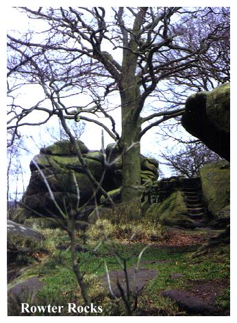
Our walk starts opposite the Red Lion Inn, and our first objective is the Rowter Rocks. Proceed downhill to The Druid Inn at the bottom of the village street. Where the road bends right, continue onwards down a small lane, passing the front of the Druid Inn, and a odd square cottage with a pillared porch. Before reaching the church (St Michaels) an obvious footpath leads off to the right, ascending steps behind the Druid Inn. These lead directly to the Rowter Rocks.
At first sight Rowter ('Rough Tor') Rocks are little more than a jumble of gritstone boulders on a wooded knoll, yet closer inspection reveals that nature has been 'improved upon', and what we really have is a distinctly Derbyshire kind of folly. After ascending mossy, rock cut steps a long low fissure cave pierces the rock, and further on we observe that dark echoing chambers have been hollowed out. Worn steps through a narrow cleft lead to a higher level where we find a pair of rock-cut seats, the best one a three seater armchair carved out of the gritstone. The highest boulder on the knoll is topped with a small stone column.
This eccentric modification of what was originally little more than a typical Derbyshire 'Tor' was the work of the Reverend Thomas Eyre, who lived at nearby Rowter Hall and who died in 1717. The big chamber he carved out was his 'study' and the seats and steps were provided so his friends could easily ascend the outcrop and enjoy the views. The column on the summit of the tor was crowned with a weathercock which has long since disappeared. Rowter Rocks also once possessed a 'rocking stone'. This perched boulder was a block about twelve feet high and some thirty feet in circumference, weighing something in the region of fifty tons. In the 18th century it was described as being 'so equally poised upon one end that a child might easily give it a vibratory motion'. Alas, the stone will vibrate no more as on Whit Sunday 1799 it was rocked off its perch by a gang of young bucks intent on vandalism! Nothing it seems is new!
Formerly it was believed that the rocks, like the neighbouring outcrop of 'Mock Beggars Hall' (or 'Robin Hood's Stride'), just across the valley, were sacred to the Druids (which accounts for the name of the nearby pub). This of course, is the usual victorian romantic fancy, but it is quite possible that these boulders were sacred to the prehistoric inhabitants of the area. It is well known that 'rocking stones' are traditional sites of pagan veneration, and are often the subject of local folklore.
If you have kids, keep them on a tight leash when exploring the Rowter Rocks. The boulders can be slippy and the drops sudden. Some years ago a child was killed while rock scrambling here. With care, the kids will find the place a delight, but do try to keep druidic sacrifices to a minimum. Blood on the rocks is unsightly and damages the eco-system. The same goes for litter. Leave nothing but your echo.
Directly underneath the rocks, Birchover Church (St. Michaels - an appropriate name for such a location) contains a remarkably eccentric pulpit dating from the 1939-45 war. Unable to purchase the wood he wanted due to rationing, the vicar had to make do with what he could get his hands on and consequently the finished article contains twenty two different kinds of wood! The base was made from the stump of a pear tree in the vicar's orchard, and parts of the decoration came from an old picture frame!
After exploring Rowter Rocks return to the Druid Inn. Across the road, on the bend, a path leads up into woodland, passing behind the rooftops of Birchover. A gradual ascent through rocky birch woodland skirts the overgrown ruins of Barton Hill Quarries before emerging into a lane opposite Ann Twyfords Quarry, where a carved millstone reads 'Ann Twyford Dimensional Stone Ltd'.
Ann Twyfords is a working quarry, where occasional echoing rumbles tell of blasting in progress. It is too easy to dismiss the quarry as yet another blight upon a beautiful hillside, but it is worth remembering that quarrying is not only a source of local employment, but is also a traditional industry in this area, as the large number of abandoned quarry delphs nearby testify. And Ann Twyfords is no commonplace undertaking. It is one of the few quarries in the country still producing those traditional millstones so symbolic of the Derbyshire uplands - the logo of the National Park. Quarries in this area were also well known for the production of 'pulp stones' for use in the papermaking industry. Ann Twyfords also produces grindstones for knife sharpening and glass bevelling and large quantities of fine dressed masonry for constructional use.
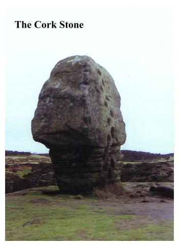
Turn left and follow the lane towards Stanton in Peak. Ignore the first two footpaths leading off to the right, but at the third turn right, where, beyond a gate, with the fence on your right, a well designed footpath leads without complication to the Cork Stone. There is not much chance of losing your way here for this wind sculpted boulder is unmistakeable. It looks exactly like a bottle stopper. On one side of it iron rungs and worn footholds offer a precarious ascent for the young and intrepid. But really there is not much point, for the stone is only about fifteen feet high, and you can see little more from the top than you can see from ground level.
From the Cork Stone continue onwards to a crossing of footpaths. Here turn left,
passing the remains of a burial cairn on the right. The well defined footpath leads north eastwards over Stanton Moor towards trees. As you enter this sparse woodland the Nine Ladies stone circle appears on your left.
The Nine Ladies Stone Circle was formerly enclosed by a circular wall which has since been removed, and it now appears in a more natural setting. Unfortunately this setting is marred by litter and the remains of camp fires, no doubt left by 'new age' worshippers who seem to delight in desecrating that which they purport to hold sacred. The atmosphere of the place is further eroded by building refuse tipped in a nearby quarry.
Yet for those interested in prehistory Stanton Moor offers much more than this mini stonehenge, fascinating though it may be. It is in fact one of the finest bronze age sites in Britain. The whole moor is studded with some 70 prehistoric burial cairns, several circles and ring cairns and the King Stone, all of them dating from c.2000 - 1400 B.C.. Also, unlike many such sites, one does not need expertise in archaeology, (or for that matter aerial photography) to be able to pinpoint their location. Stanton Moor was used intensively in the bronze age as both a cemetery and a sacred site, though not, it would seem as a settlement, no remains of dwellings ever having been discovered. The cairns were extensively excavated in the 1920's and 30's by the Heathcote Family of Birchover, who discovered small beakers containing cremated remains and beads of faience, bone and fossil. Flints and chert flakes were also discovered, the tools of these mysterious vanished people. The best urns and artefacts discovered belonged, it seems, to women, who were probably outnumbered by the men, the implication being that the community was in fact matriarchal, the women ruling the roost and taking numerous husbands! Mr. J. Percy Heathcote established a private museum in Birchover to house the finds.
From Nine Ladies Circle we follow the obvious path through the woods to the Reform Tower, which is reached by climbing a stile in the fence.
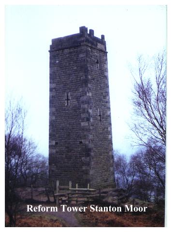
The Reform Tower, as its name suggests, was built to commemorate the Reform Bill and an inscription over the door (now vanished) once read 'Earl Grey 1832'. Its builder was Lt. Colonel Thornhill of Stanton Hall, whose family were also responsible for numerous carvings and initials carved on boulders in the area. The Thornhills it seems, liked to leave 'their mark'. Today it would be called 'Genteel vandalism'.
Today's vandals it seems have continued from where the Thornhills left off. Like many of our 19th century prospect towers the reform Tower is in a sad state of decay. Its grey walls contain arrow slits, and it was obviously crenellated, though only one side now retains its original parapet. Predictably enough its entrance door is walled up, and there is no access to the tower. The story is always the same, the tower is vandalised so the authorities seal it off for 'safety' although the what they really want to 'save' is money. Then it is left to quietly fall down. Mercifully, with our heightened awareness of the architectural significance of these 'rogue' buildings, the trend is reversing, but there is a long way to go yet. Hopefully one day walkers and picnickers on this pleasant hillside will once again be able to ascend the tower and enjoy the fine views over the Derwent Valley to Sydnope Stand and Riber Castle. We live in hopes.
From the tower, descend steps to the main footpath (NT sign Stanton Moor Edge) and turn right. The footpath leads along the edge, rocky,wooded slope on left and fence on right. After a hundred yards or so, the footpath and fence bear right near a large boulder with worn rock-cut footholds bearing the inscriptions 'CHS' and 'EIN 1831'. Follow the footpath along the fence noting a rock on the right, bearing the inscription 'DR 1815'. On the left are small abandoned quarry workings, cut into the hillside. At a junction of paths, just before the path you have been following descends, turn right through the stile and follow a path which leads diagonally across the moor towards a derelict quarry building (Birchover Quarry). Ignore a path coming in from the right and continue onwards, descending to join the metalled lane, which may be followed directly back to Birchover if required. Alternatively, proceed along the lane a few yards before bearing right onto the signed footpath leading towards Barn Farm. Pass behind the farm buildings, bearing right to a signpost and junction of paths (muddy!). Turn right through the stile and follow the well defined track past the camp site to rejoin the lane opposite Ann Twyfords Quarry. Turn left for Birchover and the start of the walk.