15. WHITE NANCY & TOWER HILL
A long and peaceful ramble amid green and rolling hills culminating in a fine ridge walk with sweeping views over Macclesfield and the Cheshire Plain.
Getting There: Follow the B5470 from Whaley Bridge, passing through Kettleshulme. (This road has been downgraded and may be depicted on older maps as the A 5002). Just beyond the Highwayman Inn, turn left down a narrow lane, and follow it about a mile to a small junction. Turn right and follow the lane down to the carpark, toilets and picnic area at the head of Lamaload Reservoir.
Distance: Five miles approx.
Map ref: Landranger Sheet 118 SJ 976 754. Lamaload CP.
Rating: Walk *** Follies and General Interest **
From the toilet block at Lamaload Reservoir take the obvious footpath which leads downhill, winding round a narrow arm of the lake. After following a track up through woods for a short distance the path bears right to a gateway. Pass through the gateway and descend the steep grassy hillside to the water treatment works below, passing a solitary tree and three waymarked posts. At the gate to the treatment plant turn right, crossing a small rivulet between fences (waymarked 'Salter's Way') before following a well defined path which winds steeply up the hillside to join the farmtrack at Yearnslow Farm. (Halfway up, Jodrell Bank is visible through a nick in the hills). Follow the track onwards, skirting a wall capped tumulus on the left. The track bears left, and after a short ascent by Cutlers Farm, White Nancy comes into view on the edge of a steep escarpment. Now the farm road descends without complication to join the B5470 just above Rainow.
Rainow is one of those deceptive place names. It has nothing to do with the climate. In 1288 it is referred to as 'Ravenhoh' which means 'Raven Hill' and the present name is, of course, a corruption of that.
Cross the road (with care!) and bear right to some cottages where a signed footpath on the left leads through a succession of stiles to the brook in Ginclough. Cross the stream (it looks like there was a plank bridge, but this has gone) and pass through two stiles, skirting a small reservoir on the left to join a track by a prefabricated farm building. Bear left to a stile which gives access to a metalled lane opposite Lower House.
Turn left, then at a small D shaped grassy island with white bollards, bear right, following a sunken stony lane which first ascends then descends, as it winds northwards towards Oakenbank. On reaching a stone gatepost on the left with a large letter 'I' painted on it, pass through the stile and bear diagonally to the right across the pasture to Ingersley Hall Farm, where the Gritstone Way comes in from the right. Pass through a stile, (noting the waymark), and descend the hillside to a second stile, beyond which steps descend through trees to a stone bridge over a stream marked with a painted letter 'R'.
Cross the bridge to the lane, (which leads to a mill complex) and bear left. A short distance on, a track signed 'North End Farm- Private Road' appears on the right. Turn right and follow this up the hillside. Beyond the farm, tree shelters and a cattle grid, turn left, following a steep grassy path up the face of the scarp to White Nancy on the northern end of Kerridge, where there is a fine view over Bollington.
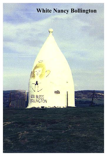
White Nancy is a curious structure. A white, inverted spinning top, surmounted by a ball finial, it is a landmark visible for miles around. It was built in 1817 by one Colonel Gaskell of North End Farm to commemorate Wellington's victory over Napoleon at Waterloo. Below White Nancy, Bollington has a castellated chimney, built in 1840 for one William Clayton. beyond, in the distance, lies Manchester airport, from which (on a clear day) aircraft may be seen landing and taking off.
From White Nancy a fine ridge walk leads along the Saddle of Kerridge with excellent views on both sides. At the fourth stile and a junction of paths, just before the onwards path ascends to the trig. point, bear left, diagonally descending the grassy eastern slope, passing through stiles. By a wall, where there is a stone slab with a round hole in it, descend left, and follow an obvious (and muddy) track down to the ruins of Cow Lane Mill. Cross the stream and follow the track up to the main road just below the Rising Sun Inn. Turn left to the roughstone Folly Tower at Tower Hill Hall.
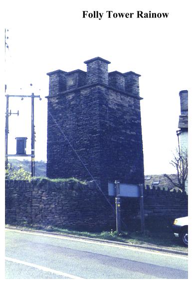
This castellated tower, while having little to commend it architecturally, is of interest in that there seems to be a complete lack of knowledge as to its origin and history. Any pertinant information would be most welcome!
Almost opposite the tower turn right onto the signed Lamaload waterworks road, passing cottages on the right. (Ravenowe).A short distance along the track the Gritstone Trail leads off right. Ignore this and continue onwards,following the waterworks road, passing a plantation of conifers and some farmhouses. The road leads up the southern side of the lovely Dean Valley to Snipe House, before descending steeply to Lamaload Water Treatment Plant. At the main gate, turn right and follow a paved footpath (Salters Way) around the perimeter of the works, crossing a small stream coming down from the reservoir. At the next signpost turn right and follow the outward route back to the carpark at Lamaload Reservoir.
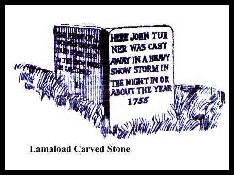
This walk has a postscript. Before you leave, take a stroll up the lane that brought you here. Tucked away beneath the drystone wall on the right as you ascend the lane, is a small, inscribed stone with a curious inscription:-
"Here John Turner was cast away in a heavy snowstorm in the night in or about the year 1755." The reverse of the stone reads:-" The print of a woman's shoe was found by his side in the snow were [sic] he lay dead".
Therein lies a mystery !