St Bees Head to Robin Hoods Bay.
As walked by Jim Jarratt June 1973.
This is the story of a Coast-to-Coast walk. The walk that culminated in the Pathfinder. I walked Wainwrights now famous long distance footpath from St. Bees Head to Robin Hoods Bay in eleven days, but a strong walker would do it in less. What follows here is not so much a guide to the walk, but rather the story of one mans impressions and experiences in walking it. The Coast-to-Coast is a tough walk of around 190 miles, exhilarating sometimes, exasperating at others! For variety it puts the Pennine Way to shame. The country is perfect - traversing high ground for most of the way it crosses the Lake District, The Westmorland Limestone Plateau, The High Pennines, the length of Swaledale, the Vale of Mowbray, the Cleveland Hills and the North Yorkshire Moors. On my crossing I was lucky- the weather was excellent. The hills of Northern England are not always so.
First Day. 3.6.73. St Bees to Gillerthwaite.
' A fine start to such an adventure' I thought As I ate my breakfast in the basement dining room at Tomlin House, St. Bees, watching the raindrops trickle down the window panes, beyond which lay a thick murk over the Irish Sea. The previous day I had disembarked from a coach in Keswick in brilliant sunshine, caught a bus to the rather less hiker friendly town of Whitehaven, and then found myself having to wait two hours to catch a bus to St. Bees., by which time it was raining. It was now morning, and the rain hadn't stopped. My proposed journey had aroused much interest in the boarding house. They didn't see much in the way of hikers hereabouts, the boots-and-rucksack set tended to stay in the Lake District in this county. St Bees was a place for caravans, buckets and spades.
Making my farewells I set off on my adventure. I didn't get far - the rain was torrential and within a few hundred yards I was sheltering under a kiddies slide in the nearby playground, awaiting a break in the weather.
I didn't have to wait too long. The rain eased, and as I crossed the footbridge over the little beck and climbed the steep path alongside the fence onto St. Bees Head, the sun came out and sparkled on the damp grass, as seabirds wheeled around this lofty bulwark of brown sandstone that justs out into the Irish Sea. As I climbed, the view opened up and I could see the Isle of Man out at sea, the serrated skyline of the Western Fells of Lakeland, and to the north west, the Galloway Hills across the Solway Firth - exhilarating views!
I descended to the Beach at Fleswick Bay, a steep and narrow cleft between the cliffs of the North and South Head. Anglers were sitting on the pebbles alongside their beach rods. Idly beachcombing, I found a small pebble with a hole in it and a piece of fluorescent orange fishing net twine. I threaded the pebble with the line and tied it round my neck. I was going to take this bit of the Irish Sea to Robin Hoods Bay! I wet my boots in the sea for the last time. All being well my boots would next touch seawater in the North Sea - yes this WAS going to be an adventure!
After a rock scramble at Fleswick Bay I walked along the North Head to St. Bees Lighthouse, at which point I finally turned inland - now the walk was underway with a vengeance! At Sandwith I enjoyed a pint in pleasant company before continuing once more on my way. Before me the mountains and the industry of Whitehaven on my left. Barbed wire, hedghogs and a filthy marsh to contend with at Stanley Pond, a reedy pool in a dismal hollow below a railway track. Passing through Moor Row and Cleator I decided to follow a farm road through to Ennerdale Bridge, missing the green fell of Dent from the itinerary - a sound decision as it turned out. The afternoon was hot and the walk to Ennerdale Bridge a sweating blistering slog. I arrived there about 5pm, consuming a bottle of pop with relish. This should have ended the day on my route timetable but I was aiming for the Youth Hostel at Gillerthwaite - four miles further on, making a sum total of nineteen miles on my first day. After following the right bank of Ennerdale Water and scrambling around the Anglers Crag, I followed the rocky and seemingly interminable path to the Lake head. Evening was drawing in and cuckoos were singing in the trees around. At the end of the lake I missed the footbridge over the Liza, which flows into the lake, and it took a wet, frustrating slog to get to it. Making the forest road I arrived at Gillerthwaite, shattered but satisfied at seven pm. Gillerthwaite, with its calor gas lighting and dark surrounding forest was a fitting end to a long day. I was soon asleep.
Second Day. 4.6.73. Gillerthwaite to Grasmere.
Long uneventful slog up the forest road from Gillerthwaite. Monotony relieved by the odd glimpse of Pillar Rock. Beyond Black Sail Hut at the rock strewn head of the dale, the path ascends Loft Beck up to the Brandreth Fence between Ennerdale and Honister. Superb views - particularly of Buttermere Valley. After meeting some ramblers bound for Great Gable descended the steep path to the slate works at the head of Honister Pass. Descended to Seatoller with lovely views all the way. From Seatoller passed through Johnnys Wood to the Hostel at Longthwaite. En route met a shepherd with his dogs who remarked that if the wooden crook I had was caught in a rainstorm it would go straight! I was amused by this, until some months later, when he was proved right!
It was now four thirty and I was till only half way to Grasmere, having walked ten Lakeland 'miles, in blistering weather. Ahead lay a long ramble up Greenup Gill, dominated by Eagle Crag, followed by a steep and taxing scramble up to Greenup Edge. I reached the top at 6pm, and rested awhile. The view was marvellous- a pyramidical Skiddaw in the evening sunlight, towering over the the silvery shimmer of Bassenthwaite. Far to the southeast I could make out the distant shape of Ingleborough, evoking memories of other rambles, nearer home. By this time I was really exhausted, and can remember little of the seemingly endless descent that took me to Grasmere via Far Easedale. Nevertheless, after arriving at the Youth Hostel , I recovered sufficiently to make myself a supper from a tin of stew, in the company of four Americans touring the lakes.
Third Day. 5.6.73. Grasmere to Patterdale.
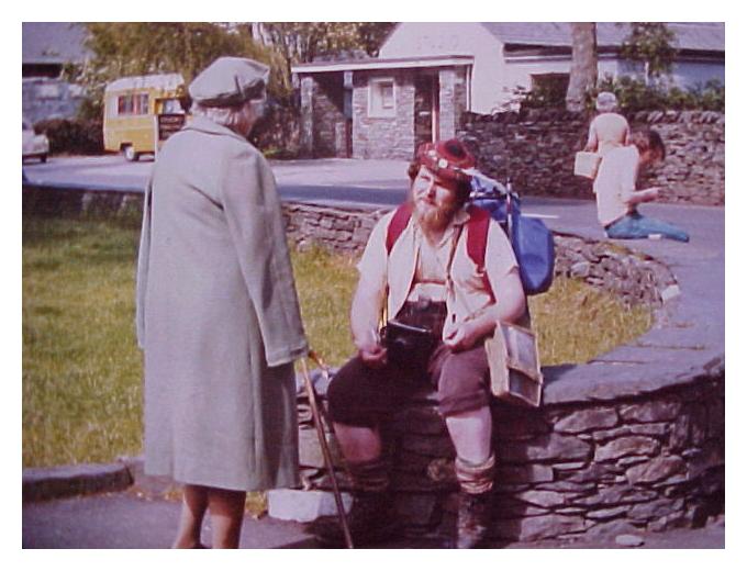
After two days of gruelling long distance walking, I decided I would take things easy today and settle for nearby Patterdale, rather than an uncertain continuation to Shap, which would involve passing through unknown fell country too late in the day for comfort! I took time to explore Grasmere in the morning. Sitting on a bench with crook, staff, touring pack and a grizzled appearance, I found myself being photographed by two mature ladies who must have fancied me a 'character'! Observing my holed pebble, one of them remarked that such things could be could be used as a channel for psychic energies - for dowsing. Also that I should write to the Times about the current situation of British Education.! I gave them my address so they could send me copies of the photograph, which they later did!
In short, I left Grasmere at 11 am and plodded up the Grizedale Pass, passing a 'beware of Adders' notice. I arrived at Patterdale at 4.15, having abandoned the possibilities both of Helvellyn and St. Sunday Crag due to the excessive summer heat.It was certainly not weather for serious walking, as my water canteen clanged and salt deposited itself on my sweating face. The Grizedale Pass seemed more like the Khyber, or the road to some Foreign Legion outpost! Relief came only with the shady glades of Patterdale. I arrived at the Youth Hostel in the company of a young cyclist from Warwick. After taking a shower I descended on the local pub
. On the way down a red squirrel darted across the road and into a tree, but after allowing me to focus my camera on it, darted off just as I was about to press the shutter! After pies and a pint at the pub, I finally turned in, after a day more gruelling than I had expected.
Fourth Day. 6.6.73.Patterdale to Shap.
Hot and sunny in Patterdale as I climbed steeply out of the valley in the direction of the Angle Tarn sucking a succession of lemon flavoured boiled sweets. I was perspiring profusely, I recall but the ascent turned out to be not exceptionally arduous. Beyond Angle Tarn I encountered an elderly walker from Liverpool, and together we ascended to the summit of Kidsty Pike. I must have looked in a bad way, as on the summit of Kidsty Pike, surrounded by annoyingly buzzing flies, he shared his lunch with me, for which I, being ill provisioned, was very grateful! To the right lay the great bulk of High Street, its roman road clearly visible Ahead lay Hawes water, sombre in contrast to the lovely lakes of Brothers Water and Hayes Water above which we had just passed. We parted, and as my temporary companion gradually disappeared back in the direction of Patterdale, it occurred to me that I would soon be saying farewell to the lovely mountains and dells of Lakeland.
In the distance beyond my immediate route to Shap I could make out the flat, hazy outline of the Pennines. Even these eastern Lakeland fells now seemed somehow to have an almost Pennine grassiness about them - rolling bare slopes rather than rocky crags and defiles. I felt sad to be leaving the Lake District, and as I descended the undefined route to the head of the lake, to alive at Mardale Head I felt even sadder.
Here, somewhere under the lake, is the village of Mardale, submerged when Haweswater was made into a reservoir to supply thirsty Manchester. The water level was low and you could make out the remains of eroded drysone walls descending into the peaty darkness of the lake. Saddened, I imagined I might hear the bells of Mardale Church, but there was no sound - save the bleating of sheep!
It was now getting late again, and the walk along the edge of Haweswater was tiring. At one point I noticed my compass was missing, and retraced my steps for a quarter of a mile in search of it. I found it on a rock. At a footbridge by a lovely little tree shaded cascade I stopped to rest and drink, then closing a small wooden gate behind me, I bade the Lakes a ritual farewell..
Before reaching Burn Banks at the edge of the lake, I encountered two wild ponies. Dirty and dishevelled their manes were shaggy and their tails dragged on the ground. They eyed me with a wary distaste. They were free, and knew it.
Beyond Burn Banks I congratulated myself on finding a particularly elusive stile, but ten minutes later I was hopelessly lost, and after thirteen hot miles I was tired, and wishing to call it a day. After much fence climbing and detouring, I finally reached the river, and was able to trace a route up to Rosgill Bridge, shadowed by a cheeky hare on the opposite bank. From there, passing Shap Abbey I finally made Shap at the hideous time of 8.30pm. But my trials were still not over. Shap straddles a dreary road now bypassed by the M6 motorway . To my surprise I was unable to find accommodation. On the sixth attempt after a tarmac slog through the village, just as I was contemplating the merits of sleeping under a wall, I finally managed to get a bed at the Greyhound Hotel, at a price well over my budget. During the night, I was sick. Hot, aching and tired, I felt thoroughly depressed. This was surely the lowest point on my journey. Surely it couldn't get any worse? The following day was to prove me wrong!!
Fifth Day. 7.6.73.Shap to Kirkby Stephen.
This was probably the worst day in the whole journey. The countryside was lovely, but navigation awkward at times. It was excruciatingly hot, and, quite unlike Lakeland, there was no surface water anywhere. I was to walk 15 miles without a drink to a late and exhausted arrival in Kirkby Stephen. This section is a 21 miles crossing of the Westmoreland Limestone plateau. Limestone clints are in abundance, and the area is a delight for the archaeologist and the botanist, but I very quickly found myself in no mood to be much of either!! I left Shap rather late, certainly well after two blokes I had met the night before, who were also heading for Kirkby Stephen. Starting to develop blisters now, I crossed fields from Shap to the footbridge over the motorway, and then to the edge of a ghastly granite quarry. At Oddendale came the first highlight of the journey - a splendid stone circle standing boldly on the moor with the spur of Kidsty Pike framed on the western horizon. Next came a tumulus, some interesting erratic boulders, then the Lyvennet Beck - an almost dried up sludgy trickle where a monument proclaims that at this spot Charles II regaled his army. It must have been a very small one that's all I can say!!
Next, after a trail of dead sheep, I arrived hot and thirsty at the cairn known as Robin Hoods Grave, an insult to Kirklees Priory if ever there was one! By the road junction near the clints of Beacon Hill I drank my last can of fizz. Beyond the jubilee monument I negotiated a difficult path across to Castle Folds. Here, very tired, and by now hot and thirsty, I got hopelessly lost. At this point I noticed that my holed pebble was missing from around my neck, the knot having parted. A search for it proved fruitless, and retracing my steps was definitely not an option! It remains there still. My next objective was Subiggin Tarn, and seeing a glint of water far below, I headed straight for it. After striding over a small fence, Which I suddenly realised was electrified, and being shadowed and nudged by a herd of over curious young bovines I finally reached my objective to find a foetid reedy pond inhabited by hundreds of decidedly unfriendly gulls! An elderly couple nearby offered me a cup of some water they had bottled for their car radiator, but the effect of that was soon lost .
Springs shown on the map were quite invisible on the ground, as I plodded over seemingly endless moor to the site of the Severals Village Settlement. Here there is little to see but a few low mounds, indeed you could walk right through the middle of it and not notice it was there. Eventually I reached the Scandal Beck, near the railway . It looked sudsy and polluted. I worked by way down the beckside to Smardale Bridge, where I managed to pick up the route again. By now I was half dead and still seemingly miles from anywhere. The walk over the next hill would not normally be particularly difficult, but in my condition it seemed arduous in the extreme! On the other side of the hill I saw a cattle trough set into a nearby wall - Salvation!!! Attached to it was a stopcock and a tap. I drank my fill and filled every container I was carrying. An hour later I finally arrived in Kirkby Stephen to the welcome of a barking dog, the heel flapping off my boot! I arrived at the Youth Hostel (which is part of a Quaker Meeting House), to find no warden in residence, merely a message to visitors to settle in and see to the formalities in the morning! This I did. At a nearby pub I met the two blokes I had stayed with in Shap. They too had been exhausted, and had drunk from the same stopcock as I! One was going home to Blackpool the following day, the other, Ian, who was also walking the Coast-to-Coast, informed me he would be setting out for Reeth first thing in the morning. But not me - now having nothing to wear on my feet but sandals, I would have to get my hiking boots sorted pronto. Come morning I would be seeking out the nearest cobblers!
Sixth Day. 8.6.73.Kirkby Stephen to Reeth.
Morning I took my boots to the cobblers and explained the situation. The cobbler was a very friendly chap and I was relieved when he told me he would have them repaired in less than an hour . It would only be a temporary repair, mind, but it should see me through to the end of my journey. I was sad to leave Kirkby Stephen, it was a pleasant town and a good place for licking wounds, but by late morning I was on my way once more.
Being so late in starting, and still feeling the effects of the previous day, I decided it would be wise to give myself an easy walk by missing out the route over Nine Standards Rigg and simply following the quiet fell road to Keld, where I would check into the youth hostel there. I set off with a will, and after a few miles of ascent reached the Yorkshire County boundary sign on top of the Pennines, curiously surrounded by a rash of old boots!. From here the rivers would all flow east to the North Sea. It would be the home county all the way to Robin Hoods Bay! Suddenly I was crossing the watershed and everything felt like it would now be downhill all the way! I was exhilarated and my morale restored! I sped off down the hill into Swaledale with a new sense of purpose.
After some hours of tarmac beating I reached Keld around 4.45pm, only to find a coachload of schoolkids at the youth hostel, and no bed available for me - the only card carrying member there! I felt like tearing my card up in disgust.
There was nowhere else to stay in Keld. Best I could do would be to keep going. The long upland sections through the leadmines above Swaledale would have to wait for another expedition, as heading up into the hills at this time of day might invite disaster should I be up there at nightfall.
So I continued on the fell road down the valley, cheering up a bit as I passed through Thwaite. At Gunnerside, which I reached around 8pm a nice old chap invited me into his cottage for a pot of tea, and in the company of an old clock on the wall and his flickering TV we enjoyed a pleasant conversation. He informed me that John Wesley had once lodged in this cottage during the course of his evangelical wanderings. Afterwards I continued on my seemingly interminable way, finally arriving in Reeth at about 10pm, hardly able to stand. Here I was able to secure a bed immdiately at the Buck Hotel. I took a bath, then relaxed in the bar for what little evening I had left, shattered but in good spirits. Tomorrow would be an easy trip on to Richmond, and having made Reeth I was now well back on schedule.
Seventh Day. 9.6.73. Reeth to Richmond.
After a gargantuan Dales breakfast in the Buck, I hitched up my pack and set off for Richmond, sad in a ay to be moving on, for Swaledale was undoubtedly the friendliest place on the whole walk, despite the disappointment at the youth hostel. I passed by Marrick Priory, noticing the amusing notice on the gate, ad passed through a wood to the hamlet of Marrick, with its chapel and church and incongruous new telephone kiosk. The sundial lauded by Wainwright seemed to me to be a very grotty affair. Beyond Marrick, indistinct and occasionally impassable footpaths made the going both confusing and difficult. At Marske (where a bench proclaims 'Best Kept Village of 1971) I caught up with Ian from Shap, who was surpised to see me, thinking me still back at Keld. Together we walked through this lovely valley, beneath Whitcliffe Scar towards Richmond, Willances' Leap on our left. At Clapgate Beck near Marske, my new found companion nearly soaked himself trying to ford it. Happily I found a bridge a few yards further upstream!
We rounded a bend and a beautiful sight met our eyes- below us Richmond, with its stern, dominating castle, and beyond, the lush plain of the Vale of Mowbray. And even further off, on the far horizon, we could make out the long, low outline of the Cleveland Hills, a sight long awaited. I now suddenly began to feel that I was getting somewhere. It was teatime,, and after basking in the sun for some time in Richmond Castle Yard, I succeeded in getting lodging in a georgian terrace house on Frenchgate, right next door to my my new companion. In the evening we explored Richmond, and went to the pub. Richmond is a town beautiful and unspoilt. Perhaps its location in a position unbuffetted by the tumult of history has kept it so. We saw most of Richmond's 'sights', but the famed 'dogs toilet'proved elusive. It would be hard to say goodbye to Richmond.
Eighth Day. 10.6.73. Richmond to Ingleby Cross.
This section was undoubtedly the least interesting of the whole journey, twenty three miles of invisible footpaths, blocked stiles, interminable hedgerows, over curious livestock and an unending ribbon of blistering metalled country roads. The route to Catterick Bridge, unpromising enough, began by a sewage farm and after vain attempts to find ill defined footpaths, terminated on a busy A class road. I don't know why the soldiers at Catterick Camp commandeer the moors for their exercises - every local farmer has an assault course ready made! A farmer we met by the ruinous Hagg Farm, was more than stunned to find the old place was actually illustrated in a book!
Bolton -on-Swale (Best Kept Village of 1967) was a pleasant but brief respite. The most interesting thing here is the crooked, pointed memorial in the churchyard to the memory of Henry Jenkins, whose unique acheivement was to live to the age of 169. Beyond lay road - hot, sweaty, pounding endless and exasperating! Noth here of interest to anyone but farmers. At Danby Wiske, Wainwright's 'Slough of Despond', people look at you as if you are insane! Next comes a maze of more unfindable footpaths, starting in a grassy lane overgrown like the Amazon rain forest! At this point we increasingly began to realise just how 'virgin' our route was, and felt somewhat privileged to be almost certainly the only people walking it at his time. But it did little to alleviate our exasperation with the Vale of Mowbray!
Next came a farm road, leading to the blocked footpath that had prompted Wainwright to complain to the North Yorkshire County Council. We had considered avoiding it by following the main road, but when we reached the start of it it seemed that action had been taken - a shiny new 'public footpath' sign pointed the way - so off we strode - straight into the barbed wire, electric fences and threatening livestock mentioned by Wainwright. We quickly realised the councils response to his complaint had been to erect a spanking new footpath sign - and nothing more! Exasperated we retraced our route back to the road. Our next sally over open country took the form of an arable field, not any old field, but a nightmare straight from the Great Plains of North America! It seemed longer than the whole route combined!
Eventually we reached the Bluebell at Ingleby Cross, where after securing accomodation we treated ourselves to a ham and egg supper. That night I slept like a log, I was so exhausted. We had expected a rough day, and that was exactly what we got!
Ninth Day. 11.6.73. Ingleby Cross to Danby High Moor.
After a hearty breakfast we checked out of the Bluebell and began the steep ascent up through the forest to the dishes and wire minarets on the booster station on Scarth Wood Moor. The first upthrust of the Cleveland Hills from the flatlands of the Vale. As we climbed, the flat landscape of the Vale of Mowbray disappeared into the western haze, like some giant patchwork quilt. Beautiful as it was, had someone suggested retracing our steps back to Richmond, we would have turned our noses up in disdain. We were now on the last lap and we knew it. Passing througha gate, we made our way to the concrete Trig. Point on Scarth Wood Moor, that marks the official start of the Lyke Wake Walk.
Now a different landscape appeared before us - rolling heather moors, stretching as far as the eye could see, steep escarpments leading to a distant moorland plateau. The Lyke Wake walk was clearly in view, a stony, eroded , fawn coloured ribbon, created by the feet of hundreds of walkers. It looked easy. We set off with a will over the moor, but our route soon turned into an exasperating descent into Scugdale, losing most of the height gained. Beyond Scugdale my left knee kept giving way, and I was slowing painfully (A weakness I was to rediscover again some years later on the Southwest Peninsular Coastal Path). Ian was making for the Lion at Blakey, where he had arranged for a friend to pick him up, so we parted company. I never saw him again. As he faded away into the distance, I plodded slowly on past the gliding club on Cringle Moor. The weather was fine, but on the tops a gale was blowing. Resting at the viewfinder on Cringle End, I could see the industrial landscape of Middlesborough away to the north. My leg was hurting and after the long slog out and up to Cringle End I quickly began to realise that the Cleveland Hills were an up and down switchback all the way to the fell road at Clay Bank Top. Every time I breasted a hill, we found myself looking at yet another descent and subsequent ascent to the next summit. It was torture!
Further along the route I met a scouting type from Hull, who was walking the Cleveland Way. We sheltered from the wind at Wainstones, and as we walked and talked we made good time, the company restoring my spirits. Beyond Hasty Bank we reached the road at Clay Bank Top, and after an uphill slog to the Handstone on Urra Moor the Cleveland Hills finally give way to easier going on the high upland plateau of the North Yorkshire Moors. A short distance further on we reached the gate by the disused railway embankment at Bloworth Crossing, where we parted company, my temporary companion branching off to the north east, along the Cleveland Way.
I continued onwards along the Lyke Wake Walk, following the long grassy track where trains had once
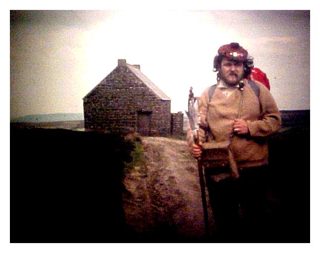
plied the Rosedale Ironstone Railway. My limp had now gone, and the pain had subsided. The walking was now easy, but surrounded on all sides by desolate, inhospitable moorland without a building in view on any horizon, I felt lonely and far from home. As I played at trains I became increasingly aware of how endless a disused railway line can be. Long straight stretches followed by bends winding round hillsides to further straight stretches. Views of Farndale, far below on the right, only served to increase my desire to get my by now near exhausted frame to a comfy, warm bed as quickly as possible. After and eternity of walking, and a brief shelter from the wind in a disused water tower, I finally reached the road and the Lion Inn at Blakey, only to find that the place wasn't residential and was also ten moorland miles away from the nearest village! As it was now 7.30 pm and I was near done in, I decided that my best bet in this situation would be to push on up the route and try to spend the night at the Trough House, a shooting hut on Danby High Moor which Wainwright describes in the Guide. Failing that, if the place was locked, it would have to be the last resort of a bivi bag in the heather.
I pushed on, hoping I could make the place before dark, as there were no other buildings in miles. On the road I encountered a dead lamb, still warm, its mother standing nearby looking dazed and bewildered. In my tired state it both angered and upset me. I trudged on, part of the Fylingdales 'Golfballs' coming into view in the distance. At White Cross, the Coast-to-Coast Walk leaves the Lyke Wake Walk to go its own way, and I branched off onto Danby Moor, the sun now starting to sink below the horizon. It was dusk when I reached the Trough House, a tiny hut in the middle of a vast moor. Apprehensively I tried the door. It was not locked. Inside I found bare, whitewashed walls and a rough table with wooden benches. The building was in good shape, but litter and a smashed window revealed that others less conscientious than I had sojourned there. There was a stone fireplace and a chimney, so I gathered up some heather and with the aid of some paper sacks lit a fire in the hearth. The heather crackled and my shadow appeared gigantic on the now darkened walls, sihouetted in an orange glow, as the wind howled through the shattered windows and gaps in the fabric. I had a drink, and consumed the last of my rations, then made my bivouac on the long table. The table was hard, and although my tired limbs found some rest, sleep seemed impossible. The wind howled and rattled the door, and every so often the smouldering heather would flare up in the fireplace, jerking me into wakefulness. I took stock. Since leaving Ingleby Cross I had walked 24 miles.
Tenth Day. 12.6.73. Danby High Moor to Grosmont.
I finally got up at 6am. The bivi had been hot and sweaty, and my youth hostel sleeping sack inside the polythene bag was damp with condensation. I was still desperately tired. It was dawn, but outside the moors were invisible under a thick bank of rolling mist. To venture onto open moor in this murk would be tempting fate , so I decided to stay put for a while and wait developments.
I dozed for a while and was roused by a solitary bumblebee, seeking shelter from the buffetting wind outside.By 8am the fret had lifted slightly and the sunlight was filtering through the mist, though the wind was still blowing fiercely. I ventured out and continued on my way.
A long slog down Danby Moor eventually met up with the track on Glaisdale Rigg, which I followed down to Glaisdale Head, half falling asleep on my feet. After squeezing myself and my pack in and out of a tiny public loo in Glaisdale, I had a much needed drink in the Mitre Tavern. The landlord there had apparently met Wainwright when he was compiling the route, and an interesting conversation ensued.
Leaving the Mitre I pushed on past 'Beggars Bridge' to Egton Bridge where I just crashed out by the wayside in a state of sheer exhaustion. I recovered a little, and hobbled on towards Grosmont. I was in a daze, my eyelids were heavy and the whole situation was starting to feel unreal. I staggered into Grosmont at 2pm, now only fifteen miles from Robin Hoods Bay; but I simply couldn't go any further!
Ascending out of Grosmont I found a B&B lodging and asked for a room. (I don't think I could have made the top of the hill!) I sat down on a settee in the company of a large dog, while the lady brought me some tea. Five minutes later, when she came back for the cups she found me asleep! I awoke at teatime, feeling much better, but still weary and went for a stroll into the village. After watching the steam locos on the preserved railway I retreated to the pub, where, in the company of the landlady's attreactive daughter and a burly geordie lorry driver I learned that my erstwhile companion Ian had passed through during the afternoon. I retired early to bed, having lost a day and now regretting it. I slept like the proverbial log!
Eleventh Day. 13.6.73. Grosmont to Robin Hoods Bay.
At last the big day had arrived! The morning was sunny, but still fiercely windy. I left my lodging after a superb breakfast, and feeling like a new man I marched up the steep hill out of Eskdale. I had not been walking more than ten minutes when a wonderful sight met my eyes! As I breasted the summit of the hill, there, shining radiantly blue in the distance I could make out the North Sea, with Whitby Abbey on its clifftop in clear view. Rainbows end was in sight at last. I was excited and inspired, realising that all the days of endless footslogging had not been in vain. Crossing open moor I reached two ancient burial mounds commanding a superb view over the coast. The prize was almost in my grasp!
But things are never that simple. My legs were already aching, and, for the first time on this long journey I was getting blisters on my feet and the back of my heels. The last lap was going to be not so much a march as a hobble!
First came the descent to Littlebeck, a stream as picturesque as its name. Then the Falling Foss nature trail, numerous side paths making route finding difficult. At length I climbed to the Hermitage, a folly pavilion carved out of the living rock of a gigantic boulder. On top of the boulder two chairs have been carved - one for a man and one for a child. Beyond lay Falling Foss itself, a pretty waterfall reduced to a mere trickle by the dry spell. After negotiating a marsh I emerged at a car park, then eventually I passed onto open moor, my blisters now killing me. Near a plantation a long track wound on to Hawsker, with a magnificent view of Whitby Abbey and the sea on the left.
Hawsker proved to be an east coast copy of Sandwith. Lingering not I passed a caravan site and emerged onto the clifftop at Maw Wyke Hole. I was enthralled at this point, but rather unnerved with the gale force winds that threatened to gust me into the sea! The numerous stiles along the clifftop played havoc with my aching legs, and after a steep descent down a dusty slope I suddenly realised how gigantic these rolling east coast cliffs are.
Rounding a headland I entered Robin Hoods Bay. I could see the Bay Town ahead, a cluster of tiny red roofed dolls houses perched on the edge of a precipice. Even further afield, faint yet visible I could make out the chalk headland of Flamborough Head. It was there the american privateer John Paul Jones had fought his famous sea battle in the U.S.S. Bonhomme Richard. It seemed strange that he had also raided Whitehaven and spiked the guns there, in full view of St. Bees Head. Robin Hood was not the only hero associated with this walk. As I approached the Bay Town I ran into trouble in the form of two infernal kissing gates. (anyone who has tried to pass through one carrying a large pack will know why I call them 'infernal'.) Finally, reaching the suburbia that forms the hinterland of the Bay Town, I girded up my loins for the last push, and proceeded with a somewhat hobbling decorum down the narrow street that winds down through pantiled fishermens cottages to the sea. Reaching the sea I walked straight into it- soaking myself in a ritual of completion! Then I closed the book!!
Epilogue. Some Comments and reflections.
Walking straight out of the sea into the nearest bar, I met a rather dignified gentleman, who, hearing of my journey, bought me a pint! He was a Lakeland walker, and told me of fine rambles in the Western Fells in the days before tourism became big business. Sitting outside the Bay Hotel, the wind still buffetting, and white capped waves lashing the sea wall, I reflected and talked. My drinking companion had designs on the Pennine Way, but after he heard of my exploits seemed to be falling increasingly in love with the idea of walking coast-to-coast. We parted and I sought a bed for the night. I obtained a room at the Dolphin Hotel, and inside the bar, as I came down, I encountered the man I had just met telling the assemble company of my exploits! Afterwards I spent a relaxing evening sitting by the sea. I thought of Ian, who had got here first, but whom I was fated never to see again. Next morning, therefore, I was more than surprised, when ascending the street to catch the bus out of Robin Hoods Bay, I bumped into his companion whom I had accompanied from Shap to Kirkby Stephen! While I had been plodding onwards towards Robin Hoods Bay he had returned home to Blackpool, spent a further day or two in the Lakes, and then had come to Whitby, visiting the Bay on a fossil hunting expedition! He was the last person I would have expected to bump into! What a small world!
So it was over. Sitting by the sea, and riding home on the bus I had time to reflect. I had just had an adventure on what must surely be the finest long distance footpath in Britain. The Lake District, The Yorkshire Dales and the North Yorkshire Hills all in one walk, with a beach at either end! What more could anyone possibly want? The Pennine Way could only be a bleak and dreary bore after it. Its diversity alone puts other routes to shame! And what did I prove? What did I learn?? If anything, that success is never impossible if you try hard enough, smile at adversity and willingly sacrifice a little of yourself in the process. If you doubt your ability to succeed in life a walk like this will prove it one way or the other. It demands everything and gives nothing. You wont find a crock of gold at your personal rainbows end, but you might find YOURSELF..
Jim Jarratt.

This is the story of a Coast-to-Coast walk. The walk that culminated in the Pathfinder. I walked Wainwrights now famous long distance footpath from St. Bees Head to Robin Hoods Bay in eleven days, but a strong walker would do it in less. What follows here is not so much a guide to the walk, but rather the story of one mans impressions and experiences in walking it. The Coast-to-Coast is a tough walk of around 190 miles, exhilarating sometimes, exasperating at others! For variety it puts the Pennine Way to shame. The country is perfect - traversing high ground for most of the way it crosses the Lake District, The Westmorland Limestone Plateau, The High Pennines, the length of Swaledale, the Vale of Mowbray, the Cleveland Hills and the North Yorkshire Moors. On my crossing I was lucky- the weather was excellent. The hills of Northern England are not always so.
First Day. 3.6.73. St Bees to Gillerthwaite.
' A fine start to such an adventure' I thought As I ate my breakfast in the basement dining room at Tomlin House, St. Bees, watching the raindrops trickle down the window panes, beyond which lay a thick murk over the Irish Sea. The previous day I had disembarked from a coach in Keswick in brilliant sunshine, caught a bus to the rather less hiker friendly town of Whitehaven, and then found myself having to wait two hours to catch a bus to St. Bees., by which time it was raining. It was now morning, and the rain hadn't stopped. My proposed journey had aroused much interest in the boarding house. They didn't see much in the way of hikers hereabouts, the boots-and-rucksack set tended to stay in the Lake District in this county. St Bees was a place for caravans, buckets and spades.
Making my farewells I set off on my adventure. I didn't get far - the rain was torrential and within a few hundred yards I was sheltering under a kiddies slide in the nearby playground, awaiting a break in the weather.
I didn't have to wait too long. The rain eased, and as I crossed the footbridge over the little beck and climbed the steep path alongside the fence onto St. Bees Head, the sun came out and sparkled on the damp grass, as seabirds wheeled around this lofty bulwark of brown sandstone that justs out into the Irish Sea. As I climbed, the view opened up and I could see the Isle of Man out at sea, the serrated skyline of the Western Fells of Lakeland, and to the north west, the Galloway Hills across the Solway Firth - exhilarating views!
I descended to the Beach at Fleswick Bay, a steep and narrow cleft between the cliffs of the North and South Head. Anglers were sitting on the pebbles alongside their beach rods. Idly beachcombing, I found a small pebble with a hole in it and a piece of fluorescent orange fishing net twine. I threaded the pebble with the line and tied it round my neck. I was going to take this bit of the Irish Sea to Robin Hoods Bay! I wet my boots in the sea for the last time. All being well my boots would next touch seawater in the North Sea - yes this WAS going to be an adventure!
After a rock scramble at Fleswick Bay I walked along the North Head to St. Bees Lighthouse, at which point I finally turned inland - now the walk was underway with a vengeance! At Sandwith I enjoyed a pint in pleasant company before continuing once more on my way. Before me the mountains and the industry of Whitehaven on my left. Barbed wire, hedghogs and a filthy marsh to contend with at Stanley Pond, a reedy pool in a dismal hollow below a railway track. Passing through Moor Row and Cleator I decided to follow a farm road through to Ennerdale Bridge, missing the green fell of Dent from the itinerary - a sound decision as it turned out. The afternoon was hot and the walk to Ennerdale Bridge a sweating blistering slog. I arrived there about 5pm, consuming a bottle of pop with relish. This should have ended the day on my route timetable but I was aiming for the Youth Hostel at Gillerthwaite - four miles further on, making a sum total of nineteen miles on my first day. After following the right bank of Ennerdale Water and scrambling around the Anglers Crag, I followed the rocky and seemingly interminable path to the Lake head. Evening was drawing in and cuckoos were singing in the trees around. At the end of the lake I missed the footbridge over the Liza, which flows into the lake, and it took a wet, frustrating slog to get to it. Making the forest road I arrived at Gillerthwaite, shattered but satisfied at seven pm. Gillerthwaite, with its calor gas lighting and dark surrounding forest was a fitting end to a long day. I was soon asleep.
Second Day. 4.6.73. Gillerthwaite to Grasmere.
Long uneventful slog up the forest road from Gillerthwaite. Monotony relieved by the odd glimpse of Pillar Rock. Beyond Black Sail Hut at the rock strewn head of the dale, the path ascends Loft Beck up to the Brandreth Fence between Ennerdale and Honister. Superb views - particularly of Buttermere Valley. After meeting some ramblers bound for Great Gable descended the steep path to the slate works at the head of Honister Pass. Descended to Seatoller with lovely views all the way. From Seatoller passed through Johnnys Wood to the Hostel at Longthwaite. En route met a shepherd with his dogs who remarked that if the wooden crook I had was caught in a rainstorm it would go straight! I was amused by this, until some months later, when he was proved right!
It was now four thirty and I was till only half way to Grasmere, having walked ten Lakeland 'miles, in blistering weather. Ahead lay a long ramble up Greenup Gill, dominated by Eagle Crag, followed by a steep and taxing scramble up to Greenup Edge. I reached the top at 6pm, and rested awhile. The view was marvellous- a pyramidical Skiddaw in the evening sunlight, towering over the the silvery shimmer of Bassenthwaite. Far to the southeast I could make out the distant shape of Ingleborough, evoking memories of other rambles, nearer home. By this time I was really exhausted, and can remember little of the seemingly endless descent that took me to Grasmere via Far Easedale. Nevertheless, after arriving at the Youth Hostel , I recovered sufficiently to make myself a supper from a tin of stew, in the company of four Americans touring the lakes.
Third Day. 5.6.73. Grasmere to Patterdale.
After two days of gruelling long distance walking, I decided I would take things easy today and settle for nearby Patterdale, rather than an uncertain continuation to Shap, which would involve passing through unknown fell country too late in the day for comfort! I took time to explore Grasmere in the morning. Sitting on a bench with crook, staff, touring pack and a grizzled appearance, I found myself being photographed by two mature ladies who must have fancied me a 'character'! Observing my holed pebble, one of them remarked that such things could be could be used as a channel for psychic energies - for dowsing. Also that I should write to the Times about the current situation of British Education.! I gave them my address so they could send me copies of the photograph, which they later did!
In short, I left Grasmere at 11 am and plodded up the Grizedale Pass, passing a 'beware of Adders' notice. I arrived at Patterdale at 4.15, having abandoned the possibilities both of Helvellyn and St. Sunday Crag due to the excessive summer heat.It was certainly not weather for serious walking, as my water canteen clanged and salt deposited itself on my sweating face. The Grizedale Pass seemed more like the Khyber, or the road to some Foreign Legion outpost! Relief came only with the shady glades of Patterdale. I arrived at the Youth Hostel in the company of a young cyclist from Warwick. After taking a shower I descended on the local pub
. On the way down a red squirrel darted across the road and into a tree, but after allowing me to focus my camera on it, darted off just as I was about to press the shutter! After pies and a pint at the pub, I finally turned in, after a day more gruelling than I had expected.
Fourth Day. 6.6.73.Patterdale to Shap.
Hot and sunny in Patterdale as I climbed steeply out of the valley in the direction of the Angle Tarn sucking a succession of lemon flavoured boiled sweets. I was perspiring profusely, I recall but the ascent turned out to be not exceptionally arduous. Beyond Angle Tarn I encountered an elderly walker from Liverpool, and together we ascended to the summit of Kidsty Pike. I must have looked in a bad way, as on the summit of Kidsty Pike, surrounded by annoyingly buzzing flies, he shared his lunch with me, for which I, being ill provisioned, was very grateful! To the right lay the great bulk of High Street, its roman road clearly visible Ahead lay Hawes water, sombre in contrast to the lovely lakes of Brothers Water and Hayes Water above which we had just passed. We parted, and as my temporary companion gradually disappeared back in the direction of Patterdale, it occurred to me that I would soon be saying farewell to the lovely mountains and dells of Lakeland.
In the distance beyond my immediate route to Shap I could make out the flat, hazy outline of the Pennines. Even these eastern Lakeland fells now seemed somehow to have an almost Pennine grassiness about them - rolling bare slopes rather than rocky crags and defiles. I felt sad to be leaving the Lake District, and as I descended the undefined route to the head of the lake, to alive at Mardale Head I felt even sadder.
Here, somewhere under the lake, is the village of Mardale, submerged when Haweswater was made into a reservoir to supply thirsty Manchester. The water level was low and you could make out the remains of eroded drysone walls descending into the peaty darkness of the lake. Saddened, I imagined I might hear the bells of Mardale Church, but there was no sound - save the bleating of sheep!
It was now getting late again, and the walk along the edge of Haweswater was tiring. At one point I noticed my compass was missing, and retraced my steps for a quarter of a mile in search of it. I found it on a rock. At a footbridge by a lovely little tree shaded cascade I stopped to rest and drink, then closing a small wooden gate behind me, I bade the Lakes a ritual farewell..
Before reaching Burn Banks at the edge of the lake, I encountered two wild ponies. Dirty and dishevelled their manes were shaggy and their tails dragged on the ground. They eyed me with a wary distaste. They were free, and knew it.
Beyond Burn Banks I congratulated myself on finding a particularly elusive stile, but ten minutes later I was hopelessly lost, and after thirteen hot miles I was tired, and wishing to call it a day. After much fence climbing and detouring, I finally reached the river, and was able to trace a route up to Rosgill Bridge, shadowed by a cheeky hare on the opposite bank. From there, passing Shap Abbey I finally made Shap at the hideous time of 8.30pm. But my trials were still not over. Shap straddles a dreary road now bypassed by the M6 motorway . To my surprise I was unable to find accommodation. On the sixth attempt after a tarmac slog through the village, just as I was contemplating the merits of sleeping under a wall, I finally managed to get a bed at the Greyhound Hotel, at a price well over my budget. During the night, I was sick. Hot, aching and tired, I felt thoroughly depressed. This was surely the lowest point on my journey. Surely it couldn't get any worse? The following day was to prove me wrong!!
Fifth Day. 7.6.73.Shap to Kirkby Stephen.
This was probably the worst day in the whole journey. The countryside was lovely, but navigation awkward at times. It was excruciatingly hot, and, quite unlike Lakeland, there was no surface water anywhere. I was to walk 15 miles without a drink to a late and exhausted arrival in Kirkby Stephen. This section is a 21 miles crossing of the Westmoreland Limestone plateau. Limestone clints are in abundance, and the area is a delight for the archaeologist and the botanist, but I very quickly found myself in no mood to be much of either!! I left Shap rather late, certainly well after two blokes I had met the night before, who were also heading for Kirkby Stephen. Starting to develop blisters now, I crossed fields from Shap to the footbridge over the motorway, and then to the edge of a ghastly granite quarry. At Oddendale came the first highlight of the journey - a splendid stone circle standing boldly on the moor with the spur of Kidsty Pike framed on the western horizon. Next came a tumulus, some interesting erratic boulders, then the Lyvennet Beck - an almost dried up sludgy trickle where a monument proclaims that at this spot Charles II regaled his army. It must have been a very small one that's all I can say!!
Next, after a trail of dead sheep, I arrived hot and thirsty at the cairn known as Robin Hoods Grave, an insult to Kirklees Priory if ever there was one! By the road junction near the clints of Beacon Hill I drank my last can of fizz. Beyond the jubilee monument I negotiated a difficult path across to Castle Folds. Here, very tired, and by now hot and thirsty, I got hopelessly lost. At this point I noticed that my holed pebble was missing from around my neck, the knot having parted. A search for it proved fruitless, and retracing my steps was definitely not an option! It remains there still. My next objective was Subiggin Tarn, and seeing a glint of water far below, I headed straight for it. After striding over a small fence, Which I suddenly realised was electrified, and being shadowed and nudged by a herd of over curious young bovines I finally reached my objective to find a foetid reedy pond inhabited by hundreds of decidedly unfriendly gulls! An elderly couple nearby offered me a cup of some water they had bottled for their car radiator, but the effect of that was soon lost .
Springs shown on the map were quite invisible on the ground, as I plodded over seemingly endless moor to the site of the Severals Village Settlement. Here there is little to see but a few low mounds, indeed you could walk right through the middle of it and not notice it was there. Eventually I reached the Scandal Beck, near the railway . It looked sudsy and polluted. I worked by way down the beckside to Smardale Bridge, where I managed to pick up the route again. By now I was half dead and still seemingly miles from anywhere. The walk over the next hill would not normally be particularly difficult, but in my condition it seemed arduous in the extreme! On the other side of the hill I saw a cattle trough set into a nearby wall - Salvation!!! Attached to it was a stopcock and a tap. I drank my fill and filled every container I was carrying. An hour later I finally arrived in Kirkby Stephen to the welcome of a barking dog, the heel flapping off my boot! I arrived at the Youth Hostel (which is part of a Quaker Meeting House), to find no warden in residence, merely a message to visitors to settle in and see to the formalities in the morning! This I did. At a nearby pub I met the two blokes I had stayed with in Shap. They too had been exhausted, and had drunk from the same stopcock as I! One was going home to Blackpool the following day, the other, Ian, who was also walking the Coast-to-Coast, informed me he would be setting out for Reeth first thing in the morning. But not me - now having nothing to wear on my feet but sandals, I would have to get my hiking boots sorted pronto. Come morning I would be seeking out the nearest cobblers!
Sixth Day. 8.6.73.Kirkby Stephen to Reeth.
Morning I took my boots to the cobblers and explained the situation. The cobbler was a very friendly chap and I was relieved when he told me he would have them repaired in less than an hour . It would only be a temporary repair, mind, but it should see me through to the end of my journey. I was sad to leave Kirkby Stephen, it was a pleasant town and a good place for licking wounds, but by late morning I was on my way once more.
Being so late in starting, and still feeling the effects of the previous day, I decided it would be wise to give myself an easy walk by missing out the route over Nine Standards Rigg and simply following the quiet fell road to Keld, where I would check into the youth hostel there. I set off with a will, and after a few miles of ascent reached the Yorkshire County boundary sign on top of the Pennines, curiously surrounded by a rash of old boots!. From here the rivers would all flow east to the North Sea. It would be the home county all the way to Robin Hoods Bay! Suddenly I was crossing the watershed and everything felt like it would now be downhill all the way! I was exhilarated and my morale restored! I sped off down the hill into Swaledale with a new sense of purpose.
After some hours of tarmac beating I reached Keld around 4.45pm, only to find a coachload of schoolkids at the youth hostel, and no bed available for me - the only card carrying member there! I felt like tearing my card up in disgust.
There was nowhere else to stay in Keld. Best I could do would be to keep going. The long upland sections through the leadmines above Swaledale would have to wait for another expedition, as heading up into the hills at this time of day might invite disaster should I be up there at nightfall.
So I continued on the fell road down the valley, cheering up a bit as I passed through Thwaite. At Gunnerside, which I reached around 8pm a nice old chap invited me into his cottage for a pot of tea, and in the company of an old clock on the wall and his flickering TV we enjoyed a pleasant conversation. He informed me that John Wesley had once lodged in this cottage during the course of his evangelical wanderings. Afterwards I continued on my seemingly interminable way, finally arriving in Reeth at about 10pm, hardly able to stand. Here I was able to secure a bed immdiately at the Buck Hotel. I took a bath, then relaxed in the bar for what little evening I had left, shattered but in good spirits. Tomorrow would be an easy trip on to Richmond, and having made Reeth I was now well back on schedule.
Seventh Day. 9.6.73. Reeth to Richmond.
After a gargantuan Dales breakfast in the Buck, I hitched up my pack and set off for Richmond, sad in a ay to be moving on, for Swaledale was undoubtedly the friendliest place on the whole walk, despite the disappointment at the youth hostel. I passed by Marrick Priory, noticing the amusing notice on the gate, ad passed through a wood to the hamlet of Marrick, with its chapel and church and incongruous new telephone kiosk. The sundial lauded by Wainwright seemed to me to be a very grotty affair. Beyond Marrick, indistinct and occasionally impassable footpaths made the going both confusing and difficult. At Marske (where a bench proclaims 'Best Kept Village of 1971) I caught up with Ian from Shap, who was surpised to see me, thinking me still back at Keld. Together we walked through this lovely valley, beneath Whitcliffe Scar towards Richmond, Willances' Leap on our left. At Clapgate Beck near Marske, my new found companion nearly soaked himself trying to ford it. Happily I found a bridge a few yards further upstream!
We rounded a bend and a beautiful sight met our eyes- below us Richmond, with its stern, dominating castle, and beyond, the lush plain of the Vale of Mowbray. And even further off, on the far horizon, we could make out the long, low outline of the Cleveland Hills, a sight long awaited. I now suddenly began to feel that I was getting somewhere. It was teatime,, and after basking in the sun for some time in Richmond Castle Yard, I succeeded in getting lodging in a georgian terrace house on Frenchgate, right next door to my my new companion. In the evening we explored Richmond, and went to the pub. Richmond is a town beautiful and unspoilt. Perhaps its location in a position unbuffetted by the tumult of history has kept it so. We saw most of Richmond's 'sights', but the famed 'dogs toilet'proved elusive. It would be hard to say goodbye to Richmond.
Eighth Day. 10.6.73. Richmond to Ingleby Cross.
This section was undoubtedly the least interesting of the whole journey, twenty three miles of invisible footpaths, blocked stiles, interminable hedgerows, over curious livestock and an unending ribbon of blistering metalled country roads. The route to Catterick Bridge, unpromising enough, began by a sewage farm and after vain attempts to find ill defined footpaths, terminated on a busy A class road. I don't know why the soldiers at Catterick Camp commandeer the moors for their exercises - every local farmer has an assault course ready made! A farmer we met by the ruinous Hagg Farm, was more than stunned to find the old place was actually illustrated in a book!
Bolton -on-Swale (Best Kept Village of 1967) was a pleasant but brief respite. The most interesting thing here is the crooked, pointed memorial in the churchyard to the memory of Henry Jenkins, whose unique acheivement was to live to the age of 169. Beyond lay road - hot, sweaty, pounding endless and exasperating! Noth here of interest to anyone but farmers. At Danby Wiske, Wainwright's 'Slough of Despond', people look at you as if you are insane! Next comes a maze of more unfindable footpaths, starting in a grassy lane overgrown like the Amazon rain forest! At this point we increasingly began to realise just how 'virgin' our route was, and felt somewhat privileged to be almost certainly the only people walking it at his time. But it did little to alleviate our exasperation with the Vale of Mowbray!
Next came a farm road, leading to the blocked footpath that had prompted Wainwright to complain to the North Yorkshire County Council. We had considered avoiding it by following the main road, but when we reached the start of it it seemed that action had been taken - a shiny new 'public footpath' sign pointed the way - so off we strode - straight into the barbed wire, electric fences and threatening livestock mentioned by Wainwright. We quickly realised the councils response to his complaint had been to erect a spanking new footpath sign - and nothing more! Exasperated we retraced our route back to the road. Our next sally over open country took the form of an arable field, not any old field, but a nightmare straight from the Great Plains of North America! It seemed longer than the whole route combined!
Eventually we reached the Bluebell at Ingleby Cross, where after securing accomodation we treated ourselves to a ham and egg supper. That night I slept like a log, I was so exhausted. We had expected a rough day, and that was exactly what we got!
Ninth Day. 11.6.73. Ingleby Cross to Danby High Moor.
After a hearty breakfast we checked out of the Bluebell and began the steep ascent up through the forest to the dishes and wire minarets on the booster station on Scarth Wood Moor. The first upthrust of the Cleveland Hills from the flatlands of the Vale. As we climbed, the flat landscape of the Vale of Mowbray disappeared into the western haze, like some giant patchwork quilt. Beautiful as it was, had someone suggested retracing our steps back to Richmond, we would have turned our noses up in disdain. We were now on the last lap and we knew it. Passing througha gate, we made our way to the concrete Trig. Point on Scarth Wood Moor, that marks the official start of the Lyke Wake Walk.
Now a different landscape appeared before us - rolling heather moors, stretching as far as the eye could see, steep escarpments leading to a distant moorland plateau. The Lyke Wake walk was clearly in view, a stony, eroded , fawn coloured ribbon, created by the feet of hundreds of walkers. It looked easy. We set off with a will over the moor, but our route soon turned into an exasperating descent into Scugdale, losing most of the height gained. Beyond Scugdale my left knee kept giving way, and I was slowing painfully (A weakness I was to rediscover again some years later on the Southwest Peninsular Coastal Path). Ian was making for the Lion at Blakey, where he had arranged for a friend to pick him up, so we parted company. I never saw him again. As he faded away into the distance, I plodded slowly on past the gliding club on Cringle Moor. The weather was fine, but on the tops a gale was blowing. Resting at the viewfinder on Cringle End, I could see the industrial landscape of Middlesborough away to the north. My leg was hurting and after the long slog out and up to Cringle End I quickly began to realise that the Cleveland Hills were an up and down switchback all the way to the fell road at Clay Bank Top. Every time I breasted a hill, we found myself looking at yet another descent and subsequent ascent to the next summit. It was torture!
Further along the route I met a scouting type from Hull, who was walking the Cleveland Way. We sheltered from the wind at Wainstones, and as we walked and talked we made good time, the company restoring my spirits. Beyond Hasty Bank we reached the road at Clay Bank Top, and after an uphill slog to the Handstone on Urra Moor the Cleveland Hills finally give way to easier going on the high upland plateau of the North Yorkshire Moors. A short distance further on we reached the gate by the disused railway embankment at Bloworth Crossing, where we parted company, my temporary companion branching off to the north east, along the Cleveland Way.
I continued onwards along the Lyke Wake Walk, following the long grassy track where trains had once
plied the Rosedale Ironstone Railway. My limp had now gone, and the pain had subsided. The walking was now easy, but surrounded on all sides by desolate, inhospitable moorland without a building in view on any horizon, I felt lonely and far from home. As I played at trains I became increasingly aware of how endless a disused railway line can be. Long straight stretches followed by bends winding round hillsides to further straight stretches. Views of Farndale, far below on the right, only served to increase my desire to get my by now near exhausted frame to a comfy, warm bed as quickly as possible. After and eternity of walking, and a brief shelter from the wind in a disused water tower, I finally reached the road and the Lion Inn at Blakey, only to find that the place wasn't residential and was also ten moorland miles away from the nearest village! As it was now 7.30 pm and I was near done in, I decided that my best bet in this situation would be to push on up the route and try to spend the night at the Trough House, a shooting hut on Danby High Moor which Wainwright describes in the Guide. Failing that, if the place was locked, it would have to be the last resort of a bivi bag in the heather.
I pushed on, hoping I could make the place before dark, as there were no other buildings in miles. On the road I encountered a dead lamb, still warm, its mother standing nearby looking dazed and bewildered. In my tired state it both angered and upset me. I trudged on, part of the Fylingdales 'Golfballs' coming into view in the distance. At White Cross, the Coast-to-Coast Walk leaves the Lyke Wake Walk to go its own way, and I branched off onto Danby Moor, the sun now starting to sink below the horizon. It was dusk when I reached the Trough House, a tiny hut in the middle of a vast moor. Apprehensively I tried the door. It was not locked. Inside I found bare, whitewashed walls and a rough table with wooden benches. The building was in good shape, but litter and a smashed window revealed that others less conscientious than I had sojourned there. There was a stone fireplace and a chimney, so I gathered up some heather and with the aid of some paper sacks lit a fire in the hearth. The heather crackled and my shadow appeared gigantic on the now darkened walls, sihouetted in an orange glow, as the wind howled through the shattered windows and gaps in the fabric. I had a drink, and consumed the last of my rations, then made my bivouac on the long table. The table was hard, and although my tired limbs found some rest, sleep seemed impossible. The wind howled and rattled the door, and every so often the smouldering heather would flare up in the fireplace, jerking me into wakefulness. I took stock. Since leaving Ingleby Cross I had walked 24 miles.
Tenth Day. 12.6.73. Danby High Moor to Grosmont.
I finally got up at 6am. The bivi had been hot and sweaty, and my youth hostel sleeping sack inside the polythene bag was damp with condensation. I was still desperately tired. It was dawn, but outside the moors were invisible under a thick bank of rolling mist. To venture onto open moor in this murk would be tempting fate , so I decided to stay put for a while and wait developments.
I dozed for a while and was roused by a solitary bumblebee, seeking shelter from the buffetting wind outside.By 8am the fret had lifted slightly and the sunlight was filtering through the mist, though the wind was still blowing fiercely. I ventured out and continued on my way.
A long slog down Danby Moor eventually met up with the track on Glaisdale Rigg, which I followed down to Glaisdale Head, half falling asleep on my feet. After squeezing myself and my pack in and out of a tiny public loo in Glaisdale, I had a much needed drink in the Mitre Tavern. The landlord there had apparently met Wainwright when he was compiling the route, and an interesting conversation ensued.
Leaving the Mitre I pushed on past 'Beggars Bridge' to Egton Bridge where I just crashed out by the wayside in a state of sheer exhaustion. I recovered a little, and hobbled on towards Grosmont. I was in a daze, my eyelids were heavy and the whole situation was starting to feel unreal. I staggered into Grosmont at 2pm, now only fifteen miles from Robin Hoods Bay; but I simply couldn't go any further!
Ascending out of Grosmont I found a B&B lodging and asked for a room. (I don't think I could have made the top of the hill!) I sat down on a settee in the company of a large dog, while the lady brought me some tea. Five minutes later, when she came back for the cups she found me asleep! I awoke at teatime, feeling much better, but still weary and went for a stroll into the village. After watching the steam locos on the preserved railway I retreated to the pub, where, in the company of the landlady's attreactive daughter and a burly geordie lorry driver I learned that my erstwhile companion Ian had passed through during the afternoon. I retired early to bed, having lost a day and now regretting it. I slept like the proverbial log!
Eleventh Day. 13.6.73. Grosmont to Robin Hoods Bay.
At last the big day had arrived! The morning was sunny, but still fiercely windy. I left my lodging after a superb breakfast, and feeling like a new man I marched up the steep hill out of Eskdale. I had not been walking more than ten minutes when a wonderful sight met my eyes! As I breasted the summit of the hill, there, shining radiantly blue in the distance I could make out the North Sea, with Whitby Abbey on its clifftop in clear view. Rainbows end was in sight at last. I was excited and inspired, realising that all the days of endless footslogging had not been in vain. Crossing open moor I reached two ancient burial mounds commanding a superb view over the coast. The prize was almost in my grasp!
But things are never that simple. My legs were already aching, and, for the first time on this long journey I was getting blisters on my feet and the back of my heels. The last lap was going to be not so much a march as a hobble!
First came the descent to Littlebeck, a stream as picturesque as its name. Then the Falling Foss nature trail, numerous side paths making route finding difficult. At length I climbed to the Hermitage, a folly pavilion carved out of the living rock of a gigantic boulder. On top of the boulder two chairs have been carved - one for a man and one for a child. Beyond lay Falling Foss itself, a pretty waterfall reduced to a mere trickle by the dry spell. After negotiating a marsh I emerged at a car park, then eventually I passed onto open moor, my blisters now killing me. Near a plantation a long track wound on to Hawsker, with a magnificent view of Whitby Abbey and the sea on the left.
Hawsker proved to be an east coast copy of Sandwith. Lingering not I passed a caravan site and emerged onto the clifftop at Maw Wyke Hole. I was enthralled at this point, but rather unnerved with the gale force winds that threatened to gust me into the sea! The numerous stiles along the clifftop played havoc with my aching legs, and after a steep descent down a dusty slope I suddenly realised how gigantic these rolling east coast cliffs are.
Rounding a headland I entered Robin Hoods Bay. I could see the Bay Town ahead, a cluster of tiny red roofed dolls houses perched on the edge of a precipice. Even further afield, faint yet visible I could make out the chalk headland of Flamborough Head. It was there the american privateer John Paul Jones had fought his famous sea battle in the U.S.S. Bonhomme Richard. It seemed strange that he had also raided Whitehaven and spiked the guns there, in full view of St. Bees Head. Robin Hood was not the only hero associated with this walk. As I approached the Bay Town I ran into trouble in the form of two infernal kissing gates. (anyone who has tried to pass through one carrying a large pack will know why I call them 'infernal'.) Finally, reaching the suburbia that forms the hinterland of the Bay Town, I girded up my loins for the last push, and proceeded with a somewhat hobbling decorum down the narrow street that winds down through pantiled fishermens cottages to the sea. Reaching the sea I walked straight into it- soaking myself in a ritual of completion! Then I closed the book!!
Epilogue. Some Comments and reflections.
Walking straight out of the sea into the nearest bar, I met a rather dignified gentleman, who, hearing of my journey, bought me a pint! He was a Lakeland walker, and told me of fine rambles in the Western Fells in the days before tourism became big business. Sitting outside the Bay Hotel, the wind still buffetting, and white capped waves lashing the sea wall, I reflected and talked. My drinking companion had designs on the Pennine Way, but after he heard of my exploits seemed to be falling increasingly in love with the idea of walking coast-to-coast. We parted and I sought a bed for the night. I obtained a room at the Dolphin Hotel, and inside the bar, as I came down, I encountered the man I had just met telling the assemble company of my exploits! Afterwards I spent a relaxing evening sitting by the sea. I thought of Ian, who had got here first, but whom I was fated never to see again. Next morning, therefore, I was more than surprised, when ascending the street to catch the bus out of Robin Hoods Bay, I bumped into his companion whom I had accompanied from Shap to Kirkby Stephen! While I had been plodding onwards towards Robin Hoods Bay he had returned home to Blackpool, spent a further day or two in the Lakes, and then had come to Whitby, visiting the Bay on a fossil hunting expedition! He was the last person I would have expected to bump into! What a small world!
So it was over. Sitting by the sea, and riding home on the bus I had time to reflect. I had just had an adventure on what must surely be the finest long distance footpath in Britain. The Lake District, The Yorkshire Dales and the North Yorkshire Hills all in one walk, with a beach at either end! What more could anyone possibly want? The Pennine Way could only be a bleak and dreary bore after it. Its diversity alone puts other routes to shame! And what did I prove? What did I learn?? If anything, that success is never impossible if you try hard enough, smile at adversity and willingly sacrifice a little of yourself in the process. If you doubt your ability to succeed in life a walk like this will prove it one way or the other. It demands everything and gives nothing. You wont find a crock of gold at your personal rainbows end, but you might find YOURSELF..
Jim Jarratt.
Long uneventful slog up the forest road from Gillerthwaite. Monotony relieved by the odd glimpse of Pillar Rock. Beyond Black Sail Hut at the rock strewn head of the dale, the path ascends Loft Beck up to the Brandreth Fence between Ennerdale and Honister. Superb views - particularly of Buttermere Valley. After meeting some ramblers bound for Great Gable descended the steep path to the slate works at the head of Honister Pass. Descended to Seatoller with lovely views all the way. From Seatoller passed through Johnnys Wood to the Hostel at Longthwaite. En route met a shepherd with his dogs who remarked that if the wooden crook I had was caught in a rainstorm it would go straight! I was amused by this, until some months later, when he was proved right! It was now four thirty and I was till only half way to Grasmere, having walked ten Lakeland 'miles, in blistering weather. Ahead lay a long ramble up Greenup Gill, dominated by Eagle Crag, followed by a steep and taxing scramble up to Greenup Edge. I reached the top at 6pm, and rested awhile. The view was marvellous- a pyramidical Skiddaw in the evening sunlight, towering over the the silvery shimmer of Bassenthwaite. Far to the southeast I could make out the distant shape of Ingleborough, evoking memories of other rambles, nearer home. By this time I was really exhausted, and can remember little of the seemingly endless descent that took me to Grasmere via Far Easedale. Nevertheless, after arriving at the Youth Hostel , I recovered sufficiently to make myself a supper from a tin of stew, in the company of four Americans touring the lakes.
Third Day. 5.6.73. Grasmere to Patterdale.
After two days of gruelling long distance walking, I decided I would take things easy today and settle for nearby Patterdale, rather than an uncertain continuation to Shap, which would involve passing through unknown fell country too late in the day for comfort! I took time to explore Grasmere in the morning. Sitting on a bench with crook, staff, touring pack and a grizzled appearance, I found myself being photographed by two mature ladies who must have fancied me a 'character'! Observing my holed pebble, one of them remarked that such things could be could be used as a channel for psychic energies - for dowsing. Also that I should write to the Times about the current situation of British Education.! I gave them my address so they could send me copies of the photograph, which they later did!
In short, I left Grasmere at 11 am and plodded up the Grizedale Pass, passing a 'beware of Adders' notice. I arrived at Patterdale at 4.15, having abandoned the possibilities both of Helvellyn and St. Sunday Crag due to the excessive summer heat.It was certainly not weather for serious walking, as my water canteen clanged and salt deposited itself on my sweating face. The Grizedale Pass seemed more like the Khyber, or the road to some Foreign Legion outpost! Relief came only with the shady glades of Patterdale. I arrived at the Youth Hostel in the company of a young cyclist from Warwick. After taking a shower I descended on the local pub
. On the way down a red squirrel darted across the road and into a tree, but after allowing me to focus my camera on it, darted off just as I was about to press the shutter! After pies and a pint at the pub, I finally turned in, after a day more gruelling than I had expected.
Fourth Day. 6.6.73.Patterdale to Shap.
Hot and sunny in Patterdale as I climbed steeply out of the valley in the direction of the Angle Tarn sucking a succession of lemon flavoured boiled sweets. I was perspiring profusely, I recall but the ascent turned out to be not exceptionally arduous. Beyond Angle Tarn I encountered an elderly walker from Liverpool, and together we ascended to the summit of Kidsty Pike. I must have looked in a bad way, as on the summit of Kidsty Pike, surrounded by annoyingly buzzing flies, he shared his lunch with me, for which I, being ill provisioned, was very grateful! To the right lay the great bulk of High Street, its roman road clearly visible Ahead lay Hawes water, sombre in contrast to the lovely lakes of Brothers Water and Hayes Water above which we had just passed. We parted, and as my temporary companion gradually disappeared back in the direction of Patterdale, it occurred to me that I would soon be saying farewell to the lovely mountains and dells of Lakeland.
In the distance beyond my immediate route to Shap I could make out the flat, hazy outline of the Pennines. Even these eastern Lakeland fells now seemed somehow to have an almost Pennine grassiness about them - rolling bare slopes rather than rocky crags and defiles. I felt sad to be leaving the Lake District, and as I descended the undefined route to the head of the lake, to alive at Mardale Head I felt even sadder.
Here, somewhere under the lake, is the village of Mardale, submerged when Haweswater was made into a reservoir to supply thirsty Manchester. The water level was low and you could make out the remains of eroded drysone walls descending into the peaty darkness of the lake. Saddened, I imagined I might hear the bells of Mardale Church, but there was no sound - save the bleating of sheep!
It was now getting late again, and the walk along the edge of Haweswater was tiring. At one point I noticed my compass was missing, and retraced my steps for a quarter of a mile in search of it. I found it on a rock. At a footbridge by a lovely little tree shaded cascade I stopped to rest and drink, then closing a small wooden gate behind me, I bade the Lakes a ritual farewell..
Before reaching Burn Banks at the edge of the lake, I encountered two wild ponies. Dirty and dishevelled their manes were shaggy and their tails dragged on the ground. They eyed me with a wary distaste. They were free, and knew it.
Beyond Burn Banks I congratulated myself on finding a particularly elusive stile, but ten minutes later I was hopelessly lost, and after thirteen hot miles I was tired, and wishing to call it a day. After much fence climbing and detouring, I finally reached the river, and was able to trace a route up to Rosgill Bridge, shadowed by a cheeky hare on the opposite bank. From there, passing Shap Abbey I finally made Shap at the hideous time of 8.30pm. But my trials were still not over. Shap straddles a dreary road now bypassed by the M6 motorway . To my surprise I was unable to find accommodation. On the sixth attempt after a tarmac slog through the village, just as I was contemplating the merits of sleeping under a wall, I finally managed to get a bed at the Greyhound Hotel, at a price well over my budget. During the night, I was sick. Hot, aching and tired, I felt thoroughly depressed. This was surely the lowest point on my journey. Surely it couldn't get any worse? The following day was to prove me wrong!!
Fifth Day. 7.6.73.Shap to Kirkby Stephen.
This was probably the worst day in the whole journey. The countryside was lovely, but navigation awkward at times. It was excruciatingly hot, and, quite unlike Lakeland, there was no surface water anywhere. I was to walk 15 miles without a drink to a late and exhausted arrival in Kirkby Stephen. This section is a 21 miles crossing of the Westmoreland Limestone plateau. Limestone clints are in abundance, and the area is a delight for the archaeologist and the botanist, but I very quickly found myself in no mood to be much of either!! I left Shap rather late, certainly well after two blokes I had met the night before, who were also heading for Kirkby Stephen. Starting to develop blisters now, I crossed fields from Shap to the footbridge over the motorway, and then to the edge of a ghastly granite quarry. At Oddendale came the first highlight of the journey - a splendid stone circle standing boldly on the moor with the spur of Kidsty Pike framed on the western horizon. Next came a tumulus, some interesting erratic boulders, then the Lyvennet Beck - an almost dried up sludgy trickle where a monument proclaims that at this spot Charles II regaled his army. It must have been a very small one that's all I can say!!
Next, after a trail of dead sheep, I arrived hot and thirsty at the cairn known as Robin Hoods Grave, an insult to Kirklees Priory if ever there was one! By the road junction near the clints of Beacon Hill I drank my last can of fizz. Beyond the jubilee monument I negotiated a difficult path across to Castle Folds. Here, very tired, and by now hot and thirsty, I got hopelessly lost. At this point I noticed that my holed pebble was missing from around my neck, the knot having parted. A search for it proved fruitless, and retracing my steps was definitely not an option! It remains there still. My next objective was Subiggin Tarn, and seeing a glint of water far below, I headed straight for it. After striding over a small fence, Which I suddenly realised was electrified, and being shadowed and nudged by a herd of over curious young bovines I finally reached my objective to find a foetid reedy pond inhabited by hundreds of decidedly unfriendly gulls! An elderly couple nearby offered me a cup of some water they had bottled for their car radiator, but the effect of that was soon lost .
Springs shown on the map were quite invisible on the ground, as I plodded over seemingly endless moor to the site of the Severals Village Settlement. Here there is little to see but a few low mounds, indeed you could walk right through the middle of it and not notice it was there. Eventually I reached the Scandal Beck, near the railway . It looked sudsy and polluted. I worked by way down the beckside to Smardale Bridge, where I managed to pick up the route again. By now I was half dead and still seemingly miles from anywhere. The walk over the next hill would not normally be particularly difficult, but in my condition it seemed arduous in the extreme! On the other side of the hill I saw a cattle trough set into a nearby wall - Salvation!!! Attached to it was a stopcock and a tap. I drank my fill and filled every container I was carrying. An hour later I finally arrived in Kirkby Stephen to the welcome of a barking dog, the heel flapping off my boot! I arrived at the Youth Hostel (which is part of a Quaker Meeting House), to find no warden in residence, merely a message to visitors to settle in and see to the formalities in the morning! This I did. At a nearby pub I met the two blokes I had stayed with in Shap. They too had been exhausted, and had drunk from the same stopcock as I! One was going home to Blackpool the following day, the other, Ian, who was also walking the Coast-to-Coast, informed me he would be setting out for Reeth first thing in the morning. But not me - now having nothing to wear on my feet but sandals, I would have to get my hiking boots sorted pronto. Come morning I would be seeking out the nearest cobblers!
Sixth Day. 8.6.73.Kirkby Stephen to Reeth.
Morning I took my boots to the cobblers and explained the situation. The cobbler was a very friendly chap and I was relieved when he told me he would have them repaired in less than an hour . It would only be a temporary repair, mind, but it should see me through to the end of my journey. I was sad to leave Kirkby Stephen, it was a pleasant town and a good place for licking wounds, but by late morning I was on my way once more.
Being so late in starting, and still feeling the effects of the previous day, I decided it would be wise to give myself an easy walk by missing out the route over Nine Standards Rigg and simply following the quiet fell road to Keld, where I would check into the youth hostel there. I set off with a will, and after a few miles of ascent reached the Yorkshire County boundary sign on top of the Pennines, curiously surrounded by a rash of old boots!. From here the rivers would all flow east to the North Sea. It would be the home county all the way to Robin Hoods Bay! Suddenly I was crossing the watershed and everything felt like it would now be downhill all the way! I was exhilarated and my morale restored! I sped off down the hill into Swaledale with a new sense of purpose.
After some hours of tarmac beating I reached Keld around 4.45pm, only to find a coachload of schoolkids at the youth hostel, and no bed available for me - the only card carrying member there! I felt like tearing my card up in disgust.
There was nowhere else to stay in Keld. Best I could do would be to keep going. The long upland sections through the leadmines above Swaledale would have to wait for another expedition, as heading up into the hills at this time of day might invite disaster should I be up there at nightfall.
So I continued on the fell road down the valley, cheering up a bit as I passed through Thwaite. At Gunnerside, which I reached around 8pm a nice old chap invited me into his cottage for a pot of tea, and in the company of an old clock on the wall and his flickering TV we enjoyed a pleasant conversation. He informed me that John Wesley had once lodged in this cottage during the course of his evangelical wanderings. Afterwards I continued on my seemingly interminable way, finally arriving in Reeth at about 10pm, hardly able to stand. Here I was able to secure a bed immdiately at the Buck Hotel. I took a bath, then relaxed in the bar for what little evening I had left, shattered but in good spirits. Tomorrow would be an easy trip on to Richmond, and having made Reeth I was now well back on schedule.
Seventh Day. 9.6.73. Reeth to Richmond.
After a gargantuan Dales breakfast in the Buck, I hitched up my pack and set off for Richmond, sad in a ay to be moving on, for Swaledale was undoubtedly the friendliest place on the whole walk, despite the disappointment at the youth hostel. I passed by Marrick Priory, noticing the amusing notice on the gate, ad passed through a wood to the hamlet of Marrick, with its chapel and church and incongruous new telephone kiosk. The sundial lauded by Wainwright seemed to me to be a very grotty affair. Beyond Marrick, indistinct and occasionally impassable footpaths made the going both confusing and difficult. At Marske (where a bench proclaims 'Best Kept Village of 1971) I caught up with Ian from Shap, who was surpised to see me, thinking me still back at Keld. Together we walked through this lovely valley, beneath Whitcliffe Scar towards Richmond, Willances' Leap on our left. At Clapgate Beck near Marske, my new found companion nearly soaked himself trying to ford it. Happily I found a bridge a few yards further upstream!
We rounded a bend and a beautiful sight met our eyes- below us Richmond, with its stern, dominating castle, and beyond, the lush plain of the Vale of Mowbray. And even further off, on the far horizon, we could make out the long, low outline of the Cleveland Hills, a sight long awaited. I now suddenly began to feel that I was getting somewhere. It was teatime,, and after basking in the sun for some time in Richmond Castle Yard, I succeeded in getting lodging in a georgian terrace house on Frenchgate, right next door to my my new companion. In the evening we explored Richmond, and went to the pub. Richmond is a town beautiful and unspoilt. Perhaps its location in a position unbuffetted by the tumult of history has kept it so. We saw most of Richmond's 'sights', but the famed 'dogs toilet'proved elusive. It would be hard to say goodbye to Richmond.
Eighth Day. 10.6.73. Richmond to Ingleby Cross.
This section was undoubtedly the least interesting of the whole journey, twenty three miles of invisible footpaths, blocked stiles, interminable hedgerows, over curious livestock and an unending ribbon of blistering metalled country roads. The route to Catterick Bridge, unpromising enough, began by a sewage farm and after vain attempts to find ill defined footpaths, terminated on a busy A class road. I don't know why the soldiers at Catterick Camp commandeer the moors for their exercises - every local farmer has an assault course ready made! A farmer we met by the ruinous Hagg Farm, was more than stunned to find the old place was actually illustrated in a book!
Bolton -on-Swale (Best Kept Village of 1967) was a pleasant but brief respite. The most interesting thing here is the crooked, pointed memorial in the churchyard to the memory of Henry Jenkins, whose unique acheivement was to live to the age of 169. Beyond lay road - hot, sweaty, pounding endless and exasperating! Noth here of interest to anyone but farmers. At Danby Wiske, Wainwright's 'Slough of Despond', people look at you as if you are insane! Next comes a maze of more unfindable footpaths, starting in a grassy lane overgrown like the Amazon rain forest! At this point we increasingly began to realise just how 'virgin' our route was, and felt somewhat privileged to be almost certainly the only people walking it at his time. But it did little to alleviate our exasperation with the Vale of Mowbray!
Next came a farm road, leading to the blocked footpath that had prompted Wainwright to complain to the North Yorkshire County Council. We had considered avoiding it by following the main road, but when we reached the start of it it seemed that action had been taken - a shiny new 'public footpath' sign pointed the way - so off we strode - straight into the barbed wire, electric fences and threatening livestock mentioned by Wainwright. We quickly realised the councils response to his complaint had been to erect a spanking new footpath sign - and nothing more! Exasperated we retraced our route back to the road. Our next sally over open country took the form of an arable field, not any old field, but a nightmare straight from the Great Plains of North America! It seemed longer than the whole route combined!
Eventually we reached the Bluebell at Ingleby Cross, where after securing accomodation we treated ourselves to a ham and egg supper. That night I slept like a log, I was so exhausted. We had expected a rough day, and that was exactly what we got!
Ninth Day. 11.6.73. Ingleby Cross to Danby High Moor.
After a hearty breakfast we checked out of the Bluebell and began the steep ascent up through the forest to the dishes and wire minarets on the booster station on Scarth Wood Moor. The first upthrust of the Cleveland Hills from the flatlands of the Vale. As we climbed, the flat landscape of the Vale of Mowbray disappeared into the western haze, like some giant patchwork quilt. Beautiful as it was, had someone suggested retracing our steps back to Richmond, we would have turned our noses up in disdain. We were now on the last lap and we knew it. Passing througha gate, we made our way to the concrete Trig. Point on Scarth Wood Moor, that marks the official start of the Lyke Wake Walk.
Now a different landscape appeared before us - rolling heather moors, stretching as far as the eye could see, steep escarpments leading to a distant moorland plateau. The Lyke Wake walk was clearly in view, a stony, eroded , fawn coloured ribbon, created by the feet of hundreds of walkers. It looked easy. We set off with a will over the moor, but our route soon turned into an exasperating descent into Scugdale, losing most of the height gained. Beyond Scugdale my left knee kept giving way, and I was slowing painfully (A weakness I was to rediscover again some years later on the Southwest Peninsular Coastal Path). Ian was making for the Lion at Blakey, where he had arranged for a friend to pick him up, so we parted company. I never saw him again. As he faded away into the distance, I plodded slowly on past the gliding club on Cringle Moor. The weather was fine, but on the tops a gale was blowing. Resting at the viewfinder on Cringle End, I could see the industrial landscape of Middlesborough away to the north. My leg was hurting and after the long slog out and up to Cringle End I quickly began to realise that the Cleveland Hills were an up and down switchback all the way to the fell road at Clay Bank Top. Every time I breasted a hill, we found myself looking at yet another descent and subsequent ascent to the next summit. It was torture!
Further along the route I met a scouting type from Hull, who was walking the Cleveland Way. We sheltered from the wind at Wainstones, and as we walked and talked we made good time, the company restoring my spirits. Beyond Hasty Bank we reached the road at Clay Bank Top, and after an uphill slog to the Handstone on Urra Moor the Cleveland Hills finally give way to easier going on the high upland plateau of the North Yorkshire Moors. A short distance further on we reached the gate by the disused railway embankment at Bloworth Crossing, where we parted company, my temporary companion branching off to the north east, along the Cleveland Way.
I continued onwards along the Lyke Wake Walk, following the long grassy track where trains had once
plied the Rosedale Ironstone Railway. My limp had now gone, and the pain had subsided. The walking was now easy, but surrounded on all sides by desolate, inhospitable moorland without a building in view on any horizon, I felt lonely and far from home. As I played at trains I became increasingly aware of how endless a disused railway line can be. Long straight stretches followed by bends winding round hillsides to further straight stretches. Views of Farndale, far below on the right, only served to increase my desire to get my by now near exhausted frame to a comfy, warm bed as quickly as possible. After and eternity of walking, and a brief shelter from the wind in a disused water tower, I finally reached the road and the Lion Inn at Blakey, only to find that the place wasn't residential and was also ten moorland miles away from the nearest village! As it was now 7.30 pm and I was near done in, I decided that my best bet in this situation would be to push on up the route and try to spend the night at the Trough House, a shooting hut on Danby High Moor which Wainwright describes in the Guide. Failing that, if the place was locked, it would have to be the last resort of a bivi bag in the heather.
I pushed on, hoping I could make the place before dark, as there were no other buildings in miles. On the road I encountered a dead lamb, still warm, its mother standing nearby looking dazed and bewildered. In my tired state it both angered and upset me. I trudged on, part of the Fylingdales 'Golfballs' coming into view in the distance. At White Cross, the Coast-to-Coast Walk leaves the Lyke Wake Walk to go its own way, and I branched off onto Danby Moor, the sun now starting to sink below the horizon. It was dusk when I reached the Trough House, a tiny hut in the middle of a vast moor. Apprehensively I tried the door. It was not locked. Inside I found bare, whitewashed walls and a rough table with wooden benches. The building was in good shape, but litter and a smashed window revealed that others less conscientious than I had sojourned there. There was a stone fireplace and a chimney, so I gathered up some heather and with the aid of some paper sacks lit a fire in the hearth. The heather crackled and my shadow appeared gigantic on the now darkened walls, sihouetted in an orange glow, as the wind howled through the shattered windows and gaps in the fabric. I had a drink, and consumed the last of my rations, then made my bivouac on the long table. The table was hard, and although my tired limbs found some rest, sleep seemed impossible. The wind howled and rattled the door, and every so often the smouldering heather would flare up in the fireplace, jerking me into wakefulness. I took stock. Since leaving Ingleby Cross I had walked 24 miles.
Tenth Day. 12.6.73. Danby High Moor to Grosmont.
I finally got up at 6am. The bivi had been hot and sweaty, and my youth hostel sleeping sack inside the polythene bag was damp with condensation. I was still desperately tired. It was dawn, but outside the moors were invisible under a thick bank of rolling mist. To venture onto open moor in this murk would be tempting fate , so I decided to stay put for a while and wait developments.
I dozed for a while and was roused by a solitary bumblebee, seeking shelter from the buffetting wind outside.By 8am the fret had lifted slightly and the sunlight was filtering through the mist, though the wind was still blowing fiercely. I ventured out and continued on my way.
A long slog down Danby Moor eventually met up with the track on Glaisdale Rigg, which I followed down to Glaisdale Head, half falling asleep on my feet. After squeezing myself and my pack in and out of a tiny public loo in Glaisdale, I had a much needed drink in the Mitre Tavern. The landlord there had apparently met Wainwright when he was compiling the route, and an interesting conversation ensued.
Leaving the Mitre I pushed on past 'Beggars Bridge' to Egton Bridge where I just crashed out by the wayside in a state of sheer exhaustion. I recovered a little, and hobbled on towards Grosmont. I was in a daze, my eyelids were heavy and the whole situation was starting to feel unreal. I staggered into Grosmont at 2pm, now only fifteen miles from Robin Hoods Bay; but I simply couldn't go any further!
Ascending out of Grosmont I found a B&B lodging and asked for a room. (I don't think I could have made the top of the hill!) I sat down on a settee in the company of a large dog, while the lady brought me some tea. Five minutes later, when she came back for the cups she found me asleep! I awoke at teatime, feeling much better, but still weary and went for a stroll into the village. After watching the steam locos on the preserved railway I retreated to the pub, where, in the company of the landlady's attreactive daughter and a burly geordie lorry driver I learned that my erstwhile companion Ian had passed through during the afternoon. I retired early to bed, having lost a day and now regretting it. I slept like the proverbial log!
Eleventh Day. 13.6.73. Grosmont to Robin Hoods Bay.
At last the big day had arrived! The morning was sunny, but still fiercely windy. I left my lodging after a superb breakfast, and feeling like a new man I marched up the steep hill out of Eskdale. I had not been walking more than ten minutes when a wonderful sight met my eyes! As I breasted the summit of the hill, there, shining radiantly blue in the distance I could make out the North Sea, with Whitby Abbey on its clifftop in clear view. Rainbows end was in sight at last. I was excited and inspired, realising that all the days of endless footslogging had not been in vain. Crossing open moor I reached two ancient burial mounds commanding a superb view over the coast. The prize was almost in my grasp!
But things are never that simple. My legs were already aching, and, for the first time on this long journey I was getting blisters on my feet and the back of my heels. The last lap was going to be not so much a march as a hobble!
First came the descent to Littlebeck, a stream as picturesque as its name. Then the Falling Foss nature trail, numerous side paths making route finding difficult. At length I climbed to the Hermitage, a folly pavilion carved out of the living rock of a gigantic boulder. On top of the boulder two chairs have been carved - one for a man and one for a child. Beyond lay Falling Foss itself, a pretty waterfall reduced to a mere trickle by the dry spell. After negotiating a marsh I emerged at a car park, then eventually I passed onto open moor, my blisters now killing me. Near a plantation a long track wound on to Hawsker, with a magnificent view of Whitby Abbey and the sea on the left.
Hawsker proved to be an east coast copy of Sandwith. Lingering not I passed a caravan site and emerged onto the clifftop at Maw Wyke Hole. I was enthralled at this point, but rather unnerved with the gale force winds that threatened to gust me into the sea! The numerous stiles along the clifftop played havoc with my aching legs, and after a steep descent down a dusty slope I suddenly realised how gigantic these rolling east coast cliffs are.
Rounding a headland I entered Robin Hoods Bay. I could see the Bay Town ahead, a cluster of tiny red roofed dolls houses perched on the edge of a precipice. Even further afield, faint yet visible I could make out the chalk headland of Flamborough Head. It was there the american privateer John Paul Jones had fought his famous sea battle in the U.S.S. Bonhomme Richard. It seemed strange that he had also raided Whitehaven and spiked the guns there, in full view of St. Bees Head. Robin Hood was not the only hero associated with this walk. As I approached the Bay Town I ran into trouble in the form of two infernal kissing gates. (anyone who has tried to pass through one carrying a large pack will know why I call them 'infernal'.) Finally, reaching the suburbia that forms the hinterland of the Bay Town, I girded up my loins for the last push, and proceeded with a somewhat hobbling decorum down the narrow street that winds down through pantiled fishermens cottages to the sea. Reaching the sea I walked straight into it- soaking myself in a ritual of completion! Then I closed the book!!
Epilogue. Some Comments and reflections.
Walking straight out of the sea into the nearest bar, I met a rather dignified gentleman, who, hearing of my journey, bought me a pint! He was a Lakeland walker, and told me of fine rambles in the Western Fells in the days before tourism became big business. Sitting outside the Bay Hotel, the wind still buffetting, and white capped waves lashing the sea wall, I reflected and talked. My drinking companion had designs on the Pennine Way, but after he heard of my exploits seemed to be falling increasingly in love with the idea of walking coast-to-coast. We parted and I sought a bed for the night. I obtained a room at the Dolphin Hotel, and inside the bar, as I came down, I encountered the man I had just met telling the assemble company of my exploits! Afterwards I spent a relaxing evening sitting by the sea. I thought of Ian, who had got here first, but whom I was fated never to see again. Next morning, therefore, I was more than surprised, when ascending the street to catch the bus out of Robin Hoods Bay, I bumped into his companion whom I had accompanied from Shap to Kirkby Stephen! While I had been plodding onwards towards Robin Hoods Bay he had returned home to Blackpool, spent a further day or two in the Lakes, and then had come to Whitby, visiting the Bay on a fossil hunting expedition! He was the last person I would have expected to bump into! What a small world!
So it was over. Sitting by the sea, and riding home on the bus I had time to reflect. I had just had an adventure on what must surely be the finest long distance footpath in Britain. The Lake District, The Yorkshire Dales and the North Yorkshire Hills all in one walk, with a beach at either end! What more could anyone possibly want? The Pennine Way could only be a bleak and dreary bore after it. Its diversity alone puts other routes to shame! And what did I prove? What did I learn?? If anything, that success is never impossible if you try hard enough, smile at adversity and willingly sacrifice a little of yourself in the process. If you doubt your ability to succeed in life a walk like this will prove it one way or the other. It demands everything and gives nothing. You wont find a crock of gold at your personal rainbows end, but you might find YOURSELF..
Jim Jarratt.
Hot and sunny in Patterdale as I climbed steeply out of the valley in the direction of the Angle Tarn sucking a succession of lemon flavoured boiled sweets. I was perspiring profusely, I recall but the ascent turned out to be not exceptionally arduous. Beyond Angle Tarn I encountered an elderly walker from Liverpool, and together we ascended to the summit of Kidsty Pike. I must have looked in a bad way, as on the summit of Kidsty Pike, surrounded by annoyingly buzzing flies, he shared his lunch with me, for which I, being ill provisioned, was very grateful! To the right lay the great bulk of High Street, its roman road clearly visible Ahead lay Hawes water, sombre in contrast to the lovely lakes of Brothers Water and Hayes Water above which we had just passed. We parted, and as my temporary companion gradually disappeared back in the direction of Patterdale, it occurred to me that I would soon be saying farewell to the lovely mountains and dells of Lakeland. In the distance beyond my immediate route to Shap I could make out the flat, hazy outline of the Pennines. Even these eastern Lakeland fells now seemed somehow to have an almost Pennine grassiness about them - rolling bare slopes rather than rocky crags and defiles. I felt sad to be leaving the Lake District, and as I descended the undefined route to the head of the lake, to alive at Mardale Head I felt even sadder. Here, somewhere under the lake, is the village of Mardale, submerged when Haweswater was made into a reservoir to supply thirsty Manchester. The water level was low and you could make out the remains of eroded drysone walls descending into the peaty darkness of the lake. Saddened, I imagined I might hear the bells of Mardale Church, but there was no sound - save the bleating of sheep! It was now getting late again, and the walk along the edge of Haweswater was tiring. At one point I noticed my compass was missing, and retraced my steps for a quarter of a mile in search of it. I found it on a rock. At a footbridge by a lovely little tree shaded cascade I stopped to rest and drink, then closing a small wooden gate behind me, I bade the Lakes a ritual farewell.. Before reaching Burn Banks at the edge of the lake, I encountered two wild ponies. Dirty and dishevelled their manes were shaggy and their tails dragged on the ground. They eyed me with a wary distaste. They were free, and knew it. Beyond Burn Banks I congratulated myself on finding a particularly elusive stile, but ten minutes later I was hopelessly lost, and after thirteen hot miles I was tired, and wishing to call it a day. After much fence climbing and detouring, I finally reached the river, and was able to trace a route up to Rosgill Bridge, shadowed by a cheeky hare on the opposite bank. From there, passing Shap Abbey I finally made Shap at the hideous time of 8.30pm. But my trials were still not over. Shap straddles a dreary road now bypassed by the M6 motorway . To my surprise I was unable to find accommodation. On the sixth attempt after a tarmac slog through the village, just as I was contemplating the merits of sleeping under a wall, I finally managed to get a bed at the Greyhound Hotel, at a price well over my budget. During the night, I was sick. Hot, aching and tired, I felt thoroughly depressed. This was surely the lowest point on my journey. Surely it couldn't get any worse? The following day was to prove me wrong!!
Fifth Day. 7.6.73.Shap to Kirkby Stephen.
This was probably the worst day in the whole journey. The countryside was lovely, but navigation awkward at times. It was excruciatingly hot, and, quite unlike Lakeland, there was no surface water anywhere. I was to walk 15 miles without a drink to a late and exhausted arrival in Kirkby Stephen. This section is a 21 miles crossing of the Westmoreland Limestone plateau. Limestone clints are in abundance, and the area is a delight for the archaeologist and the botanist, but I very quickly found myself in no mood to be much of either!! I left Shap rather late, certainly well after two blokes I had met the night before, who were also heading for Kirkby Stephen. Starting to develop blisters now, I crossed fields from Shap to the footbridge over the motorway, and then to the edge of a ghastly granite quarry. At Oddendale came the first highlight of the journey - a splendid stone circle standing boldly on the moor with the spur of Kidsty Pike framed on the western horizon. Next came a tumulus, some interesting erratic boulders, then the Lyvennet Beck - an almost dried up sludgy trickle where a monument proclaims that at this spot Charles II regaled his army. It must have been a very small one that's all I can say!!
Next, after a trail of dead sheep, I arrived hot and thirsty at the cairn known as Robin Hoods Grave, an insult to Kirklees Priory if ever there was one! By the road junction near the clints of Beacon Hill I drank my last can of fizz. Beyond the jubilee monument I negotiated a difficult path across to Castle Folds. Here, very tired, and by now hot and thirsty, I got hopelessly lost. At this point I noticed that my holed pebble was missing from around my neck, the knot having parted. A search for it proved fruitless, and retracing my steps was definitely not an option! It remains there still. My next objective was Subiggin Tarn, and seeing a glint of water far below, I headed straight for it. After striding over a small fence, Which I suddenly realised was electrified, and being shadowed and nudged by a herd of over curious young bovines I finally reached my objective to find a foetid reedy pond inhabited by hundreds of decidedly unfriendly gulls! An elderly couple nearby offered me a cup of some water they had bottled for their car radiator, but the effect of that was soon lost .
Springs shown on the map were quite invisible on the ground, as I plodded over seemingly endless moor to the site of the Severals Village Settlement. Here there is little to see but a few low mounds, indeed you could walk right through the middle of it and not notice it was there. Eventually I reached the Scandal Beck, near the railway . It looked sudsy and polluted. I worked by way down the beckside to Smardale Bridge, where I managed to pick up the route again. By now I was half dead and still seemingly miles from anywhere. The walk over the next hill would not normally be particularly difficult, but in my condition it seemed arduous in the extreme! On the other side of the hill I saw a cattle trough set into a nearby wall - Salvation!!! Attached to it was a stopcock and a tap. I drank my fill and filled every container I was carrying. An hour later I finally arrived in Kirkby Stephen to the welcome of a barking dog, the heel flapping off my boot! I arrived at the Youth Hostel (which is part of a Quaker Meeting House), to find no warden in residence, merely a message to visitors to settle in and see to the formalities in the morning! This I did. At a nearby pub I met the two blokes I had stayed with in Shap. They too had been exhausted, and had drunk from the same stopcock as I! One was going home to Blackpool the following day, the other, Ian, who was also walking the Coast-to-Coast, informed me he would be setting out for Reeth first thing in the morning. But not me - now having nothing to wear on my feet but sandals, I would have to get my hiking boots sorted pronto. Come morning I would be seeking out the nearest cobblers!
Sixth Day. 8.6.73.Kirkby Stephen to Reeth.
Morning I took my boots to the cobblers and explained the situation. The cobbler was a very friendly chap and I was relieved when he told me he would have them repaired in less than an hour . It would only be a temporary repair, mind, but it should see me through to the end of my journey. I was sad to leave Kirkby Stephen, it was a pleasant town and a good place for licking wounds, but by late morning I was on my way once more.
Being so late in starting, and still feeling the effects of the previous day, I decided it would be wise to give myself an easy walk by missing out the route over Nine Standards Rigg and simply following the quiet fell road to Keld, where I would check into the youth hostel there. I set off with a will, and after a few miles of ascent reached the Yorkshire County boundary sign on top of the Pennines, curiously surrounded by a rash of old boots!. From here the rivers would all flow east to the North Sea. It would be the home county all the way to Robin Hoods Bay! Suddenly I was crossing the watershed and everything felt like it would now be downhill all the way! I was exhilarated and my morale restored! I sped off down the hill into Swaledale with a new sense of purpose.
After some hours of tarmac beating I reached Keld around 4.45pm, only to find a coachload of schoolkids at the youth hostel, and no bed available for me - the only card carrying member there! I felt like tearing my card up in disgust.
There was nowhere else to stay in Keld. Best I could do would be to keep going. The long upland sections through the leadmines above Swaledale would have to wait for another expedition, as heading up into the hills at this time of day might invite disaster should I be up there at nightfall.
So I continued on the fell road down the valley, cheering up a bit as I passed through Thwaite. At Gunnerside, which I reached around 8pm a nice old chap invited me into his cottage for a pot of tea, and in the company of an old clock on the wall and his flickering TV we enjoyed a pleasant conversation. He informed me that John Wesley had once lodged in this cottage during the course of his evangelical wanderings. Afterwards I continued on my seemingly interminable way, finally arriving in Reeth at about 10pm, hardly able to stand. Here I was able to secure a bed immdiately at the Buck Hotel. I took a bath, then relaxed in the bar for what little evening I had left, shattered but in good spirits. Tomorrow would be an easy trip on to Richmond, and having made Reeth I was now well back on schedule.
Seventh Day. 9.6.73. Reeth to Richmond.
After a gargantuan Dales breakfast in the Buck, I hitched up my pack and set off for Richmond, sad in a ay to be moving on, for Swaledale was undoubtedly the friendliest place on the whole walk, despite the disappointment at the youth hostel. I passed by Marrick Priory, noticing the amusing notice on the gate, ad passed through a wood to the hamlet of Marrick, with its chapel and church and incongruous new telephone kiosk. The sundial lauded by Wainwright seemed to me to be a very grotty affair. Beyond Marrick, indistinct and occasionally impassable footpaths made the going both confusing and difficult. At Marske (where a bench proclaims 'Best Kept Village of 1971) I caught up with Ian from Shap, who was surpised to see me, thinking me still back at Keld. Together we walked through this lovely valley, beneath Whitcliffe Scar towards Richmond, Willances' Leap on our left. At Clapgate Beck near Marske, my new found companion nearly soaked himself trying to ford it. Happily I found a bridge a few yards further upstream!
We rounded a bend and a beautiful sight met our eyes- below us Richmond, with its stern, dominating castle, and beyond, the lush plain of the Vale of Mowbray. And even further off, on the far horizon, we could make out the long, low outline of the Cleveland Hills, a sight long awaited. I now suddenly began to feel that I was getting somewhere. It was teatime,, and after basking in the sun for some time in Richmond Castle Yard, I succeeded in getting lodging in a georgian terrace house on Frenchgate, right next door to my my new companion. In the evening we explored Richmond, and went to the pub. Richmond is a town beautiful and unspoilt. Perhaps its location in a position unbuffetted by the tumult of history has kept it so. We saw most of Richmond's 'sights', but the famed 'dogs toilet'proved elusive. It would be hard to say goodbye to Richmond.
Eighth Day. 10.6.73. Richmond to Ingleby Cross.
This section was undoubtedly the least interesting of the whole journey, twenty three miles of invisible footpaths, blocked stiles, interminable hedgerows, over curious livestock and an unending ribbon of blistering metalled country roads. The route to Catterick Bridge, unpromising enough, began by a sewage farm and after vain attempts to find ill defined footpaths, terminated on a busy A class road. I don't know why the soldiers at Catterick Camp commandeer the moors for their exercises - every local farmer has an assault course ready made! A farmer we met by the ruinous Hagg Farm, was more than stunned to find the old place was actually illustrated in a book!
Bolton -on-Swale (Best Kept Village of 1967) was a pleasant but brief respite. The most interesting thing here is the crooked, pointed memorial in the churchyard to the memory of Henry Jenkins, whose unique acheivement was to live to the age of 169. Beyond lay road - hot, sweaty, pounding endless and exasperating! Noth here of interest to anyone but farmers. At Danby Wiske, Wainwright's 'Slough of Despond', people look at you as if you are insane! Next comes a maze of more unfindable footpaths, starting in a grassy lane overgrown like the Amazon rain forest! At this point we increasingly began to realise just how 'virgin' our route was, and felt somewhat privileged to be almost certainly the only people walking it at his time. But it did little to alleviate our exasperation with the Vale of Mowbray!
Next came a farm road, leading to the blocked footpath that had prompted Wainwright to complain to the North Yorkshire County Council. We had considered avoiding it by following the main road, but when we reached the start of it it seemed that action had been taken - a shiny new 'public footpath' sign pointed the way - so off we strode - straight into the barbed wire, electric fences and threatening livestock mentioned by Wainwright. We quickly realised the councils response to his complaint had been to erect a spanking new footpath sign - and nothing more! Exasperated we retraced our route back to the road. Our next sally over open country took the form of an arable field, not any old field, but a nightmare straight from the Great Plains of North America! It seemed longer than the whole route combined!
Eventually we reached the Bluebell at Ingleby Cross, where after securing accomodation we treated ourselves to a ham and egg supper. That night I slept like a log, I was so exhausted. We had expected a rough day, and that was exactly what we got!
Ninth Day. 11.6.73. Ingleby Cross to Danby High Moor.
After a hearty breakfast we checked out of the Bluebell and began the steep ascent up through the forest to the dishes and wire minarets on the booster station on Scarth Wood Moor. The first upthrust of the Cleveland Hills from the flatlands of the Vale. As we climbed, the flat landscape of the Vale of Mowbray disappeared into the western haze, like some giant patchwork quilt. Beautiful as it was, had someone suggested retracing our steps back to Richmond, we would have turned our noses up in disdain. We were now on the last lap and we knew it. Passing througha gate, we made our way to the concrete Trig. Point on Scarth Wood Moor, that marks the official start of the Lyke Wake Walk.
Now a different landscape appeared before us - rolling heather moors, stretching as far as the eye could see, steep escarpments leading to a distant moorland plateau. The Lyke Wake walk was clearly in view, a stony, eroded , fawn coloured ribbon, created by the feet of hundreds of walkers. It looked easy. We set off with a will over the moor, but our route soon turned into an exasperating descent into Scugdale, losing most of the height gained. Beyond Scugdale my left knee kept giving way, and I was slowing painfully (A weakness I was to rediscover again some years later on the Southwest Peninsular Coastal Path). Ian was making for the Lion at Blakey, where he had arranged for a friend to pick him up, so we parted company. I never saw him again. As he faded away into the distance, I plodded slowly on past the gliding club on Cringle Moor. The weather was fine, but on the tops a gale was blowing. Resting at the viewfinder on Cringle End, I could see the industrial landscape of Middlesborough away to the north. My leg was hurting and after the long slog out and up to Cringle End I quickly began to realise that the Cleveland Hills were an up and down switchback all the way to the fell road at Clay Bank Top. Every time I breasted a hill, we found myself looking at yet another descent and subsequent ascent to the next summit. It was torture!
Further along the route I met a scouting type from Hull, who was walking the Cleveland Way. We sheltered from the wind at Wainstones, and as we walked and talked we made good time, the company restoring my spirits. Beyond Hasty Bank we reached the road at Clay Bank Top, and after an uphill slog to the Handstone on Urra Moor the Cleveland Hills finally give way to easier going on the high upland plateau of the North Yorkshire Moors. A short distance further on we reached the gate by the disused railway embankment at Bloworth Crossing, where we parted company, my temporary companion branching off to the north east, along the Cleveland Way.
I continued onwards along the Lyke Wake Walk, following the long grassy track where trains had once
plied the Rosedale Ironstone Railway. My limp had now gone, and the pain had subsided. The walking was now easy, but surrounded on all sides by desolate, inhospitable moorland without a building in view on any horizon, I felt lonely and far from home. As I played at trains I became increasingly aware of how endless a disused railway line can be. Long straight stretches followed by bends winding round hillsides to further straight stretches. Views of Farndale, far below on the right, only served to increase my desire to get my by now near exhausted frame to a comfy, warm bed as quickly as possible. After and eternity of walking, and a brief shelter from the wind in a disused water tower, I finally reached the road and the Lion Inn at Blakey, only to find that the place wasn't residential and was also ten moorland miles away from the nearest village! As it was now 7.30 pm and I was near done in, I decided that my best bet in this situation would be to push on up the route and try to spend the night at the Trough House, a shooting hut on Danby High Moor which Wainwright describes in the Guide. Failing that, if the place was locked, it would have to be the last resort of a bivi bag in the heather.
I pushed on, hoping I could make the place before dark, as there were no other buildings in miles. On the road I encountered a dead lamb, still warm, its mother standing nearby looking dazed and bewildered. In my tired state it both angered and upset me. I trudged on, part of the Fylingdales 'Golfballs' coming into view in the distance. At White Cross, the Coast-to-Coast Walk leaves the Lyke Wake Walk to go its own way, and I branched off onto Danby Moor, the sun now starting to sink below the horizon. It was dusk when I reached the Trough House, a tiny hut in the middle of a vast moor. Apprehensively I tried the door. It was not locked. Inside I found bare, whitewashed walls and a rough table with wooden benches. The building was in good shape, but litter and a smashed window revealed that others less conscientious than I had sojourned there. There was a stone fireplace and a chimney, so I gathered up some heather and with the aid of some paper sacks lit a fire in the hearth. The heather crackled and my shadow appeared gigantic on the now darkened walls, sihouetted in an orange glow, as the wind howled through the shattered windows and gaps in the fabric. I had a drink, and consumed the last of my rations, then made my bivouac on the long table. The table was hard, and although my tired limbs found some rest, sleep seemed impossible. The wind howled and rattled the door, and every so often the smouldering heather would flare up in the fireplace, jerking me into wakefulness. I took stock. Since leaving Ingleby Cross I had walked 24 miles.
Tenth Day. 12.6.73. Danby High Moor to Grosmont.
I finally got up at 6am. The bivi had been hot and sweaty, and my youth hostel sleeping sack inside the polythene bag was damp with condensation. I was still desperately tired. It was dawn, but outside the moors were invisible under a thick bank of rolling mist. To venture onto open moor in this murk would be tempting fate , so I decided to stay put for a while and wait developments.
I dozed for a while and was roused by a solitary bumblebee, seeking shelter from the buffetting wind outside.By 8am the fret had lifted slightly and the sunlight was filtering through the mist, though the wind was still blowing fiercely. I ventured out and continued on my way.
A long slog down Danby Moor eventually met up with the track on Glaisdale Rigg, which I followed down to Glaisdale Head, half falling asleep on my feet. After squeezing myself and my pack in and out of a tiny public loo in Glaisdale, I had a much needed drink in the Mitre Tavern. The landlord there had apparently met Wainwright when he was compiling the route, and an interesting conversation ensued.
Leaving the Mitre I pushed on past 'Beggars Bridge' to Egton Bridge where I just crashed out by the wayside in a state of sheer exhaustion. I recovered a little, and hobbled on towards Grosmont. I was in a daze, my eyelids were heavy and the whole situation was starting to feel unreal. I staggered into Grosmont at 2pm, now only fifteen miles from Robin Hoods Bay; but I simply couldn't go any further!
Ascending out of Grosmont I found a B&B lodging and asked for a room. (I don't think I could have made the top of the hill!) I sat down on a settee in the company of a large dog, while the lady brought me some tea. Five minutes later, when she came back for the cups she found me asleep! I awoke at teatime, feeling much better, but still weary and went for a stroll into the village. After watching the steam locos on the preserved railway I retreated to the pub, where, in the company of the landlady's attreactive daughter and a burly geordie lorry driver I learned that my erstwhile companion Ian had passed through during the afternoon. I retired early to bed, having lost a day and now regretting it. I slept like the proverbial log!
Eleventh Day. 13.6.73. Grosmont to Robin Hoods Bay.
At last the big day had arrived! The morning was sunny, but still fiercely windy. I left my lodging after a superb breakfast, and feeling like a new man I marched up the steep hill out of Eskdale. I had not been walking more than ten minutes when a wonderful sight met my eyes! As I breasted the summit of the hill, there, shining radiantly blue in the distance I could make out the North Sea, with Whitby Abbey on its clifftop in clear view. Rainbows end was in sight at last. I was excited and inspired, realising that all the days of endless footslogging had not been in vain. Crossing open moor I reached two ancient burial mounds commanding a superb view over the coast. The prize was almost in my grasp!
But things are never that simple. My legs were already aching, and, for the first time on this long journey I was getting blisters on my feet and the back of my heels. The last lap was going to be not so much a march as a hobble!
First came the descent to Littlebeck, a stream as picturesque as its name. Then the Falling Foss nature trail, numerous side paths making route finding difficult. At length I climbed to the Hermitage, a folly pavilion carved out of the living rock of a gigantic boulder. On top of the boulder two chairs have been carved - one for a man and one for a child. Beyond lay Falling Foss itself, a pretty waterfall reduced to a mere trickle by the dry spell. After negotiating a marsh I emerged at a car park, then eventually I passed onto open moor, my blisters now killing me. Near a plantation a long track wound on to Hawsker, with a magnificent view of Whitby Abbey and the sea on the left.
Hawsker proved to be an east coast copy of Sandwith. Lingering not I passed a caravan site and emerged onto the clifftop at Maw Wyke Hole. I was enthralled at this point, but rather unnerved with the gale force winds that threatened to gust me into the sea! The numerous stiles along the clifftop played havoc with my aching legs, and after a steep descent down a dusty slope I suddenly realised how gigantic these rolling east coast cliffs are.
Rounding a headland I entered Robin Hoods Bay. I could see the Bay Town ahead, a cluster of tiny red roofed dolls houses perched on the edge of a precipice. Even further afield, faint yet visible I could make out the chalk headland of Flamborough Head. It was there the american privateer John Paul Jones had fought his famous sea battle in the U.S.S. Bonhomme Richard. It seemed strange that he had also raided Whitehaven and spiked the guns there, in full view of St. Bees Head. Robin Hood was not the only hero associated with this walk. As I approached the Bay Town I ran into trouble in the form of two infernal kissing gates. (anyone who has tried to pass through one carrying a large pack will know why I call them 'infernal'.) Finally, reaching the suburbia that forms the hinterland of the Bay Town, I girded up my loins for the last push, and proceeded with a somewhat hobbling decorum down the narrow street that winds down through pantiled fishermens cottages to the sea. Reaching the sea I walked straight into it- soaking myself in a ritual of completion! Then I closed the book!!
Epilogue. Some Comments and reflections.
Walking straight out of the sea into the nearest bar, I met a rather dignified gentleman, who, hearing of my journey, bought me a pint! He was a Lakeland walker, and told me of fine rambles in the Western Fells in the days before tourism became big business. Sitting outside the Bay Hotel, the wind still buffetting, and white capped waves lashing the sea wall, I reflected and talked. My drinking companion had designs on the Pennine Way, but after he heard of my exploits seemed to be falling increasingly in love with the idea of walking coast-to-coast. We parted and I sought a bed for the night. I obtained a room at the Dolphin Hotel, and inside the bar, as I came down, I encountered the man I had just met telling the assemble company of my exploits! Afterwards I spent a relaxing evening sitting by the sea. I thought of Ian, who had got here first, but whom I was fated never to see again. Next morning, therefore, I was more than surprised, when ascending the street to catch the bus out of Robin Hoods Bay, I bumped into his companion whom I had accompanied from Shap to Kirkby Stephen! While I had been plodding onwards towards Robin Hoods Bay he had returned home to Blackpool, spent a further day or two in the Lakes, and then had come to Whitby, visiting the Bay on a fossil hunting expedition! He was the last person I would have expected to bump into! What a small world!
So it was over. Sitting by the sea, and riding home on the bus I had time to reflect. I had just had an adventure on what must surely be the finest long distance footpath in Britain. The Lake District, The Yorkshire Dales and the North Yorkshire Hills all in one walk, with a beach at either end! What more could anyone possibly want? The Pennine Way could only be a bleak and dreary bore after it. Its diversity alone puts other routes to shame! And what did I prove? What did I learn?? If anything, that success is never impossible if you try hard enough, smile at adversity and willingly sacrifice a little of yourself in the process. If you doubt your ability to succeed in life a walk like this will prove it one way or the other. It demands everything and gives nothing. You wont find a crock of gold at your personal rainbows end, but you might find YOURSELF..
Jim Jarratt.
Morning I took my boots to the cobblers and explained the situation. The cobbler was a very friendly chap and I was relieved when he told me he would have them repaired in less than an hour . It would only be a temporary repair, mind, but it should see me through to the end of my journey. I was sad to leave Kirkby Stephen, it was a pleasant town and a good place for licking wounds, but by late morning I was on my way once more. Being so late in starting, and still feeling the effects of the previous day, I decided it would be wise to give myself an easy walk by missing out the route over Nine Standards Rigg and simply following the quiet fell road to Keld, where I would check into the youth hostel there. I set off with a will, and after a few miles of ascent reached the Yorkshire County boundary sign on top of the Pennines, curiously surrounded by a rash of old boots!. From here the rivers would all flow east to the North Sea. It would be the home county all the way to Robin Hoods Bay! Suddenly I was crossing the watershed and everything felt like it would now be downhill all the way! I was exhilarated and my morale restored! I sped off down the hill into Swaledale with a new sense of purpose. After some hours of tarmac beating I reached Keld around 4.45pm, only to find a coachload of schoolkids at the youth hostel, and no bed available for me - the only card carrying member there! I felt like tearing my card up in disgust. There was nowhere else to stay in Keld. Best I could do would be to keep going. The long upland sections through the leadmines above Swaledale would have to wait for another expedition, as heading up into the hills at this time of day might invite disaster should I be up there at nightfall. So I continued on the fell road down the valley, cheering up a bit as I passed through Thwaite. At Gunnerside, which I reached around 8pm a nice old chap invited me into his cottage for a pot of tea, and in the company of an old clock on the wall and his flickering TV we enjoyed a pleasant conversation. He informed me that John Wesley had once lodged in this cottage during the course of his evangelical wanderings. Afterwards I continued on my seemingly interminable way, finally arriving in Reeth at about 10pm, hardly able to stand. Here I was able to secure a bed immdiately at the Buck Hotel. I took a bath, then relaxed in the bar for what little evening I had left, shattered but in good spirits. Tomorrow would be an easy trip on to Richmond, and having made Reeth I was now well back on schedule.
Seventh Day. 9.6.73. Reeth to Richmond.
After a gargantuan Dales breakfast in the Buck, I hitched up my pack and set off for Richmond, sad in a ay to be moving on, for Swaledale was undoubtedly the friendliest place on the whole walk, despite the disappointment at the youth hostel. I passed by Marrick Priory, noticing the amusing notice on the gate, ad passed through a wood to the hamlet of Marrick, with its chapel and church and incongruous new telephone kiosk. The sundial lauded by Wainwright seemed to me to be a very grotty affair. Beyond Marrick, indistinct and occasionally impassable footpaths made the going both confusing and difficult. At Marske (where a bench proclaims 'Best Kept Village of 1971) I caught up with Ian from Shap, who was surpised to see me, thinking me still back at Keld. Together we walked through this lovely valley, beneath Whitcliffe Scar towards Richmond, Willances' Leap on our left. At Clapgate Beck near Marske, my new found companion nearly soaked himself trying to ford it. Happily I found a bridge a few yards further upstream!
We rounded a bend and a beautiful sight met our eyes- below us Richmond, with its stern, dominating castle, and beyond, the lush plain of the Vale of Mowbray. And even further off, on the far horizon, we could make out the long, low outline of the Cleveland Hills, a sight long awaited. I now suddenly began to feel that I was getting somewhere. It was teatime,, and after basking in the sun for some time in Richmond Castle Yard, I succeeded in getting lodging in a georgian terrace house on Frenchgate, right next door to my my new companion. In the evening we explored Richmond, and went to the pub. Richmond is a town beautiful and unspoilt. Perhaps its location in a position unbuffetted by the tumult of history has kept it so. We saw most of Richmond's 'sights', but the famed 'dogs toilet'proved elusive. It would be hard to say goodbye to Richmond.
Eighth Day. 10.6.73. Richmond to Ingleby Cross.
This section was undoubtedly the least interesting of the whole journey, twenty three miles of invisible footpaths, blocked stiles, interminable hedgerows, over curious livestock and an unending ribbon of blistering metalled country roads. The route to Catterick Bridge, unpromising enough, began by a sewage farm and after vain attempts to find ill defined footpaths, terminated on a busy A class road. I don't know why the soldiers at Catterick Camp commandeer the moors for their exercises - every local farmer has an assault course ready made! A farmer we met by the ruinous Hagg Farm, was more than stunned to find the old place was actually illustrated in a book!
Bolton -on-Swale (Best Kept Village of 1967) was a pleasant but brief respite. The most interesting thing here is the crooked, pointed memorial in the churchyard to the memory of Henry Jenkins, whose unique acheivement was to live to the age of 169. Beyond lay road - hot, sweaty, pounding endless and exasperating! Noth here of interest to anyone but farmers. At Danby Wiske, Wainwright's 'Slough of Despond', people look at you as if you are insane! Next comes a maze of more unfindable footpaths, starting in a grassy lane overgrown like the Amazon rain forest! At this point we increasingly began to realise just how 'virgin' our route was, and felt somewhat privileged to be almost certainly the only people walking it at his time. But it did little to alleviate our exasperation with the Vale of Mowbray!
Next came a farm road, leading to the blocked footpath that had prompted Wainwright to complain to the North Yorkshire County Council. We had considered avoiding it by following the main road, but when we reached the start of it it seemed that action had been taken - a shiny new 'public footpath' sign pointed the way - so off we strode - straight into the barbed wire, electric fences and threatening livestock mentioned by Wainwright. We quickly realised the councils response to his complaint had been to erect a spanking new footpath sign - and nothing more! Exasperated we retraced our route back to the road. Our next sally over open country took the form of an arable field, not any old field, but a nightmare straight from the Great Plains of North America! It seemed longer than the whole route combined!
Eventually we reached the Bluebell at Ingleby Cross, where after securing accomodation we treated ourselves to a ham and egg supper. That night I slept like a log, I was so exhausted. We had expected a rough day, and that was exactly what we got!
Ninth Day. 11.6.73. Ingleby Cross to Danby High Moor.
After a hearty breakfast we checked out of the Bluebell and began the steep ascent up through the forest to the dishes and wire minarets on the booster station on Scarth Wood Moor. The first upthrust of the Cleveland Hills from the flatlands of the Vale. As we climbed, the flat landscape of the Vale of Mowbray disappeared into the western haze, like some giant patchwork quilt. Beautiful as it was, had someone suggested retracing our steps back to Richmond, we would have turned our noses up in disdain. We were now on the last lap and we knew it. Passing througha gate, we made our way to the concrete Trig. Point on Scarth Wood Moor, that marks the official start of the Lyke Wake Walk.
Now a different landscape appeared before us - rolling heather moors, stretching as far as the eye could see, steep escarpments leading to a distant moorland plateau. The Lyke Wake walk was clearly in view, a stony, eroded , fawn coloured ribbon, created by the feet of hundreds of walkers. It looked easy. We set off with a will over the moor, but our route soon turned into an exasperating descent into Scugdale, losing most of the height gained. Beyond Scugdale my left knee kept giving way, and I was slowing painfully (A weakness I was to rediscover again some years later on the Southwest Peninsular Coastal Path). Ian was making for the Lion at Blakey, where he had arranged for a friend to pick him up, so we parted company. I never saw him again. As he faded away into the distance, I plodded slowly on past the gliding club on Cringle Moor. The weather was fine, but on the tops a gale was blowing. Resting at the viewfinder on Cringle End, I could see the industrial landscape of Middlesborough away to the north. My leg was hurting and after the long slog out and up to Cringle End I quickly began to realise that the Cleveland Hills were an up and down switchback all the way to the fell road at Clay Bank Top. Every time I breasted a hill, we found myself looking at yet another descent and subsequent ascent to the next summit. It was torture!
Further along the route I met a scouting type from Hull, who was walking the Cleveland Way. We sheltered from the wind at Wainstones, and as we walked and talked we made good time, the company restoring my spirits. Beyond Hasty Bank we reached the road at Clay Bank Top, and after an uphill slog to the Handstone on Urra Moor the Cleveland Hills finally give way to easier going on the high upland plateau of the North Yorkshire Moors. A short distance further on we reached the gate by the disused railway embankment at Bloworth Crossing, where we parted company, my temporary companion branching off to the north east, along the Cleveland Way.
I continued onwards along the Lyke Wake Walk, following the long grassy track where trains had once
plied the Rosedale Ironstone Railway. My limp had now gone, and the pain had subsided. The walking was now easy, but surrounded on all sides by desolate, inhospitable moorland without a building in view on any horizon, I felt lonely and far from home. As I played at trains I became increasingly aware of how endless a disused railway line can be. Long straight stretches followed by bends winding round hillsides to further straight stretches. Views of Farndale, far below on the right, only served to increase my desire to get my by now near exhausted frame to a comfy, warm bed as quickly as possible. After and eternity of walking, and a brief shelter from the wind in a disused water tower, I finally reached the road and the Lion Inn at Blakey, only to find that the place wasn't residential and was also ten moorland miles away from the nearest village! As it was now 7.30 pm and I was near done in, I decided that my best bet in this situation would be to push on up the route and try to spend the night at the Trough House, a shooting hut on Danby High Moor which Wainwright describes in the Guide. Failing that, if the place was locked, it would have to be the last resort of a bivi bag in the heather.
I pushed on, hoping I could make the place before dark, as there were no other buildings in miles. On the road I encountered a dead lamb, still warm, its mother standing nearby looking dazed and bewildered. In my tired state it both angered and upset me. I trudged on, part of the Fylingdales 'Golfballs' coming into view in the distance. At White Cross, the Coast-to-Coast Walk leaves the Lyke Wake Walk to go its own way, and I branched off onto Danby Moor, the sun now starting to sink below the horizon. It was dusk when I reached the Trough House, a tiny hut in the middle of a vast moor. Apprehensively I tried the door. It was not locked. Inside I found bare, whitewashed walls and a rough table with wooden benches. The building was in good shape, but litter and a smashed window revealed that others less conscientious than I had sojourned there. There was a stone fireplace and a chimney, so I gathered up some heather and with the aid of some paper sacks lit a fire in the hearth. The heather crackled and my shadow appeared gigantic on the now darkened walls, sihouetted in an orange glow, as the wind howled through the shattered windows and gaps in the fabric. I had a drink, and consumed the last of my rations, then made my bivouac on the long table. The table was hard, and although my tired limbs found some rest, sleep seemed impossible. The wind howled and rattled the door, and every so often the smouldering heather would flare up in the fireplace, jerking me into wakefulness. I took stock. Since leaving Ingleby Cross I had walked 24 miles.
Tenth Day. 12.6.73. Danby High Moor to Grosmont.
I finally got up at 6am. The bivi had been hot and sweaty, and my youth hostel sleeping sack inside the polythene bag was damp with condensation. I was still desperately tired. It was dawn, but outside the moors were invisible under a thick bank of rolling mist. To venture onto open moor in this murk would be tempting fate , so I decided to stay put for a while and wait developments.
I dozed for a while and was roused by a solitary bumblebee, seeking shelter from the buffetting wind outside.By 8am the fret had lifted slightly and the sunlight was filtering through the mist, though the wind was still blowing fiercely. I ventured out and continued on my way.
A long slog down Danby Moor eventually met up with the track on Glaisdale Rigg, which I followed down to Glaisdale Head, half falling asleep on my feet. After squeezing myself and my pack in and out of a tiny public loo in Glaisdale, I had a much needed drink in the Mitre Tavern. The landlord there had apparently met Wainwright when he was compiling the route, and an interesting conversation ensued.
Leaving the Mitre I pushed on past 'Beggars Bridge' to Egton Bridge where I just crashed out by the wayside in a state of sheer exhaustion. I recovered a little, and hobbled on towards Grosmont. I was in a daze, my eyelids were heavy and the whole situation was starting to feel unreal. I staggered into Grosmont at 2pm, now only fifteen miles from Robin Hoods Bay; but I simply couldn't go any further!
Ascending out of Grosmont I found a B&B lodging and asked for a room. (I don't think I could have made the top of the hill!) I sat down on a settee in the company of a large dog, while the lady brought me some tea. Five minutes later, when she came back for the cups she found me asleep! I awoke at teatime, feeling much better, but still weary and went for a stroll into the village. After watching the steam locos on the preserved railway I retreated to the pub, where, in the company of the landlady's attreactive daughter and a burly geordie lorry driver I learned that my erstwhile companion Ian had passed through during the afternoon. I retired early to bed, having lost a day and now regretting it. I slept like the proverbial log!
Eleventh Day. 13.6.73. Grosmont to Robin Hoods Bay.
At last the big day had arrived! The morning was sunny, but still fiercely windy. I left my lodging after a superb breakfast, and feeling like a new man I marched up the steep hill out of Eskdale. I had not been walking more than ten minutes when a wonderful sight met my eyes! As I breasted the summit of the hill, there, shining radiantly blue in the distance I could make out the North Sea, with Whitby Abbey on its clifftop in clear view. Rainbows end was in sight at last. I was excited and inspired, realising that all the days of endless footslogging had not been in vain. Crossing open moor I reached two ancient burial mounds commanding a superb view over the coast. The prize was almost in my grasp!
But things are never that simple. My legs were already aching, and, for the first time on this long journey I was getting blisters on my feet and the back of my heels. The last lap was going to be not so much a march as a hobble!
First came the descent to Littlebeck, a stream as picturesque as its name. Then the Falling Foss nature trail, numerous side paths making route finding difficult. At length I climbed to the Hermitage, a folly pavilion carved out of the living rock of a gigantic boulder. On top of the boulder two chairs have been carved - one for a man and one for a child. Beyond lay Falling Foss itself, a pretty waterfall reduced to a mere trickle by the dry spell. After negotiating a marsh I emerged at a car park, then eventually I passed onto open moor, my blisters now killing me. Near a plantation a long track wound on to Hawsker, with a magnificent view of Whitby Abbey and the sea on the left.
Hawsker proved to be an east coast copy of Sandwith. Lingering not I passed a caravan site and emerged onto the clifftop at Maw Wyke Hole. I was enthralled at this point, but rather unnerved with the gale force winds that threatened to gust me into the sea! The numerous stiles along the clifftop played havoc with my aching legs, and after a steep descent down a dusty slope I suddenly realised how gigantic these rolling east coast cliffs are.
Rounding a headland I entered Robin Hoods Bay. I could see the Bay Town ahead, a cluster of tiny red roofed dolls houses perched on the edge of a precipice. Even further afield, faint yet visible I could make out the chalk headland of Flamborough Head. It was there the american privateer John Paul Jones had fought his famous sea battle in the U.S.S. Bonhomme Richard. It seemed strange that he had also raided Whitehaven and spiked the guns there, in full view of St. Bees Head. Robin Hood was not the only hero associated with this walk. As I approached the Bay Town I ran into trouble in the form of two infernal kissing gates. (anyone who has tried to pass through one carrying a large pack will know why I call them 'infernal'.) Finally, reaching the suburbia that forms the hinterland of the Bay Town, I girded up my loins for the last push, and proceeded with a somewhat hobbling decorum down the narrow street that winds down through pantiled fishermens cottages to the sea. Reaching the sea I walked straight into it- soaking myself in a ritual of completion! Then I closed the book!!
Epilogue. Some Comments and reflections.
Walking straight out of the sea into the nearest bar, I met a rather dignified gentleman, who, hearing of my journey, bought me a pint! He was a Lakeland walker, and told me of fine rambles in the Western Fells in the days before tourism became big business. Sitting outside the Bay Hotel, the wind still buffetting, and white capped waves lashing the sea wall, I reflected and talked. My drinking companion had designs on the Pennine Way, but after he heard of my exploits seemed to be falling increasingly in love with the idea of walking coast-to-coast. We parted and I sought a bed for the night. I obtained a room at the Dolphin Hotel, and inside the bar, as I came down, I encountered the man I had just met telling the assemble company of my exploits! Afterwards I spent a relaxing evening sitting by the sea. I thought of Ian, who had got here first, but whom I was fated never to see again. Next morning, therefore, I was more than surprised, when ascending the street to catch the bus out of Robin Hoods Bay, I bumped into his companion whom I had accompanied from Shap to Kirkby Stephen! While I had been plodding onwards towards Robin Hoods Bay he had returned home to Blackpool, spent a further day or two in the Lakes, and then had come to Whitby, visiting the Bay on a fossil hunting expedition! He was the last person I would have expected to bump into! What a small world!
So it was over. Sitting by the sea, and riding home on the bus I had time to reflect. I had just had an adventure on what must surely be the finest long distance footpath in Britain. The Lake District, The Yorkshire Dales and the North Yorkshire Hills all in one walk, with a beach at either end! What more could anyone possibly want? The Pennine Way could only be a bleak and dreary bore after it. Its diversity alone puts other routes to shame! And what did I prove? What did I learn?? If anything, that success is never impossible if you try hard enough, smile at adversity and willingly sacrifice a little of yourself in the process. If you doubt your ability to succeed in life a walk like this will prove it one way or the other. It demands everything and gives nothing. You wont find a crock of gold at your personal rainbows end, but you might find YOURSELF..
Jim Jarratt.
This section was undoubtedly the least interesting of the whole journey, twenty three miles of invisible footpaths, blocked stiles, interminable hedgerows, over curious livestock and an unending ribbon of blistering metalled country roads. The route to Catterick Bridge, unpromising enough, began by a sewage farm and after vain attempts to find ill defined footpaths, terminated on a busy A class road. I don't know why the soldiers at Catterick Camp commandeer the moors for their exercises - every local farmer has an assault course ready made! A farmer we met by the ruinous Hagg Farm, was more than stunned to find the old place was actually illustrated in a book! Bolton -on-Swale (Best Kept Village of 1967) was a pleasant but brief respite. The most interesting thing here is the crooked, pointed memorial in the churchyard to the memory of Henry Jenkins, whose unique acheivement was to live to the age of 169. Beyond lay road - hot, sweaty, pounding endless and exasperating! Noth here of interest to anyone but farmers. At Danby Wiske, Wainwright's 'Slough of Despond', people look at you as if you are insane! Next comes a maze of more unfindable footpaths, starting in a grassy lane overgrown like the Amazon rain forest! At this point we increasingly began to realise just how 'virgin' our route was, and felt somewhat privileged to be almost certainly the only people walking it at his time. But it did little to alleviate our exasperation with the Vale of Mowbray! Next came a farm road, leading to the blocked footpath that had prompted Wainwright to complain to the North Yorkshire County Council. We had considered avoiding it by following the main road, but when we reached the start of it it seemed that action had been taken - a shiny new 'public footpath' sign pointed the way - so off we strode - straight into the barbed wire, electric fences and threatening livestock mentioned by Wainwright. We quickly realised the councils response to his complaint had been to erect a spanking new footpath sign - and nothing more! Exasperated we retraced our route back to the road. Our next sally over open country took the form of an arable field, not any old field, but a nightmare straight from the Great Plains of North America! It seemed longer than the whole route combined! Eventually we reached the Bluebell at Ingleby Cross, where after securing accomodation we treated ourselves to a ham and egg supper. That night I slept like a log, I was so exhausted. We had expected a rough day, and that was exactly what we got!
Ninth Day. 11.6.73. Ingleby Cross to Danby High Moor.
After a hearty breakfast we checked out of the Bluebell and began the steep ascent up through the forest to the dishes and wire minarets on the booster station on Scarth Wood Moor. The first upthrust of the Cleveland Hills from the flatlands of the Vale. As we climbed, the flat landscape of the Vale of Mowbray disappeared into the western haze, like some giant patchwork quilt. Beautiful as it was, had someone suggested retracing our steps back to Richmond, we would have turned our noses up in disdain. We were now on the last lap and we knew it. Passing througha gate, we made our way to the concrete Trig. Point on Scarth Wood Moor, that marks the official start of the Lyke Wake Walk.
Now a different landscape appeared before us - rolling heather moors, stretching as far as the eye could see, steep escarpments leading to a distant moorland plateau. The Lyke Wake walk was clearly in view, a stony, eroded , fawn coloured ribbon, created by the feet of hundreds of walkers. It looked easy. We set off with a will over the moor, but our route soon turned into an exasperating descent into Scugdale, losing most of the height gained. Beyond Scugdale my left knee kept giving way, and I was slowing painfully (A weakness I was to rediscover again some years later on the Southwest Peninsular Coastal Path). Ian was making for the Lion at Blakey, where he had arranged for a friend to pick him up, so we parted company. I never saw him again. As he faded away into the distance, I plodded slowly on past the gliding club on Cringle Moor. The weather was fine, but on the tops a gale was blowing. Resting at the viewfinder on Cringle End, I could see the industrial landscape of Middlesborough away to the north. My leg was hurting and after the long slog out and up to Cringle End I quickly began to realise that the Cleveland Hills were an up and down switchback all the way to the fell road at Clay Bank Top. Every time I breasted a hill, we found myself looking at yet another descent and subsequent ascent to the next summit. It was torture!
Further along the route I met a scouting type from Hull, who was walking the Cleveland Way. We sheltered from the wind at Wainstones, and as we walked and talked we made good time, the company restoring my spirits. Beyond Hasty Bank we reached the road at Clay Bank Top, and after an uphill slog to the Handstone on Urra Moor the Cleveland Hills finally give way to easier going on the high upland plateau of the North Yorkshire Moors. A short distance further on we reached the gate by the disused railway embankment at Bloworth Crossing, where we parted company, my temporary companion branching off to the north east, along the Cleveland Way.
I continued onwards along the Lyke Wake Walk, following the long grassy track where trains had once
plied the Rosedale Ironstone Railway. My limp had now gone, and the pain had subsided. The walking was now easy, but surrounded on all sides by desolate, inhospitable moorland without a building in view on any horizon, I felt lonely and far from home. As I played at trains I became increasingly aware of how endless a disused railway line can be. Long straight stretches followed by bends winding round hillsides to further straight stretches. Views of Farndale, far below on the right, only served to increase my desire to get my by now near exhausted frame to a comfy, warm bed as quickly as possible. After and eternity of walking, and a brief shelter from the wind in a disused water tower, I finally reached the road and the Lion Inn at Blakey, only to find that the place wasn't residential and was also ten moorland miles away from the nearest village! As it was now 7.30 pm and I was near done in, I decided that my best bet in this situation would be to push on up the route and try to spend the night at the Trough House, a shooting hut on Danby High Moor which Wainwright describes in the Guide. Failing that, if the place was locked, it would have to be the last resort of a bivi bag in the heather.
I pushed on, hoping I could make the place before dark, as there were no other buildings in miles. On the road I encountered a dead lamb, still warm, its mother standing nearby looking dazed and bewildered. In my tired state it both angered and upset me. I trudged on, part of the Fylingdales 'Golfballs' coming into view in the distance. At White Cross, the Coast-to-Coast Walk leaves the Lyke Wake Walk to go its own way, and I branched off onto Danby Moor, the sun now starting to sink below the horizon. It was dusk when I reached the Trough House, a tiny hut in the middle of a vast moor. Apprehensively I tried the door. It was not locked. Inside I found bare, whitewashed walls and a rough table with wooden benches. The building was in good shape, but litter and a smashed window revealed that others less conscientious than I had sojourned there. There was a stone fireplace and a chimney, so I gathered up some heather and with the aid of some paper sacks lit a fire in the hearth. The heather crackled and my shadow appeared gigantic on the now darkened walls, sihouetted in an orange glow, as the wind howled through the shattered windows and gaps in the fabric. I had a drink, and consumed the last of my rations, then made my bivouac on the long table. The table was hard, and although my tired limbs found some rest, sleep seemed impossible. The wind howled and rattled the door, and every so often the smouldering heather would flare up in the fireplace, jerking me into wakefulness. I took stock. Since leaving Ingleby Cross I had walked 24 miles.
Tenth Day. 12.6.73. Danby High Moor to Grosmont.
I finally got up at 6am. The bivi had been hot and sweaty, and my youth hostel sleeping sack inside the polythene bag was damp with condensation. I was still desperately tired. It was dawn, but outside the moors were invisible under a thick bank of rolling mist. To venture onto open moor in this murk would be tempting fate , so I decided to stay put for a while and wait developments.
I dozed for a while and was roused by a solitary bumblebee, seeking shelter from the buffetting wind outside.By 8am the fret had lifted slightly and the sunlight was filtering through the mist, though the wind was still blowing fiercely. I ventured out and continued on my way.
A long slog down Danby Moor eventually met up with the track on Glaisdale Rigg, which I followed down to Glaisdale Head, half falling asleep on my feet. After squeezing myself and my pack in and out of a tiny public loo in Glaisdale, I had a much needed drink in the Mitre Tavern. The landlord there had apparently met Wainwright when he was compiling the route, and an interesting conversation ensued.
Leaving the Mitre I pushed on past 'Beggars Bridge' to Egton Bridge where I just crashed out by the wayside in a state of sheer exhaustion. I recovered a little, and hobbled on towards Grosmont. I was in a daze, my eyelids were heavy and the whole situation was starting to feel unreal. I staggered into Grosmont at 2pm, now only fifteen miles from Robin Hoods Bay; but I simply couldn't go any further!
Ascending out of Grosmont I found a B&B lodging and asked for a room. (I don't think I could have made the top of the hill!) I sat down on a settee in the company of a large dog, while the lady brought me some tea. Five minutes later, when she came back for the cups she found me asleep! I awoke at teatime, feeling much better, but still weary and went for a stroll into the village. After watching the steam locos on the preserved railway I retreated to the pub, where, in the company of the landlady's attreactive daughter and a burly geordie lorry driver I learned that my erstwhile companion Ian had passed through during the afternoon. I retired early to bed, having lost a day and now regretting it. I slept like the proverbial log!
Eleventh Day. 13.6.73. Grosmont to Robin Hoods Bay.
At last the big day had arrived! The morning was sunny, but still fiercely windy. I left my lodging after a superb breakfast, and feeling like a new man I marched up the steep hill out of Eskdale. I had not been walking more than ten minutes when a wonderful sight met my eyes! As I breasted the summit of the hill, there, shining radiantly blue in the distance I could make out the North Sea, with Whitby Abbey on its clifftop in clear view. Rainbows end was in sight at last. I was excited and inspired, realising that all the days of endless footslogging had not been in vain. Crossing open moor I reached two ancient burial mounds commanding a superb view over the coast. The prize was almost in my grasp!
But things are never that simple. My legs were already aching, and, for the first time on this long journey I was getting blisters on my feet and the back of my heels. The last lap was going to be not so much a march as a hobble!
First came the descent to Littlebeck, a stream as picturesque as its name. Then the Falling Foss nature trail, numerous side paths making route finding difficult. At length I climbed to the Hermitage, a folly pavilion carved out of the living rock of a gigantic boulder. On top of the boulder two chairs have been carved - one for a man and one for a child. Beyond lay Falling Foss itself, a pretty waterfall reduced to a mere trickle by the dry spell. After negotiating a marsh I emerged at a car park, then eventually I passed onto open moor, my blisters now killing me. Near a plantation a long track wound on to Hawsker, with a magnificent view of Whitby Abbey and the sea on the left.
Hawsker proved to be an east coast copy of Sandwith. Lingering not I passed a caravan site and emerged onto the clifftop at Maw Wyke Hole. I was enthralled at this point, but rather unnerved with the gale force winds that threatened to gust me into the sea! The numerous stiles along the clifftop played havoc with my aching legs, and after a steep descent down a dusty slope I suddenly realised how gigantic these rolling east coast cliffs are.
Rounding a headland I entered Robin Hoods Bay. I could see the Bay Town ahead, a cluster of tiny red roofed dolls houses perched on the edge of a precipice. Even further afield, faint yet visible I could make out the chalk headland of Flamborough Head. It was there the american privateer John Paul Jones had fought his famous sea battle in the U.S.S. Bonhomme Richard. It seemed strange that he had also raided Whitehaven and spiked the guns there, in full view of St. Bees Head. Robin Hood was not the only hero associated with this walk. As I approached the Bay Town I ran into trouble in the form of two infernal kissing gates. (anyone who has tried to pass through one carrying a large pack will know why I call them 'infernal'.) Finally, reaching the suburbia that forms the hinterland of the Bay Town, I girded up my loins for the last push, and proceeded with a somewhat hobbling decorum down the narrow street that winds down through pantiled fishermens cottages to the sea. Reaching the sea I walked straight into it- soaking myself in a ritual of completion! Then I closed the book!!
Epilogue. Some Comments and reflections.
Walking straight out of the sea into the nearest bar, I met a rather dignified gentleman, who, hearing of my journey, bought me a pint! He was a Lakeland walker, and told me of fine rambles in the Western Fells in the days before tourism became big business. Sitting outside the Bay Hotel, the wind still buffetting, and white capped waves lashing the sea wall, I reflected and talked. My drinking companion had designs on the Pennine Way, but after he heard of my exploits seemed to be falling increasingly in love with the idea of walking coast-to-coast. We parted and I sought a bed for the night. I obtained a room at the Dolphin Hotel, and inside the bar, as I came down, I encountered the man I had just met telling the assemble company of my exploits! Afterwards I spent a relaxing evening sitting by the sea. I thought of Ian, who had got here first, but whom I was fated never to see again. Next morning, therefore, I was more than surprised, when ascending the street to catch the bus out of Robin Hoods Bay, I bumped into his companion whom I had accompanied from Shap to Kirkby Stephen! While I had been plodding onwards towards Robin Hoods Bay he had returned home to Blackpool, spent a further day or two in the Lakes, and then had come to Whitby, visiting the Bay on a fossil hunting expedition! He was the last person I would have expected to bump into! What a small world!
So it was over. Sitting by the sea, and riding home on the bus I had time to reflect. I had just had an adventure on what must surely be the finest long distance footpath in Britain. The Lake District, The Yorkshire Dales and the North Yorkshire Hills all in one walk, with a beach at either end! What more could anyone possibly want? The Pennine Way could only be a bleak and dreary bore after it. Its diversity alone puts other routes to shame! And what did I prove? What did I learn?? If anything, that success is never impossible if you try hard enough, smile at adversity and willingly sacrifice a little of yourself in the process. If you doubt your ability to succeed in life a walk like this will prove it one way or the other. It demands everything and gives nothing. You wont find a crock of gold at your personal rainbows end, but you might find YOURSELF..
Jim Jarratt.
I finally got up at 6am. The bivi had been hot and sweaty, and my youth hostel sleeping sack inside the polythene bag was damp with condensation. I was still desperately tired. It was dawn, but outside the moors were invisible under a thick bank of rolling mist. To venture onto open moor in this murk would be tempting fate , so I decided to stay put for a while and wait developments. I dozed for a while and was roused by a solitary bumblebee, seeking shelter from the buffetting wind outside.By 8am the fret had lifted slightly and the sunlight was filtering through the mist, though the wind was still blowing fiercely. I ventured out and continued on my way. A long slog down Danby Moor eventually met up with the track on Glaisdale Rigg, which I followed down to Glaisdale Head, half falling asleep on my feet. After squeezing myself and my pack in and out of a tiny public loo in Glaisdale, I had a much needed drink in the Mitre Tavern. The landlord there had apparently met Wainwright when he was compiling the route, and an interesting conversation ensued. Leaving the Mitre I pushed on past 'Beggars Bridge' to Egton Bridge where I just crashed out by the wayside in a state of sheer exhaustion. I recovered a little, and hobbled on towards Grosmont. I was in a daze, my eyelids were heavy and the whole situation was starting to feel unreal. I staggered into Grosmont at 2pm, now only fifteen miles from Robin Hoods Bay; but I simply couldn't go any further! Ascending out of Grosmont I found a B&B lodging and asked for a room. (I don't think I could have made the top of the hill!) I sat down on a settee in the company of a large dog, while the lady brought me some tea. Five minutes later, when she came back for the cups she found me asleep! I awoke at teatime, feeling much better, but still weary and went for a stroll into the village. After watching the steam locos on the preserved railway I retreated to the pub, where, in the company of the landlady's attreactive daughter and a burly geordie lorry driver I learned that my erstwhile companion Ian had passed through during the afternoon. I retired early to bed, having lost a day and now regretting it. I slept like the proverbial log!
Eleventh Day. 13.6.73. Grosmont to Robin Hoods Bay.
At last the big day had arrived! The morning was sunny, but still fiercely windy. I left my lodging after a superb breakfast, and feeling like a new man I marched up the steep hill out of Eskdale. I had not been walking more than ten minutes when a wonderful sight met my eyes! As I breasted the summit of the hill, there, shining radiantly blue in the distance I could make out the North Sea, with Whitby Abbey on its clifftop in clear view. Rainbows end was in sight at last. I was excited and inspired, realising that all the days of endless footslogging had not been in vain. Crossing open moor I reached two ancient burial mounds commanding a superb view over the coast. The prize was almost in my grasp!
But things are never that simple. My legs were already aching, and, for the first time on this long journey I was getting blisters on my feet and the back of my heels. The last lap was going to be not so much a march as a hobble!
First came the descent to Littlebeck, a stream as picturesque as its name. Then the Falling Foss nature trail, numerous side paths making route finding difficult. At length I climbed to the Hermitage, a folly pavilion carved out of the living rock of a gigantic boulder. On top of the boulder two chairs have been carved - one for a man and one for a child. Beyond lay Falling Foss itself, a pretty waterfall reduced to a mere trickle by the dry spell. After negotiating a marsh I emerged at a car park, then eventually I passed onto open moor, my blisters now killing me. Near a plantation a long track wound on to Hawsker, with a magnificent view of Whitby Abbey and the sea on the left.
Hawsker proved to be an east coast copy of Sandwith. Lingering not I passed a caravan site and emerged onto the clifftop at Maw Wyke Hole. I was enthralled at this point, but rather unnerved with the gale force winds that threatened to gust me into the sea! The numerous stiles along the clifftop played havoc with my aching legs, and after a steep descent down a dusty slope I suddenly realised how gigantic these rolling east coast cliffs are.
Rounding a headland I entered Robin Hoods Bay. I could see the Bay Town ahead, a cluster of tiny red roofed dolls houses perched on the edge of a precipice. Even further afield, faint yet visible I could make out the chalk headland of Flamborough Head. It was there the american privateer John Paul Jones had fought his famous sea battle in the U.S.S. Bonhomme Richard. It seemed strange that he had also raided Whitehaven and spiked the guns there, in full view of St. Bees Head. Robin Hood was not the only hero associated with this walk. As I approached the Bay Town I ran into trouble in the form of two infernal kissing gates. (anyone who has tried to pass through one carrying a large pack will know why I call them 'infernal'.) Finally, reaching the suburbia that forms the hinterland of the Bay Town, I girded up my loins for the last push, and proceeded with a somewhat hobbling decorum down the narrow street that winds down through pantiled fishermens cottages to the sea. Reaching the sea I walked straight into it- soaking myself in a ritual of completion! Then I closed the book!!
Epilogue. Some Comments and reflections.
Walking straight out of the sea into the nearest bar, I met a rather dignified gentleman, who, hearing of my journey, bought me a pint! He was a Lakeland walker, and told me of fine rambles in the Western Fells in the days before tourism became big business. Sitting outside the Bay Hotel, the wind still buffetting, and white capped waves lashing the sea wall, I reflected and talked. My drinking companion had designs on the Pennine Way, but after he heard of my exploits seemed to be falling increasingly in love with the idea of walking coast-to-coast. We parted and I sought a bed for the night. I obtained a room at the Dolphin Hotel, and inside the bar, as I came down, I encountered the man I had just met telling the assemble company of my exploits! Afterwards I spent a relaxing evening sitting by the sea. I thought of Ian, who had got here first, but whom I was fated never to see again. Next morning, therefore, I was more than surprised, when ascending the street to catch the bus out of Robin Hoods Bay, I bumped into his companion whom I had accompanied from Shap to Kirkby Stephen! While I had been plodding onwards towards Robin Hoods Bay he had returned home to Blackpool, spent a further day or two in the Lakes, and then had come to Whitby, visiting the Bay on a fossil hunting expedition! He was the last person I would have expected to bump into! What a small world!
So it was over. Sitting by the sea, and riding home on the bus I had time to reflect. I had just had an adventure on what must surely be the finest long distance footpath in Britain. The Lake District, The Yorkshire Dales and the North Yorkshire Hills all in one walk, with a beach at either end! What more could anyone possibly want? The Pennine Way could only be a bleak and dreary bore after it. Its diversity alone puts other routes to shame! And what did I prove? What did I learn?? If anything, that success is never impossible if you try hard enough, smile at adversity and willingly sacrifice a little of yourself in the process. If you doubt your ability to succeed in life a walk like this will prove it one way or the other. It demands everything and gives nothing. You wont find a crock of gold at your personal rainbows end, but you might find YOURSELF..
Jim Jarratt.
Walking straight out of the sea into the nearest bar, I met a rather dignified gentleman, who, hearing of my journey, bought me a pint! He was a Lakeland walker, and told me of fine rambles in the Western Fells in the days before tourism became big business. Sitting outside the Bay Hotel, the wind still buffetting, and white capped waves lashing the sea wall, I reflected and talked. My drinking companion had designs on the Pennine Way, but after he heard of my exploits seemed to be falling increasingly in love with the idea of walking coast-to-coast. We parted and I sought a bed for the night. I obtained a room at the Dolphin Hotel, and inside the bar, as I came down, I encountered the man I had just met telling the assemble company of my exploits! Afterwards I spent a relaxing evening sitting by the sea. I thought of Ian, who had got here first, but whom I was fated never to see again. Next morning, therefore, I was more than surprised, when ascending the street to catch the bus out of Robin Hoods Bay, I bumped into his companion whom I had accompanied from Shap to Kirkby Stephen! While I had been plodding onwards towards Robin Hoods Bay he had returned home to Blackpool, spent a further day or two in the Lakes, and then had come to Whitby, visiting the Bay on a fossil hunting expedition! He was the last person I would have expected to bump into! What a small world! So it was over. Sitting by the sea, and riding home on the bus I had time to reflect. I had just had an adventure on what must surely be the finest long distance footpath in Britain. The Lake District, The Yorkshire Dales and the North Yorkshire Hills all in one walk, with a beach at either end! What more could anyone possibly want? The Pennine Way could only be a bleak and dreary bore after it. Its diversity alone puts other routes to shame! And what did I prove? What did I learn?? If anything, that success is never impossible if you try hard enough, smile at adversity and willingly sacrifice a little of yourself in the process. If you doubt your ability to succeed in life a walk like this will prove it one way or the other. It demands everything and gives nothing. You wont find a crock of gold at your personal rainbows end, but you might find YOURSELF..
Jim Jarratt.