2. BOOT'S FOLLY
Forests, Reservoirs, a castle-like folly and sweeping moorlands characterise this fine walk tucked away in the north eastern corner of the Peak District National Park.
Getting There: Follow A616(T) Huddersfield/Sheffield Road to Langsett. At Langsett turn right and follow minor road to 'Strines and Derwent Valley'. This is a scenic drive by reservoirs, moors, ravines and forests. There are hairpin bends to be negotiated so take care. Boot's Folly eventually appears on the far hillside to the left. Beyond a sign advertising 'Bed and Breakfast' at Stubbin and just before the road takes a bend over a stream on its way to the Strines Inn, a rough carpark appears on the right, by a bridleway leading out to the moors.. This is the start of the walk.
Distance: Six miles approx. Lots of woodlands make it pleasant for the kids, but a considerable amount of walking on narrow metalled roads calls for extra vigilance and care.
Map Ref: SK 221909 Huddersfield Sheet 102
Rating: Follies and general interest ** Walk **
Amongst the reservoirs of the Dark Peak we are very much in the land of 'Private: Keep Out'. Everywhere there are restrictive notices designed to intimidate the rambler. Access concessions are, however, slowly increasing hereabouts, and hopefully we are not going to return to the man traps and forest laws of the middle ages! For the moment though, the rambler following public rights of way must make the best out of what he has to go on, which sometimes isn't much!
From the carpark turn left and proceed along Mortimer Road, until a signed track to Stubbin (B&B) appears on the right. Turn right down the track, passing conifers and the Strines Reservoir to Braggin Farm, Hard by the dam. Bear right, past the front of the farm, then left along a signed path which leads diagonally over the embankment to enter a conifer plantation. Follow the path to a small footbridge over the stream.
Ignore a second footbridge (private) and follow the path to the right to a step stile over a wall. From here the path leads left along the wallside to a footbridge over Tumbling Beck at Holes Clough. Just before reaching the footbridge turn right 180 degrees, to follow a path which leads along the hillside at a higher level. (You could have cut this shorter by simply ascending the pasture at the previous stile, but there is no formal right of way ). The path contours the hillside, passing waymarks on two stone stoops before ascending up a wallside to moorland and following a line of posts over boggy ground. Bear right over a cleared pasture to Boots Folly.
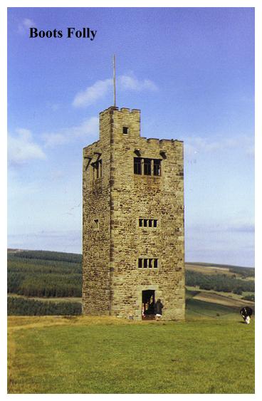
Boots's Folly is a curious and mysterious structure. It quite obviously contains masonry from an earlier farmhouse. The entrance has a 17th century datestone and the windows of the lower storeys contain old mullions obviously extracted from elsewhere. The upper windows are by contrast, relatively modern, with metal frames. The interior is now ruinous, but enough of it survives to reveal that it consisted of a wooden staircase leading around the walls up to a single chamber on the top storey, which is still floored. Beyond, another small staircase presumably gave access to the upper turret, where there is a flagpole.
The folly is basically a fanciful 'castle' built in the style of of a pele (or 'peel') tower, the traditional defensive homestead of the anglo/scottish border. Like most follies, various stories exist explaining why it was built. According to one account it was the work of a grieving widower, built so he could look across Bradfield Dale to the churchyard where his dear wife was buried. The truth is rather less romantic, for the fifty foot high tower was built in 1927 by Mr. Charles Boot, who lived nearby, simply to entertain his friends! The date is remarkable, this must be the most modern folly so far encountered in our travels.
Mr Boot used dressed stones and mullions cannibalised from demolished farms to build his belvedere. Inside, a wooden staircase wound round to a viewing platform. Local legend asserts that not too long ago a curious cow found its way into the tower, climbed the stairs and got hopelessly stuck! A rescue attempt then had to be launched to extricate the stricken animal. Perhaps it was to prevent a re-occurrence of this that the lower section of the internal staircase was removed. Consequently there is no longer any access to the viewing platform, which is sad.
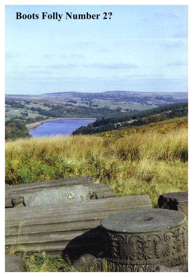
There are some unanswered questions hereabouts. The tower stands in a green pasture obviously reclaimed from the moors, as the two large piles of stones on the hillside testify. But when was the field cleared? Even more intriguing are the massive fragments of decorated classical columns and bits of ornately sculpted masonry lying adjacent to the path, slumbering in the heather on this windswept hillside. What are we to make of them? Obviously great expense and labour was employed to get the materials to this remote spot. It seems unlikely that they were brought here simply to be left. Could it be perhaps that our friend Mr. Boot had designs on constructing another folly, a project which fate prevented from coming to fruition? We have already seen that Mr. Boot was in the habit of cannibalising older buildings to get the materials for his follies. Perhaps under other circumstances we would have been visiting not only Boot's Folly but 'Boot's Temple' also. And a final question:- where were the columns cannibalised from? they are probably 18th century in origin, and were perhaps associated with some stately home, or aristocratic stable block perhaps. But where?? Somebody must know the answer!
After inspecting the folly retrace your steps, descending back to Tumbling Beck at Holes Clough Footbridge. Beyond the stream continue onwards through pastures with Dale Dike Reservoir on the left, to where a stile gives access to a plantation by a stone trough and the ruins of a farm.(There are seats here). One wonders if this ruin was the source of the masonry now incorporated into Boot's Folly. A well defined track leads through the woods before ascending right to meet tarmac at Blindside Lane.
Dale Dike reservoir is a lovely sheet of water. Its present tranquillity however gives no hint of its past notoriety, for in the last century it was the scene of a major disaster. The reservoir was the first to be constructed in this dale and was originally built in 1863-4, to slake the thirst and the steel of victorian Sheffield. The retaining dam was 1,200 feet long and a hundred feet high, holding back some 700 million cubic feet of water.
Unfortunately the project was something of a 'rush job', and it was allowed to fill up quickly, to satisfy the demand. Thus was the scene set for the terrible events of 11th March 1864, when a storm, lashing down the gorge, began to set up heavy waves on the lake, which beat fiercely upon the newly constructed embankment. Later that day it was noticed that a crack had appeared in the dam wall, and the engineer was called to the scene. When he arrived it was dark, and the crack had widened. The engineer decided to use gunpowder to blow a hole in the overflow spillway and take pressure off the dam, but it was already too late. Before they could do anything, the centre of the dam burst and a great wall of water thundered into the valley beyond!
Villagers in the upper part of the dale had already been alerted to the danger, and when they heard the roar of the flood they were able to scramble up to higher ground, out of danger. The only casualties were a man who had scoffed at the warning and gone to bed, and a baby washed from its mothers arms. Further down dale people were less lucky. The deluge caught whole communities completely by surprise. By now the torrent was carrying large quantities of wreckage, which smashed into buildings like battering rams. 240 people were killed, 4,511 houses flooded and 39 houses totally obliterated. The water company had eventually to pay out £276,918 in compensation for the death, injury and destruction caused. The new dam was rebuilt 400 yards upstream of the original one, being completed in 1875. The remains of the old dam wall are now hidden beneath the swaying conifers.
On reaching the road at Blindside Lane bear left, passing a cottage and a bungalow, as the road descends to a bridge over the beck by Doe House Riding School. Beyond, the Low Bradfield road is joined by an old sign which points to 'Wragg House Plantation'.From now on on we must take to the tarmac with all the hazards to life and limb that that entails. Turn left, and follow the road back up Bradfield Dale, passing the Haychatters Arms on the right.
Continue along the road, passing Walker House Farm on the right. By Thornseat House (left) the route has been diverted. Instead of turning onto this track, continue along the road, which winds uphill (beware of manic BMW drivers!) and passes behind Thompson House Farm before encountering a track on the left which descends to rejoin the track from Thomson Farm. Just beyond two small square cottages, bear right along a well defined route which leads around the front of the newly restored Hallfield.
This beautiful old 17th century mansion, four storeyed with fine old mullions, was derelict until recently, but has since been tastefully restored. Adjacent to it is fine old cruck barn. The house was once part of the Fitzwilliam estates. The path (well defined) runs around the front of it. From Hallfield a track leads past Stubbins to rejoin the outward route by the Strines Dam at Braggin. From here a simple stroll leads back to the carpark, and perhaps a pint at the Strines Inn.