BURNLEY TO BINGLEY MAPS


Safe Hill Walking
'Burnley to Bingley' crosses large area of South Pennine Uplands. While walking in the Pennine Hills is hardly 'mountain walking', the Moors should
nevertheless be treated with a degree of respect. Food & drink,stout boots, warm clothing and waterproof jackets should be the order of the day.
While there are no serious physical hazards (save for the odd busy road that needs to be crossed, and the occasional bog) there are other, more insidious dangers.
South Pennine weather is notoriously changeable. Mist and cloud can fall at the drop of a hat and if it starts raining hard it can sometimes go on for days!
In winter and early spring driving rain and freezing gale force winds can turn even the most exciting expedition into a cold, soggy, weatherbeaten misery. Also you will be hard pressed to complete the walk in the daylight hours at this time of year.
(no one has yet tried a night crossing!) If, by some remote chance you do get into difficulties and need to get off the route quickly, you should (between Burnley and High Brown Knoll) head South towards the urban Calder Valley. Beyond Nab Hill, towards Bingley
you should head north towards the Oxenhope/Haworth/Keighley conurbation. If you respect the hills and exercise simple common sense you should need to do neither.
Access to Route
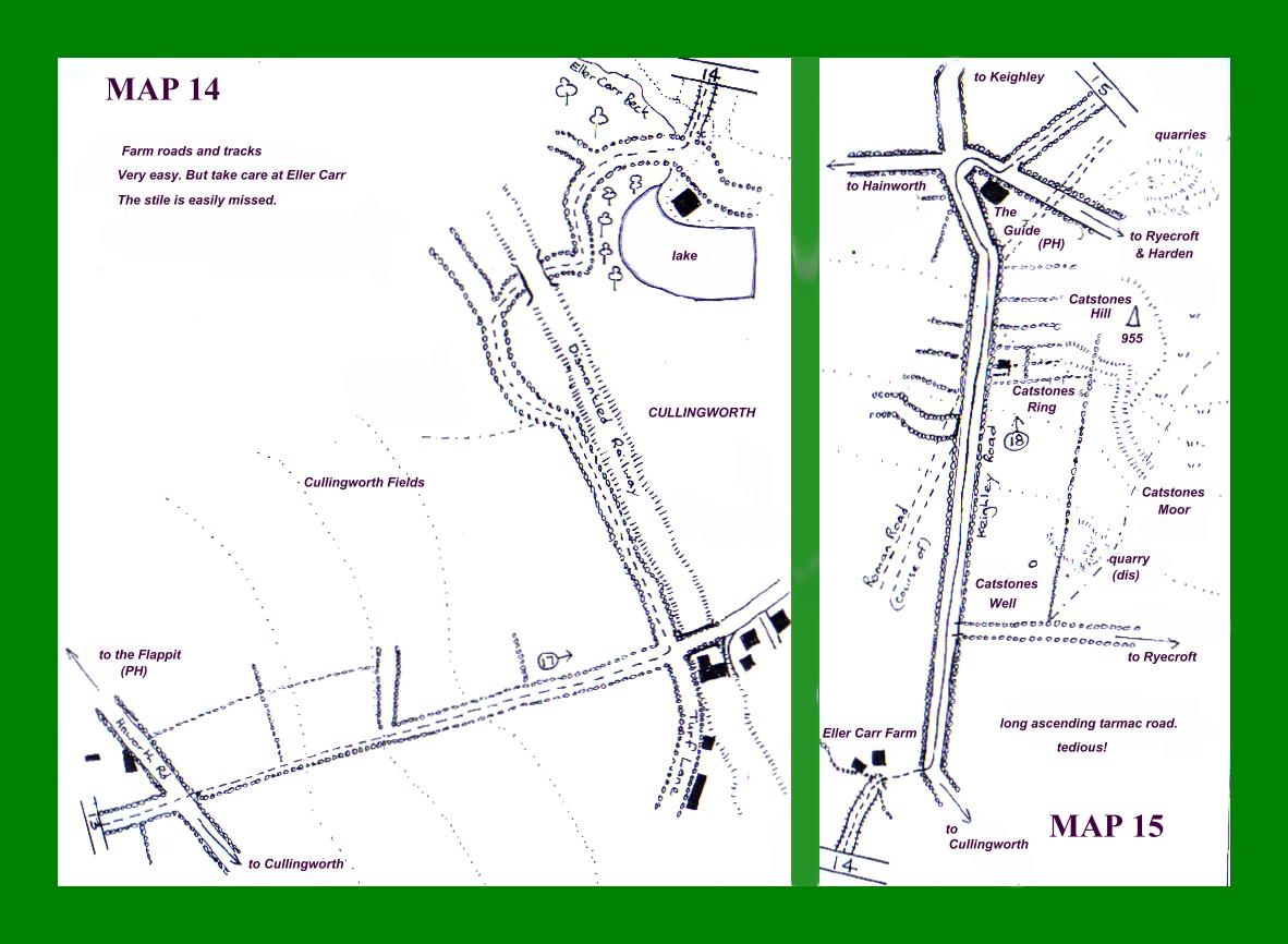
Burnley to Bingley is a linear walk, so it naturally follows that when you walk it you are going to finish up a long way from your starting point. At the end of a long days' slog
the burning question is going to be "how do I get home?"
Happily, due to the prescence of urban areas to the south and north west of the route there is a fair amount of interconnecting public transport available. There are railway stations at Bingley and also one at Manchester Road, Burnley, (although this one
is some distance from the start of the walk.) Bingley station connects to Bradford (Forster Square) Leeds, Keighley and Skipton, while Burnley links Leeds, Bradford (Interchange) to Preston & Blackpool via Hebden Bridge. Hebden Bridge, in turn, connects to Manchester via Todmorden & Rochdale.
On the buses you are better served. Buses run from Skipton & Keighley through Bingley to Bradford; and from Bradford there is a direct bus service to Burnley via Halifax, Hebden Bridge and Todmorden, which will drop you at Towneley Side adjacent to Towneley Hall.
As you should allow around nine hours for the walk, your public transport arrangements will need to be thought out. This is best acheived in the first instance by visiting http://www.westyorkshirebuses.freeserve.co.uk/timetables.htm Appropriate bus and train timetables are also available throughout the area.

Copyright JIM JARRATT 2002
Created by IrfanView

Copyright JIM JARRATT 2002
Created by IrfanView