Beyond High Brown Knoll the path is very indistinct:- you bear left and downhill until you arrive at a catchwater drain spanned by a stone bridge. This channel is actually spanned by a succession of small stone bridges, so if you miss the first one you will soon find another further along. Whichever bridge you arrive at, cross it and turn left, following the path along the far bank of the channel. The catchwater drain winds around the head of Luddenden Dean, skirting Bare and Spa Cloughs. Across the valley may be seen Warley Moor with its Rocking Stone, and beyond that the white Withens Hotel surrounded by little masts and aerials.
The Withens Hotel must be one of the loneliest pubs in the West Riding. In winter it stands aloof, high and remote, bleak and forbidding as it squats on its perch at the top of Cold Edge. At night it becomes a floating light in the darkness, visible for miles around.(Alas! it has since closed for business- spring 2002, and looks set to be made into a house!) After a long slog along the catchwater drain our route arrives at the Warley Moor Reservoir Dam. Here I began to worry about the dog. My short legged little Jack Russell terrier was hanging back, and I began to suspect that she was tiring. Looking back at one point I discovered to my horror that she had disappeared. I turned back along the path. A short distance away, behind a clump of heather, I observed four twitching legs pointing up towards the sky. Oh my God! I thought, she's keeled over and had a heart attack! I rushed over, only to find the mucky pup rolling ecstatically on the rotting entrails of a dead sheep!
On reaching the dam, do not bear right along it, instead turn left over the last bridge on the catchwater drain. Now turn right and follow the iron fence around the edge of the reservoir. Soon it becomes broken, and just beyond a peat channel bears to the right. Leave it, and struggle onwards over open moor to eventually join a gravel track which leads up to the road beneath Nab Hill. All around are ruined walls and abandoned quarries, all that remains of the once prosperous farming and delving community of Fly. (Note: Warley Moor Reservoir is depicted on older O.S. Maps as Fly Flatts Reservoir). From the Withens Hotel to the Keighley/Hebden Bridge Road by the Waggon and Horses there is hardly a single building except for the Sailing Club House on the reservoir and the new windfarm presently under construction (1993). But in the nineteenth century this was a relatively populous area sporting an assortment of farmsteads and a beershop, 'The Delvers Arms'. A drawing in Whiteley Turner's 'Springtime Saunter' (published at the turn of the 20th century) shows six farms beside Fly Flatts alone. Yet even in Turner's day the area was depopulating. He tells us how within the space of forty years 15 working quarries had shrunk to two. 300 men and fifty to sixty horses to a mere five men. As to the population in the area - 'just three couples remain'. The quarrying at Fly Flatts was not without its share of accidents. On 4th May 1860. John Holgate's horse, Jerry, tripped him in the delph gate and the loaded cart ran over him. A second fatality was John Dawson, who was struck by a flying stone in a blasting operation on October 13th 1864. John Whitaker was killed instantly in February 1869, when a 15 cwt stone, loosened by a thaw after strong frost fell upon him. Whiteley Turner also mentions drownings at nearby Slade and Cold Edge. All in all this bleak area seems to have had its share of tragedy over the years.
Yet there are ghosts at Nab Hill far older than these. At Nab Hill and nearby Hambleton Top have been found the pigmy flints of mesolithic hunter/gatherers who made their summer camps here during their nomadic wanderings over the Pennine hilltops. Their traces have been found as far afield as Derbyshire and the Cheviots, and they appear to have been based in the caves at Cresswell Crags in Derbyshire, a site of very ancient occupation. These mysterious people, dubbed 'Tardenoisian', were the very first people to walk the 'Pennine Way', and their tiny flints are usually found where the peat layer meets the bedrock. On these hills they set up workshops, and it is not too hard to imagine these small unknown people of long ago, sitting up here on a summers evening, flaking their highly valued flints, carried with them from other parts, and speculating on the days hunting and what game might be had further afield. The weather was milder in those far off times and the whole area was clothed in birch woodlands. I suspect they would not have liked Nab Hill as it is today, boggy, quarried and belaboured by wind and rain.
Today there is the windfarm. A source of continuing controversy in the area, it has ruffled the feathers of those waxed jacketed 'off comed 'uns' who when not commuting to Manchester and Leeds sit in their newly restored hillfarms and lament the desecration of 'our' landscape by white windmills. Yes, windfarms are unsightly and alien, but so are the coniferous plantations which are starting to appear on the hills, and so for that matter is Stoodley Pike Monument, but I hear no-one suggesting that that be pulled down. Yet how can anything be alien in a landscape that is essentially man made anyway? From the mesolithic hunters onwards man has shaped the landscape, felling the trees, replacing boulders with walls taking in the land for rough farming, building roads, quarries, reservoirs and tunnels, creating the Pennine landscape we see today. If the ruins at Fly Flatts tell us anything it is that mans continuing modification of the landscape is ultimately transitory, and in the end only the wasteland and wilderness remain. Those who find windfarms ugly today would have been horrified by the industry of the 1950's which characterised a vanished West Yorkshire which my memory still holds dear. Man has always moulded the landscape, and will continue to do so. Windfarms, TV masts and towers, 19th century follies lend character to a landscape that though wild and beautiful is essentially featureless and monotonous. These structures may come and go, but the wastelands will remain.
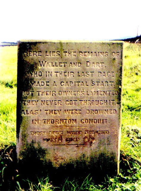
On reaching the lane below Nab Hill bear right, then left, following a quarry track up towards the edge of the escarpment. Where the track bears right into a quarry, leave it and continue straight onwards over quarry spoil, keeping to the edge of the escarpment. Soon a group of cairns come into view. To the right, some distance away, may be seen the ordnance survey pillar on Nab Hill (Do not attempt to reach it, as a maze of quarry delphs and peat channels lies between). Beyond the cairns a fairly distinct path leads along the edge of the hillside, skirting the tops of Great and Little Cloughs. Below may be seen the catchwater drain for Thornton Moor Reservoir, and, just beyond, White Moor Lane and Sawood Lane (the bad weather route). Two dogs were drowned in the catchwater drain, and the event is commemorated on their gravestone, which is to be found in a field opposite the Withens Hotel at Cold Edge:-
'Here lie the remains of Wallet and Dart Who in their last race made a capital start But their owners lamented, they never got through it, Alas they were drowned in Thornton Conduit...' These dogs were drowned on March 31st 1891'
From the edge of the moor there are fine views over Leeming Reservoir down to Oxenhope, and distantly the Three Peaks may be seen . Soon the path reaches disused quarry delphs at Hambleton Top. Continue onwards, aiming for two stone gate stoops framed in the foreground of Thornton Moor Reservoir.At the stoops Hambleton Lane is discovered coming down from the moor in a grassy gully. Turn left, and follow Hambleton Lane down to a water authority gate with a notice on it. Pass through the gate and bear right, passing through a succession of gates by the reservoir and waterworks buildings. Where the metalled track bears right, pass through a green iron gate on the left, from here a farm road passes Cobling and the riding school at Sawood to emerge on the Denholme-Oxenhope road opposite the Dog and Gun Inn. It's a good pint here, and there used to be a bull ring in the back room. You never know, it might still be there!