Follow the path over Black Moor, passing through a wall and continuing to a gate at the end of a walled lane (Crumack Lane). Do not pass through this gate, but instead bear right, following the wall. From Black Moor there are views down to Cullingworth, Catstones Moor and the Guide Inn. Beyond the Guide, power lines and a low line of trees mark the edge of the St. Ives Estate and the start of the Altar Road leading down to Bingley. Beyond lies Rombalds Moor on the far side of Airedale with its twin masts near Whetstone Gate, which leads over to Ilkley. All this lies beyond Bingley, which is out of sight in the valley below St. Ives. In the distance to the right can be seen the caravan site at Dobrudden Farm, high above Shipley Glen.
The wall along the edge of Black Moor soon reaches the end of Cuckoo Park Lane, just beyond some quarry workings. Do not turn up Cuckoo Park Lane, instead bear right over open moor down to the busy A629 Denholme-Keighley road at New Bridge. The going is rather tough over this short section of moorland where the bracken can be chest deep. At New Bridge a kissing gate gives access to the A629. Cross the road, and follow it left, towards the Flappit. A short distance along, before reaching the bend, turn right down a track behind Spring Head Farm.
Not far from here, (on the other side of the main road, over a wall) may be seen the earthworks of Castle Stead Ring. At present there remains about a quarter of a circle. The remainder of this ring was destroyed when the track was built to the allotment. It was probably one of a line of Brigantian forts, or else a fortified enclosure for livestock. A similar earthwork exists not too far away at Moat Hill near Denholme.
The route behind Spring Head Farm leads down to the Haworth-Cullingworth road, which, like the A629 leads to the Flappit. Cross this road, and continue onwards, following a path down the left hand side of a wall. The path passes through a succession of kissing gates and eventually becomes a track leading down to a disused railway bridge behind Cullingworth. Do not cross the bridge, instead turn left along a farm road running alongside the disused railway line passing Cullingworth Fields on the left. Where the track splits take the right hand fork, passing under a railway bridge. This track leads into Eller Carr Woods, bearing right around a small lake (Ignore the track coming in from the left).
Eller Carr Woods, with its crags and lake, was a popular picnic spot in victorian times. One writer of the day described it thus:- 'Eller Carr the beautifulEller Carr the Grand,
One of the fairest spots art thou
In this our native land........... '
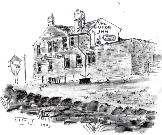
Just before the track winds round to the house that hangs spectacularly on a crag overlooking the lake, look for a stile on the left (easy to miss). Beyond the stile the path ascends through a field between wire fences to a second stile; from where it crosses a very short pasture to emerge on Keighley Road just below Catstones Moor. Turn left and follow the road up to the Guide Inn. The road runs straight and it is not surprising to find it depicted on some maps as a 'long causeway' or 'roman road course of'. Where the road turns left towards the Guide the course of the roman road continued onwards, no doubt leading eventually to the roman fort at Olicana (Ilkley). Although I am by no means an expert on roman roads it seems a reasonable assumption that this was part of the Eboracum - Deva road (York to Chester). If this is so, then it is part of the same road that passes over Cold Edge in Calderdale on its way to Blackstone Edge and Littleborough.
At the Guide Inn the walker is greeted by the jaunty figure of a rambler painted on the pub wall following a signpost 'to Bingley'. Now at last one begins to feel that one is getting somewhere! When I arrived, with my by now limping terrier, the sun was hanging low in the west while couples sat outside drinking and enjoying the view. Tired and anxious to beat the darkness I pressed on.
Previous Page
Next Page